In the Spotlight
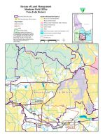
Road Access into Blair Fire Area (north of King Hill, Idaho) Open to Accomodate Seasonal Recreation Use June 1 - December 31, 2012: As hunting season approaches, the Bureau of Land Management (BLM) would like to remind public land users that road access into the Blair Fire burn area, north of King Hill, Idaho, is open from June 1, 2012 until December 31, 2012 in order to accomodate seasonal recreational use. The areas available include: BLM Road, Walker Reservoir Road and Lower Hog Creek Road. This area will re-open again June 1 - September 5, 2013. The motorized vehicle closure still remains in effect for the rest of the burn area, including all other routes. Non-motorized travel is allowed throughout the area. MAP | More Information
The BLM is developing a TMP for all the lands it manages north of Hwy-20, between Chimney Creek on the west and Craters of the Moon/Fish Creek on the east. |  |