Perry-Castañeda Library
Map Collection
Iraq Maps
Iraq Maps:
Iraq Maps on Other Web Sites:
The following maps were produced by the U.S. Central Intelligence Agency, unless otherwise indicated.
Country Maps
City Maps
- Al Basrah (Special Reference Graphic) NIMA 2003 (2MB)
- [Al Basrah] Basra (topographic map in Russian) original scale 1:200,000 Portion of Soviet General Staff map H-38-XVIII 1990 (540K)
- Al Mawsil (Mosul) (Special Reference Graphic) NIMA 2003 (1.8MB)
- Baghdad From Central and Southern Iraq [map], CIA, February 2003 (250K)
- Baghdad (Special Reference Graphic) NIMA 2003 (1.5M)
- Baghdad National Geospatial-Intelligence Agency 2006 (3.3 MB)
- Baghdad CIA 1992 (206K)
- Baghdad U.S. Dept. of State 1981 (98K)
- Central Baghdad 1998 (428K) Kenny Hopper, University of Texas
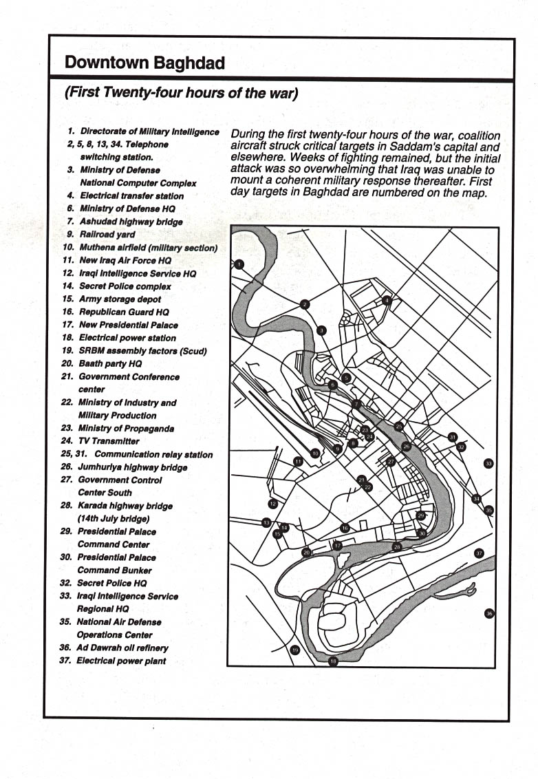
- Downtown Baghdad: Initial Targets Jan. 1991 From Decisive Force by Richard G. Davis, U.S. Air Force, 1996 (201K)
- Baghdad - North (topographic map in Russian) original scale 1:200,000 Portion of Soviet General Staff map I-38-XXI 1991 (843K)
- Baghdad - South (topographic map in Russian) original scale 1:200,000 Portion of Soviet General Staff map I-38-XXVII 1991 (833K)
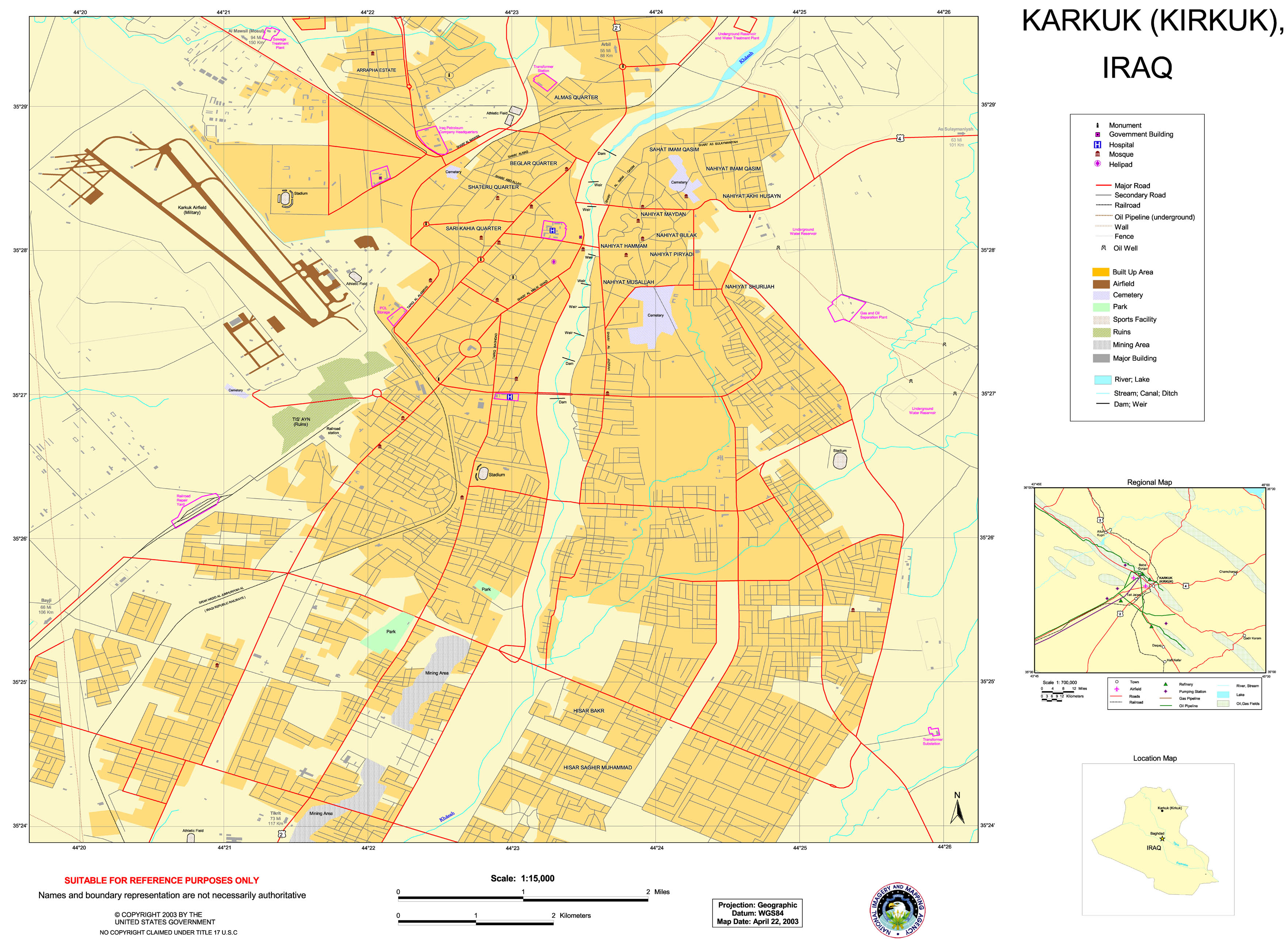
- Karkuk (Kirkuk) (Special Reference Graphic) NIMA 2003 (1.3MB)
- Tikrit (Special Reference Graphic) NIMA 2003 (1.4MB)
- Tikrit (topographic map in Russian) original scale 1:200,000 Portion of Soviet General Staff map I-38-XIV 1972 (263K)
Detailed Maps
- Iraq - Joint Operations Graphic Series 1:250,000, NIMA, Clickable Index Map. Not for navigational use
- Iraq - Operational Navigation Chart Series 1:1,000,000, DMA/NIMA, Clickable Index Map. Not for navigational use
- Al Basrah Region - Oil and Gas Fields original scale 1:670,000 From Iraq-Iran: Central and Southern Border Areas CIA 1980 (400K)
- Al Mawsil [Mosul]-Arbil [Irbil] Region, Northern Iraq (tactical pilotage chart) original scale 1:500,000 Portion of Defense Mapping Agency TPC G-4B 1989 (927K) Not for navigational use
- Baghdad Region original scale 1:670,000 From Iraq-Iran: Central and Southern Border Areas CIA 1980 (1136K)
- East-Central Iraq From Iraq a Map Folio CIA 1992 (181K)
- Iraq/Jordan Border (operational navigation chart) original scale 1:1,000,000 Portion of Defense Mapping Agency ONC G-4 1990 (833K) Not for navigational use
- Turkey (wall map) 2002 Includes Northern and Central Iraq, Shows Air Bases. Inset map of Tigris and Euphrates Drainage Basin
Thematic Maps
- Iraq: Administrative Divisions From Atlas of the Middle East, CIA, 1993 (69K)
- Iraq: Area Comparison From Atlas of the Middle East, CIA, 1993 (38K)
- Iraq: Country Information From Atlas of the Middle East, CIA, 1993 (128K) Flag and statistics, not a map
- Iraq: Dissident Areas From Iraq a Map Folio, CIA, 1992 (170K)
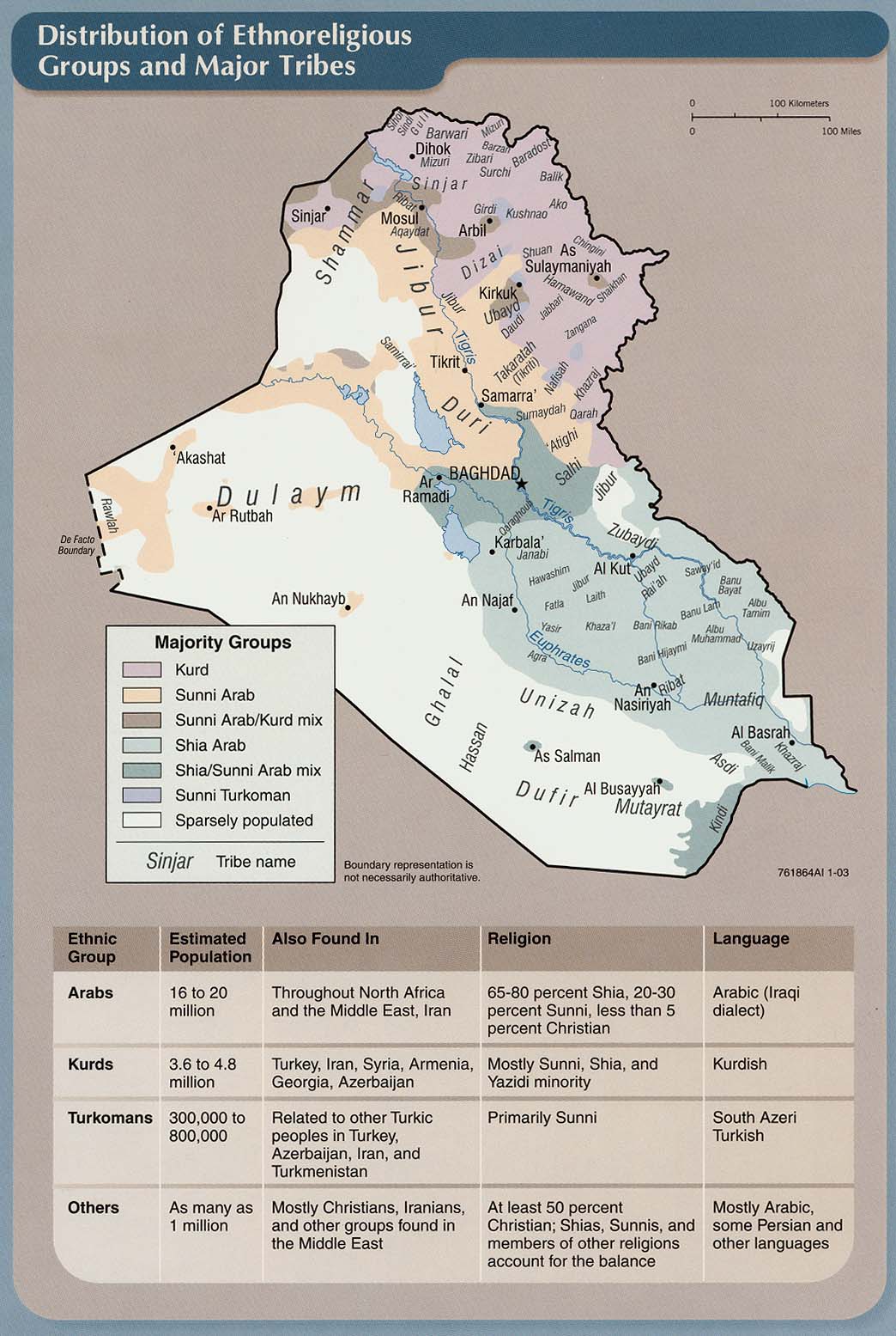
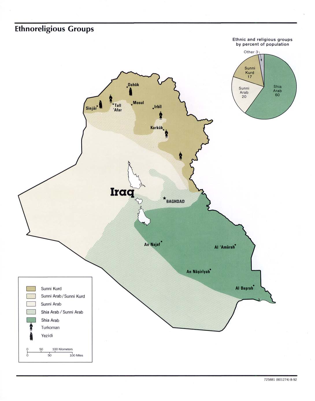
- Iraq: Distribution of Ethnoreligious Groups and Major Tribes From Iraq: Country Profile [map], CIA, January 2003 (215K) and
pdf format (216K)
- Iraq: Distribution of Religious Groups and Ethnic Groups from Map No. 503930 1978 (163K)
- Iraq: Economic Activity From Atlas of the Middle East, CIA, 1993 (115K)
- Iraq: Economic Activity from Map No. 503930 1978 (134K)
- Iraq: Ethnoreligious Groups From Iraq a Map Folio, CIA, 1992 (112K)
- Iraq: Land Use From Iraq: Country Profile [map], CIA, January 2003 (213K) and
pdf format (211K)
- Iraq: Land Use From Atlas of the Middle East, CIA, 1993 (111K)
- Iraq: Land Utilization from Map No. 503930 1978 (127K)
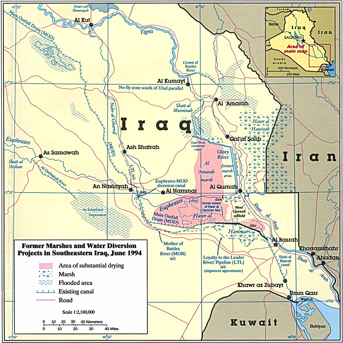
- Iraq - Marshes - Former Marshes and Water Diversion Projects in Southeastern Iraq From The Destruction of Iraq's Southern Marshes, CIA Publication IA 94-10020, 1994 (243K)
- Iraq: Oil Infrastructure From Iraq: Country Profile [map], CIA, January 2003 (157K) and
pdf format (160K)
- Iraq: Oilfields and Facilities From Iraq a Map Folio, CIA, 1992 (182K)
- Iraq: Physical Features From Iraq: Country Profile [map], CIA, January 2003 (226K) and
pdf format (221K)
- Iraq: Population from Map No. 503930 1978 (124K)
- Iraq: Population Density From Iraq: Country Profile [map], CIA, January 2003 (213K) and
pdf format (183K)
- Iraq: Population Density From Atlas of the Middle East, CIA, 1993 (185K)
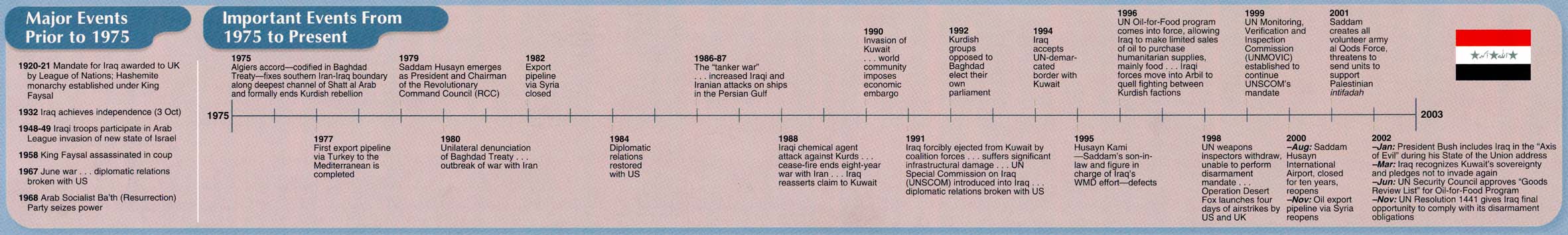
- Iraq: Time Line "Major Events Prior to 1975, Important Events from 1975 to Present" From Iraq: Country Profile [map], CIA, January 2003 (151K) Chart
- Iraq: Time Line From Atlas of the Middle East, CIA, 1993 (210K) Chart
- Kurdish Areas in the Middle East and the Soviet Union 1986 (254K)
- Kurdish Areas of Northern Iraq From Iraq: Country Profile [map], CIA, January 2003 (165K) and
pdf format (164K)
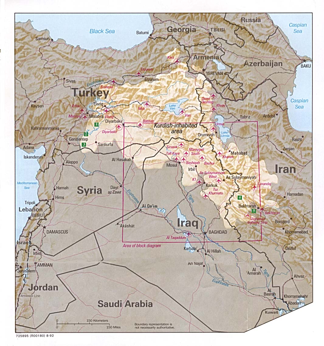
- Kurdish Lands From Iraq: A Map Folio, CIA, 1992 (319K)
- Kurdish Lands (location map) From Iraq: A Map Folio, CIA, 1992 (235K)
Historical Maps
- Babylon From Iraq and the Persian Gulf. Great Britain. Naval Intelligence Division, 1944 (173K)
- Babylon 1829 (229K)
From Travels in Chaldaea, including a journey from Bussorah to Bagdad, Hillah, and Babylon,
performed on foot in 1827, published by Henry Colburn and Richard Bentley, London, 1829.
- Baghdad 1849 (176K)
Part of "The River Euphrates From Hit to the Kuthah River and The River Tigris from Sammara to the Abu Hitti Canal..."
from Maps volume, sheet VII of The Expedition for the Survey of the Rivers Euphrates and Tigris, Carried on by Order of the British Government in the years 1835, 1836, and 1837...
by Francis Rawdon Chesney. London, Longman, Brown, Green, and Longmans, 1850.
- Baghdad 1944 From Iraq and the Persian Gulf. Great Britain. Naval Intelligence Division, 1944 (346K)
- Baghdad - Northwest Baghdad No. 1, 1:12,500, Edition 3-AMS, Series K941. U.S. Army Map Service, 1958 (7.3MB)
- Baghdad - Northeast Baghdad No. 2, 1:12,500, Edition 3-AMS, Series K941. U.S. Army Map Service, 1958 (4.4MB)
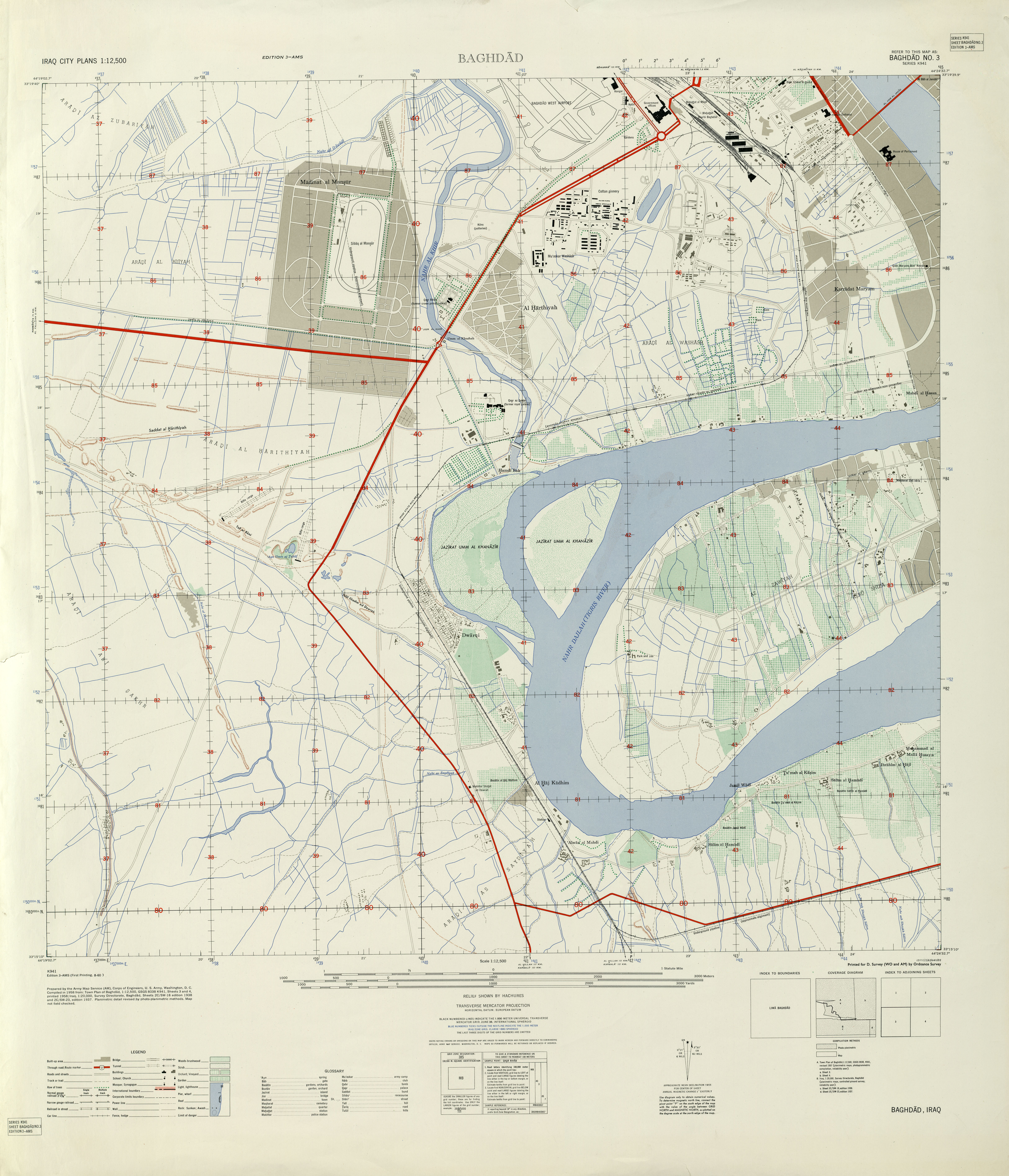
- Baghdad - Southwest Baghdad No. 3, 1:12,500, Edition 3-AMS, Series K941. U.S. Army Map Service, 1958 (4.8MB)
- Baghdad - Southeast Baghdad No. 4, 1:12,500, Edition 3-AMS, Series K941. U.S. Army Map Service, 1958 (5.7MB)
- Baghdad 1961 Baghdad Bus Map (708K) and map cover and route information (291K)
- Basra Area 1942 (423K) map key and scale (185K)
Part of sheet H-38 L Basra. Edition June 1942. Original scale 1:253,440 Compiled and Reproduced by India Field Survey Company, December 1942. Published by the U.S. Army Map Service, May 1943.
- Erbil 1944 From Iraq and the Persian Gulf. Great Britain. Naval Intelligence Division, 1944 (238K)
- Iraq: Ballistic-Missile-Related Facilities From Iraq's Weapons of Mass Destruction Programs, U.S. Director of Central Intelligence, October 2002 (37K)
- Iraq: CW-Related Production and Declared Sites of Deployed Alcohol-Filled or Chemical Agent-Filled Munitions During Desert Storm From Iraq's Weapons of Mass Destruction Programs, U.S. Director of Central Intelligence, October 2002 (62K)
- Iraq: Declared BW-Related Sites From Iraq's Weapons of Mass Destruction Programs, U.S. Director of Central Intelligence, October 2002 (52K)
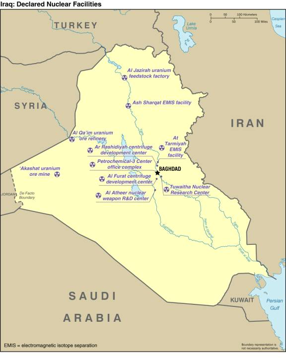
- Iraq: Declared Nuclear Facilities From Iraq's Weapons of Mass Destruction Programs, U.S. Director of Central Intelligence, October 2002 (39K)
- Iraq Oil Industry Operations 1953 From Iraq Today. Directorate-General of Propaganda, Baghdad, 1953
- Iraqi Missile Capabilities From Conduct of the Persian Gulf War: Final Report to Congress, U.S. Dept. of Defense, April 1992 (338K)
- Iraq Tourist Map - North,
Iraq Tourist Map - South and map legend from Iraq Tourist Map. Iraq Tourism Administration, ca. 1970 (935K)
- Iraq - Southern Deserts of Iraq From Iraq and the Persian Gulf. Great Britain. Naval Intelligence Division, 1944 (177K)
- Iraq - Western Desert of Iraq From Iraq and the Persian Gulf. Great Britain. Naval Intelligence Division, 1944 (211K)
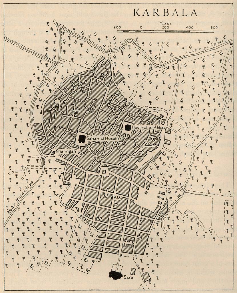
- Karbala 1918 "Sketch-plan of Karbala in 1918" from Iraq and the Persian Gulf. Great Britain. Naval Intelligence Division, 1944 (243K)
- Kuwait Historical Maps 1987-1991
- Mosul 1944 From Iraq and the Persian Gulf. Great Britain. Naval Intelligence Division, 1944 (317K)
- Tigris and Euphrates Near Baghdad, Ancient and Modern Courses From Iraq and the Persian Gulf. Great Britain. Naval Intelligence Division, 1944 (209K)
- Other Middle East Historical Maps
Iraq Maps on Other Web Sites
Country and Thematic Maps on Other Web Sites:
Iraq City Maps and Satellite Images on Other Web Sites:
Notes: Additional city/topographic maps are available on:
United Nations Assistance Mission for Iraq, including maps for Amarah, Baghdad, Basrah, Dahuk, Diwaniya, Erbil, Fallujah, Hilla, Kerbala, Kirkuk, Kufa, Kut, Mosul, Najaf, Nassriyah, Ramadi, Samawah, Sulaymaniyah, Tikrit and Umn Qasr.
Detailed satellite and airphoto imagery for Iraq is available in Google Earth. This requires free software installation. The imagery for Baghdad is very detailed.
Google Maps,
Live Search Maps and
Yahoo Maps
also have satellite imagery for Iraq.
- Az Zubayr (GlobalSecurity.org)
- Baghdad (hot-maps.de)
- Baghdad [2003] (National Geographic)
- Baghdad (NBC5/WMAQ Chicago) [requires Flash]
- Baghdad - Green Zone Map [2007] (BBC News)
- Baghdad - Green Zone Maps (GlobalSecurity.org)
- Baghdad - Mapping the Violence [2003-2007] (BBC News) [Flash]
- Baghdad - Portion of Central Baghdad (Karto Atalier/Omni Resources)
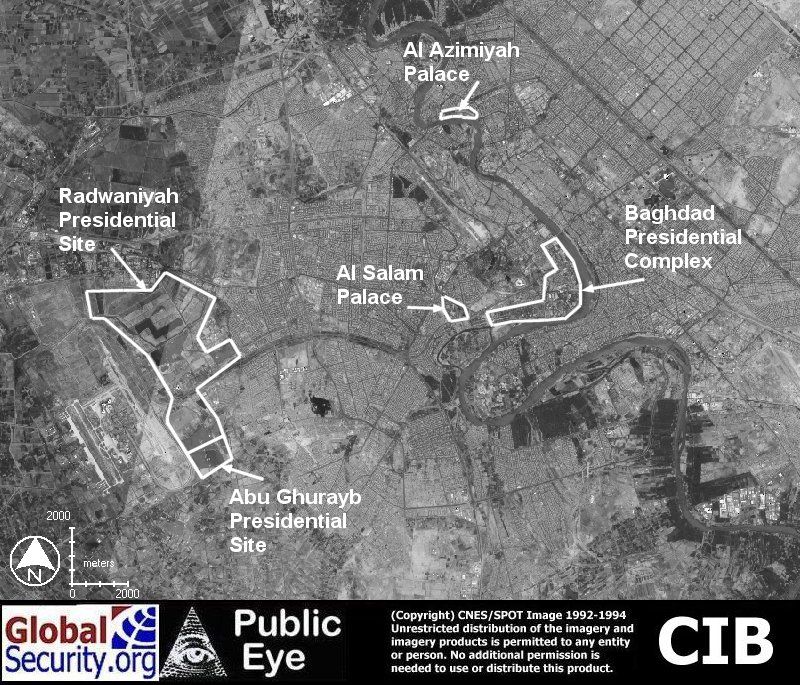
- Baghdad - Presidential Sites (GlobalSecurity.org)
- Baghdad - Satellite Images [1998] (Washington Post)
- Baghdad - Scrollable Map (Guardian Unlimited) [requires Flash]
- Baghdad - Sectarian Divisions Map [2006] (HealingIraq.Blogspot.com)
- Baghdad and D.C. Regions Compared (Washington Post)
- Diwaniyah (GlobalSecurity.org)
- Fallujah - Maps and Satellite Imagery (GlobalSecurity.org)
- Karbala - Maps (GlobalSecurity.org)
- Mosul - Maps (GlobalSecurity.org)
- Mosul - Mosul Airport/Camp Marez Maps (GlobalSecurity.org)
- Najaf - Battle for Najaf (CNN/Internet Archive)
- Najaf - Maps (GlobalSecurity.org)
- Najaf - Satellite Image (Space Imaging Eurasia/GlobalSecurity.org)
- Ramadi (GlobalSecurity.org)
- Ramadi - Satellite Image (Cryptome)
- Sadr City, Baghdad - Map and Images (GlobalSecurity.org)
- Samarra, al-Askari Shrine [2004] (Space Imaging/GlobalSecurity.org)
- Iraq - Cities (GlobalSecurity.org)
Iraq Historical Maps on Other Web Sites [Gulf War 1990-1991]:
Iraq Historical Maps on Other Web Sites [1998]:
Iraq Historical Maps on Other Web Sites [2003]:
The War Day-by-Day 2003:
Iraq News Maps on Other Web Sites [2004-2009]:
More: Middle East Historical Maps on Other Web Sites


![[Al Basrah] Basra](middle_east_and_asia/basra_1990.jpg)
![Al Mawsil [Mosul]-Arbil [Irbil] Region, Northern Iraq (tactical pilotage chart)](middle_east_and_asia/iraq_north_g4b_89.jpg)
![Baghdad - Green Zone Map [2007] (BBC News)](https://webarchive.library.unt.edu/web/20121007165344/http://newsimg.bbc.co.uk/media/images/40070000/gif/_40070358_baghdad_haifa_st_map203.gif)
![Baghdad - Sectarian Divisions Map [2006] (HealingIraq.Blogspot.com)](https://webarchive.library.unt.edu/web/20121007165344/http://photos1.blogger.com/photoInclude/blogger/7155/257/1600/baghdad-updates-nov27.7.jpg)
![Samarra, al-Askari Shrine [2004] (Space Imaging/GlobalSecurity.org)](https://webarchive.library.unt.edu/web/20121007165344/http://www.globalsecurity.org/military/world/iraq/images/ik_SIME_samarra_29oct01_04.jpg)
![Iraq - Barley Production [1991] (USDA)](https://webarchive.library.unt.edu/web/20121007165344/http://www.fas.usda.gov/pecad/remote/mideast_pecad/iraq/regions/barley_iraq.jpg)
![Iraq - Wheat Production [1991] (USDA)](https://webarchive.library.unt.edu/web/20121007165344/http://www.fas.usda.gov/pecad/remote/mideast_pecad/iraq/regions/wheat_iraq.jpg)
![Operation Desert Storm: Ground Campaign [1991] (Rice University)](https://webarchive.library.unt.edu/web/20121007165344/http://es.rice.edu/projects/Poli378/Gulf/CPGW_Images/cpgw_294.gif)
![Occupation Zones [Iraq] (BBC News)](https://webarchive.library.unt.edu/web/20121007165344/http://newsimg.bbc.co.uk/media/images/39560000/gif/_39560495_iraq_troops6_416map.gif)