![[Text Graphic] US Forest Service](https://webarchive.library.unt.edu/web/20121007093917im_/http://www.fs.fed.us/gpnf/volcanocams/global/images/2007-header-usda-fs-text.gif "Return to USDA Forest Service home page in Washington, DC.")
- VolcanoCams Home
- Contact Us
- Frequently Asked Questions (FAQs)
- Images Archives
- Support Your VolcanoCams
- VolcanoCams News Blog
-
- News Blog Home
- September 2012
- August 2012
- July 2012
- June 2012
- May 2012
- April 2012
- March 2012
- February 2012
- January 2012
- December 2011
- November 2011
- October 2011
- September 2011
- August 2011
- July 2011
- June 2011
- May 2011
- April 2011
- March 2011
- February 2011
- January 2011
- December 2010
- November 2010
- October 2010
- September 2010
- August 2010
- July 2010
- June 2010
- May 2010
- April 2010
- March 2010
- February 2010
- January 2010
- December 2009
- November 2009
- October 2009
- September 2009
- August 2009
- July 2009
- June 2009
- May 2009
- April 2009
- March 2009
- February 2009
- January 2009
- December 2008
- November 2008
- October 2008
- September 2008
- August 2008
- July 2008
- June 2008
- May 2008
- April 2008
- March 2008
- February 2008
- January 2008
- December 2007
- November 2007
- October 2007
- September 2007
- August 2007
- July 2007
- VolcanoCams Site Map
Mount St. Helens VolcanoCams
VolcanoCam FAQs
Location Details
Where Is Mount St. Helens On A Map?
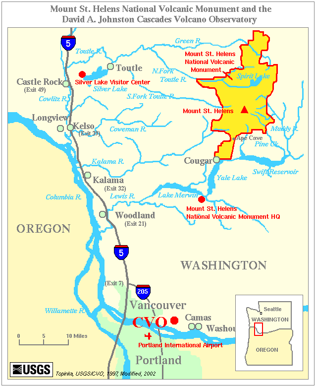
Below are two maps (modified from the original USGS maps). The maps show the approximate geographic location of Mount St. Helens within the Pacific Northwest (map one), and a close up map (map two) of the approximate locations of the Coldwater Ridge Visitor Center and the Johnston Ridge Observatory. The second map also show where the Mount St. Helens VolcanoCam is located and its approximate field of view.
Fast Faqs
- Mount St. Helens Summit Coordinates: 46.20 N, 122.18 W
- Summit Height: 2,549 Meters (8,364 feet (9,677 feet before May 18, 1980)).
Map One
Map Two

![[ Graphic Image ] USDA Logo / Forest Service Shield Dual Logo](https://webarchive.library.unt.edu/web/20121007093917im_/http://www.fs.fed.us/gpnf/volcanocams/global/images/2007-usda-fs-shield.gif)
Site design and support by USDA Forest Service
Northwest Enterprise Web Team (NEWT)
Mount St. Helens National Volcanic Monument
Pacific Northwest Region
USDA Forest Service
Page Last Modified: 20 July 2007 @ 4:38:54 PM EDT.
Page Location: http://www.fs.fed.us/gpnf/volcanocams/msh/library/faqs-location.php