U.S. National Weather Service125,307 likes · 8,214 talking about this
125,307 likes · 8,214 talking about this

- AboutNOAA National Weather Service is the U.S. Federal agency responsible for weather, water & climate forecasts & warnings.
For the official source of information about the National Weather Service, please visit our homepage at http://www.weather.gov/.

- Also On
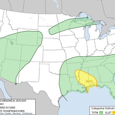
- ...Welcome Rainfall in the Southern Plains this Week...
Beneficial rainfall is forecast across much of the drought-stricken Southern Plains over the next couple days. This is partly in response to a cold front pushing through the northern ...and central U.S. which is ushering in the coldest temperatures of the new autumn season. Several inches of rainfall will be possible through Saturday across parts of Texas and Oklahoma.See More
http://www.hpc.ncep.noaa.gov/discussions/hpcdiscussions.php?disc=pmdspd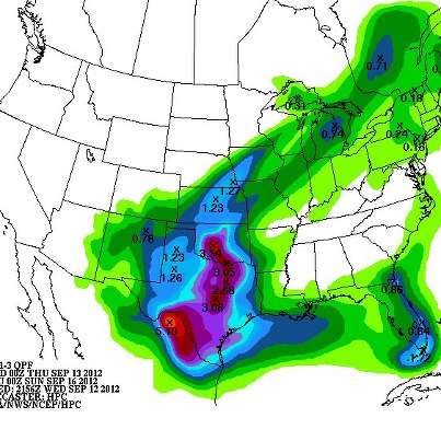
- LikesSee All
- US National Weather Service Greenville-Spartanburg SCGovernment Organization
- US National Weather Service Huntsville AlabamaGovernment Organization
- US National Weather Service Morristown TennesseeGovernment Organization
- US National Weather Service Jacksonville FloridaGovernment Organization
- US National Weather Service Arkansas-Red Basin River Forecast CenterGovernment Organization
- Tropical Depression Eleven Forms in the Eastern Pacific
Tropical Depression Eleven has formed in the Eastern Pacific Ocean. The system is located about 195 miles southwest of Manzanillo, Mexico. TD Eleven currently has maximum sustained wi...nds of 35 mph. Strengthening is forecast and the system could become a tropical storm tonight or on Thursday. The system is moving to the west-northwest at 10 mph and should maintain this track for the next several days, posing no immediate threat to land. Details...See More
http://www.nhc.noaa.gov/#ELEVEN-E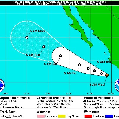
- Twenty years after Hurricane Iniki struck the Hawaiian island of Kaua’i as a Category 4 storm, with winds in excess of 140 mph, NWS forecasters in Hawaii have a much better arsenal of tools at their disposal for accurately predicting threatening weather, including tropical storms and hurricanes. Honolulu’s KHON2 News explains...
http://bit.ly/PbTxfN - Tropical Storm Nadine Forms in the Atlantic
Tropical Storm Nadine formed overnight in the Central Atlantic. Nadine is centered about 995 miles east-northeast of the Lesser Antilles. Maximum sustained winds are currently near 45 mph. Addit...ional strengthening is forecast and Nadine could become a hurricane by Thursday or Thursday night. Nadine is currently moving to the west-northwest at 17 mph, with a turn to the northwest forecast, along with a reduction in forward speed. This system currently poses no threat to land. Details...See More
http://www.nhc.noaa.gov/#NADINE
- Monsoon Activity Continues Flash Flood Threat for Southwest, Cooler in Central U.S.
Heavy rain and strong winds are possible with several disturbances moving across the Southwest on Wednesday. Flash Flood Watches are in effect for portions...of Colorado and Utah. Meanwhile, heavy snow is expected for the high peaks of Colorado, while temperatures will cool on Wednesday and Thursday across the Upper Midwest and central Plains with the passage of a cold front. Details...See More
http://go.usa.gov/RRX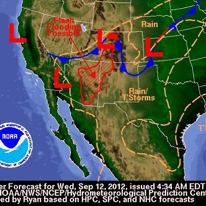
- ...Fire Weather Conditions Slowly Improving, but Threat Continues...
Very dry air will remain in place across much of the Great Plains, but winds will finally begin to ease on Wednesday. Conditions will remain favorable for the spread of w...ildfires on Wednesday across the northern Rockies and into portions of the northern and central Plains but will improve by Thursday.See More
http://forecast.weather.gov/wwamap/wwatxtget.php?cwa=usa&wwa=Red+Flag+Warning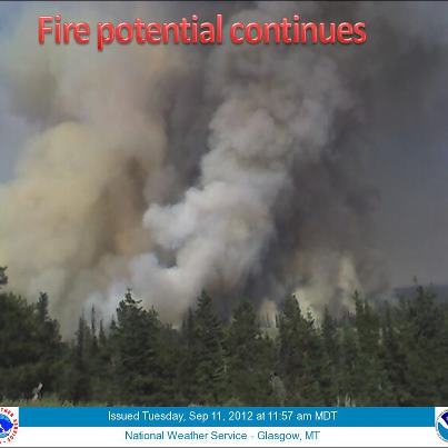
- Tropical Depression 14 Forms in the Central Atlantic
Tropical Depression 14 has formed in the Central Atlantic. This system is centered about 1,210 miles east of the Lesser Antilles. Maximum sustained winds are currently near 35 mph. Some ...strengthening is forecast and a tropical storm could form later today or tomorrow. TD 14 is currently moving to the west at 10 mph, a turn to the west-northwest is forecast soon, followed by a turn to the northwest. This system currently poses no threat to land.See More
http://www.nhc.noaa.gov/#FOURTEEN
- Critical Fire Weather Conditions Persist in Northern Rockies, Northern/Central Plains
Very warm temperatures combined with low relative humidity levels and gusty winds associated with the passage of a cold front will continue favorable con...ditions for wildfire development on Tuesday through at least Wednesday across the northern Rockies and into portions of the northern and central Plains. Conditions are forecast to improve later this week. Details...See More
http://www.spc.noaa.gov/products/fire_wx/fwdy1.html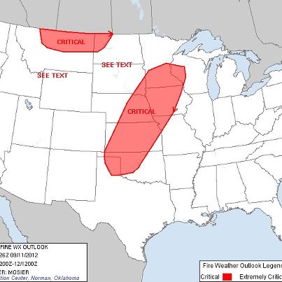
- ...Critical Fire Weather Conditions Spreading Through the Great Plains on Tuesday...
Strong winds, low humidity and drought will again lead to critical fire weather conditions on Tuesday for the northern Rockies and Great Plains. This may ...lead to rapid spread and growth of existing and new fires, creating a potentially dangerous situation. Red Flag Warnings have been posted for these areas.See More
Details...
http://forecast.weather.gov/wwamap/wwatxtget.php?cwa=usa&wwa=Red+Flag+Warning
- Last month, the internationally-recognized rock band Linkin Park became the first band in the nation to receive NWS StormReady® Supporter recognition. The rock band established severe weather safety plans which are an essential part of buil...ding a Weather- Ready Nation. They are a Force of Nature by taking the initiative to keep their workers and fans safe.See More
Read more…
http://nyti.ms/QCAHfx
http://www.nws.noaa.gov/com/weatherreadynation/news/091012_linkin.html
Pictured here are: Warning Coordination Meteorologist Rick Smith from the NWS Norman, Okla., forecast office (Standing-4th from left) along with WDT staffers and Linkin Park band members (Standing-far left) Joe Hahn, (Kneeling-L to R) Dave Farrell, Rob Bourdon, Chester Bennington, Brad Delson and (Standing-far right) Mike Shinoda (Photo: NWS Norman)
- When and where rain falls makes a big difference on how it affects drought-stricken areas. Take a look at a video that explains why Hurricane Isaac didn't give much relief to the U.S. drought.
http://www.climatewatch.noaa.gov/video/2012/downpours-and-droughts-timing-is-everything
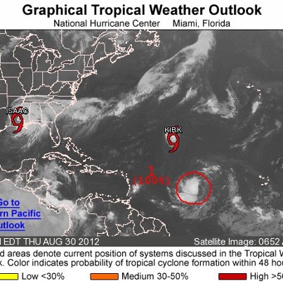
- High Chance of Tropical Cyclone Development in the Eastern Atlantic
Satellite imagery indicates the high chance of a tropical depression forming in the eastern Atlantic. The system, located about 855 miles west of the Cape Verde Island, ha...s a high chance — 90 percent — of becoming a tropical cyclone during the next 48 hours. The system is moving west-northwest at 15 to 20 mph. There are no current Watches, Warnings, or Hazards to land with this system. Details...See More
http://www.nhc.noaa.gov/gtwo_atl.shtml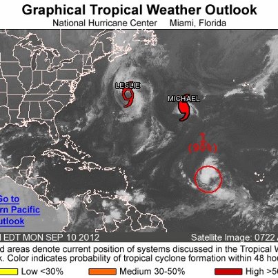
- ...Disturbance in Eastern Atlantic has Medium Chance for Tropical Cyclone Development in Next 48 Hours...
Shower and thunderstorm activity has increased near the center of a low pressure system located about 550 miles west of the Cape Verd...e Islands. Although upper-level winds are generally favorable, dry air in the vicinity of this disturbance could hinder development during the next day or so. This system has a medium chance (50 percent) of becoming a tropical cyclone during the next 48 hours as it moves west-northwestward at 10 to 15 mph.See More
Information and graphic courtesy of the NWS National Hurricane Center.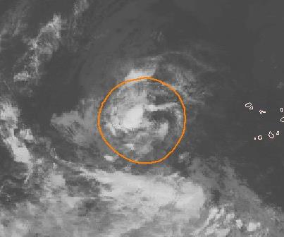
- ...Atlantic Storms Bring Rough Surf to the U.S. East Coast...
As Tropical Storm Leslie Spins in the Atlantic Ocean near Bermuda, swells from the storm are impacting the east coast of the U.S. Rough seas are expected for the next few days.... Small Craft Advisories are in effect all the way from Central Florida to Maine. The rough seas also bring a danger of rip currents as well. With the rough waters, take extra care on the beaches this week. Details...See More
http://www.ripcurrents.noaa.gov/
- ...Fire Weather Danger Continues to Plague the West...
Today's significant weather impacts turn from severe storms to fire weather. Hot, dry conditions have been persistent across the Northern Rockies, leading to an above-average fire sea...son. That trend continues today with the added threat for dry thunderstorms and more lightning-sparked wildfires. Areas of critical fire weather danger today include the western Dakotas, Eastern Idaho, and Southwestern Montana.See More
- ...Severe Thunderstorms Continue to Impact the Eastern U.S...
As of 4pm EDT, the NWS Storm Prediction Center has outlined the greatest threat for severe storms this evening across portions of southern New England and the northern Mid-Atlan...tic, or from eastern New York to central New Hampshire southward into northeast Maryland and northern Delaware, including New York City, NY and Philadelphia, PA.See More
The greatest threat will be widespread damaging winds (capable of downed trees and power outages) in association with a line of severe thunderstorms along an eastward moving cold front. Additionally, some storms will be capable of isolated tornadoes.
- ...Severe Weather Moving Through the Northeast Today...
A tornado has already been confirmed in the New York City Area and Tornado and Severe Thunderstorm Watches extend from Virginia to the Canadian border. A strong cold front is bringin...g dangerous weather including the threat for tornadoes to the region. This threat will continue through the afternoon as the system progresses eastward. Be sure to monitor local officials or media for warnings for your area if you are in the path of these storms. Details...See More
http://www.spc.noaa.gov/
- ...A Touch of Fall Coming to the Northern Plains...
Behind the cold front bringing severe weather chances to the east today, far cooler weather is moving in. Frost Advisories are in effect for portions of North Dakota with temperatures fo...recast to drop into the lower 30s overnight. Despite the chilly overnights, warm daytime temperatures, low humidity, and gusty winds will create very high fire danger across the area Sunday and MondaySee More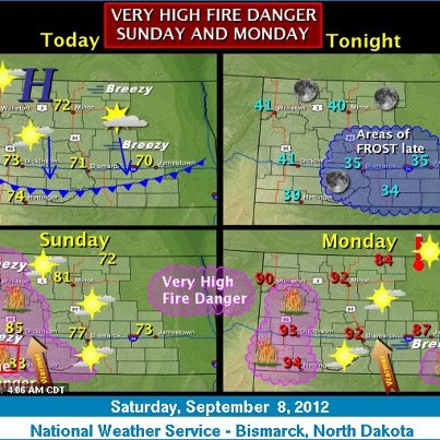
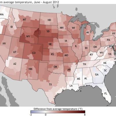
- ...Record Heat and Lack of Precipitation for Portions of the Western U.S...
August 2012 was the hottest August on record at Salt Lake International Airport (SLC). The average temperature was 81.7 degrees, eclipsing the previous record of ...80.8 degrees set in 2004. Additionally, June-August 2012 was the second hottest on record (79.2 degrees), trailing only June-August 2007 (79.3 degrees).See More
Today is the 47th consecutive day with no measurable precipitation at Seattle-Tacoma International Airport (SEA-TAC). This represents the second longest dry streak on record. The longest is 51 days, which would be tied on September 11 (next Tuesday). However, a system moving on shore late in the weekend brings the possibility of rain Sunday and Monday. Also, August 2012 was the driest August on record at SEA-TAC (Trace); the previous driest August was 1974 (0.01").
Graphic courtesy of NWS Salt Lake City, Utah.
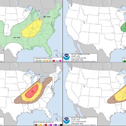
- Potentially Significant Damaging Wind Event Forecast for Much of Northeastern U.S. on Saturday
The NWS Storm Prediction Center is forecasting a potentially significant damaging wind event across much of the northeastern U.S. on Saturday. Latest model guidance suggests that severe thunderstorms will develop across the northern Mid-Atlantic region into New England during the afternoon and evening hours. SPC is indicating a Moderate Risk for severe thunderstorms from northern Maryland and Delaware, across eastern Pennsylvania and New York state and into Vermont and New Hampshire. Details...
http://www.spc.noaa.gov/products/outlook/day2otlk.html
- Today's severe weather threat, from the NWS Storm Prediction Center...
- Heat Continues Across South, Cooler Temperatures in Store for Central U.S.
The heat and humidity continues for the southern Plains and lower Mississippi Valley, where heat index values will likely be in the 105-110 degree range on Friday a...fternoon. Temperatures will begin to cool across the region this weekend. Meanwhile, temperatures will drop by 10 to 15 degrees on Friday across a large portion of the central U.S., as a cold front pushes towards the east. Details...See More
http://go.usa.gov/RRX
- ...Dangerous Heat Impacting Portions of the South...
Hot temperatures and high humidity will again push heat index values to between 105 and 110 degrees on Friday afternoon. The high heat index will make some outdoor activities dangerous b...y increasing the risk of heat related illness. Take extra precautions if you work or spend time outside in this area. Temperatures will begin to cool this weekend.See More
Details...
http://www.hpc.ncep.noaa.gov/discussions/hpcdiscussions.php?disc=pmdspd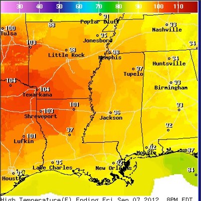
- Hurricane Leslie, the sixth hurricane of the Atlantic hurricane season, is producing swells could result in rip currents along the East Coast through the weekend. Pay attention to signs warning about rip currents and check with lifeguards before entering the water. Be aware and learn to “break the grip of the rip.” Details...
http://1.usa.gov/oMyM8c
http://www.ripcurrents.noaa.gov/
- Severe Weather Possible Across Parts of Plains, Ozarks, Great Lakes and New England
The NWS Storm Prediction Center has updated its outlook for severe weather for Thursday afternoon evening and is now forecasting a risk of severe thunderst...orms for parts of the central and southern Plains, the Ozarks, and parts of the lower Great Lakes and northern New England. The primary threats will be large hail and damaging wind. Details...See More
http://go.usa.gov/Rvk
- Michael Becomes the First Category Three Hurricane of the Season
Hurricane Michael — currently in the central Atlantic, about 980 miles south-southwest of the Azores — has strengthened to Category 3 to become the first major hurricane of t...he 2012 Atlantic season. Maximum sustained winds are near 115 mph and Michael is a small, but powerful, hurricane, with hurricane force winds extending outward about 15 miles from the center, and tropical storm force winds extending outward up to 70 miles.See More
There are no coastal watches or warnings in effect and Michael is not expected to impact the U.S. Details...
http://www.nhc.noaa.gov/#MICHAEL
More info. on image posted below:
http://www.nnvl.noaa.gov/MediaDetail2.php?MediaID=1180&MediaTypeID=1
- El Niño conditions are likely to develop this month, according to the El Niño Watch issued today by the National Weather Service's Climate Prediction Center. More info...
http://www.cpc.ncep.noaa.gov/products/analysis_monitoring/enso_advisory/ensodisc.html
- Severe Weather Possible Thursday Afternoon and Evening Across Parts of Great Plains and Upper Midwest
The NWS Storm Prediction Center is forecasting a risk of severe thunderstorms Thursday afternoon and evening across portions of the centr...al and southern Plains and the Upper Midwest. The area at risk stretches from the northern panhandle of Texas across much Kansas, eastern Nebraska, and Iowa, and into extreme northwestern Illinois. Strong wind, with damaging gusts, and large hail are the primary threats. The greatest threat, especially for hail, will be from central and northern Kansas into southern Nebraska through the evening hours. Details...See More
http://go.usa.gov/Rvk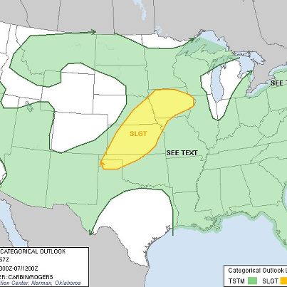
- Severe Storms Moving Through Kentucky and Tennessee
A Severe Thunderstorm Watch is in Effect for portions of southeast Illinois, southeast Indiana, west-central Kentucky, and southwest Ohio until 11pm. A severe squall line is moving south...east through KY and TN this evening. Hail up to 1.5 inches and wind gusts up to 70 mph are possible with this line. Persons in these ares should be on the lookout for threatening weather and possible warnings. Details...See More
http://go.usa.gov/rV2G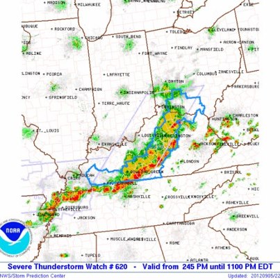
- Leslie Strengthens into the Sixth Hurricane of the Atlantic Hurricane Season
Tropical Storm Leslie intensified and has become Hurricane Leslie. At 1:45 pm EDT the center of Hurricane Leslie was about 465 miles south-southeast of Bermuda. L...eslie is moving slowly toward the north at 2 mph. A general slow north-northwestward motion is expected during the next several days and Leslie may impact Bermuda later this weekend. Maximum sustained winds have increased to 75 mph, with higher gusts. Leslie is forecast to continue to continue to strengthen for the next 48-72 hours. There are currently no Watches or Warnings issued in relation to Hurricane Leslie. Details...See More
http://www.nhc.noaa.gov/#LESLIE
- Strong Early Autumn Storm Brings Damaging Winds to Portions of Southern Alaska
Strong winds from a Bering Sea storm impacted portions of southern Alaska, from the Aleutians to south-central Alaska, Tuesday evening through the overnight hou...rs. Winds of 50-60 mph were prevalent in Anchorage, with gusts to over 100 mph observed just east of Anchorage in the higher elevations.See More
The combination of wet ground and full leaves on the trees led to numerous fallen trees and power outages in the Anchorage area. The wind has subsided thorough much of the region, but power and communications remain down. Details...
http://www.arh.noaa.gov/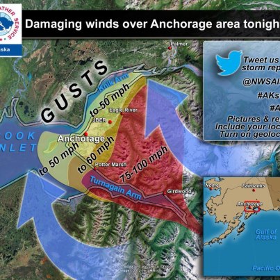
- If Chicago hits 90 today they will tie a record for the most 90-degree days in a year (47). Details:
http://1.usa.gov/Lrd9Z3
Latest forecast for Chicago:
http://1.usa.gov/OTan0K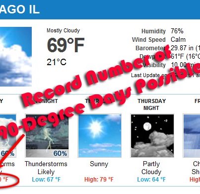
- Severe Thunderstorms Possible on Wednesday from Great Lakes to Lower Mississippi Valley
The NWS Storm Prediction Center is forecasting a risk of severe thunderstorms Wednesday afternoon and evening for parts of the Great Lakes across the O...hio and Tennessee Valleys and into northern Mississippi. The main threats will be large hail and damaging wind, especially for parts of Indiana and Illinois. Details...See More
http://go.usa.gov/Rvk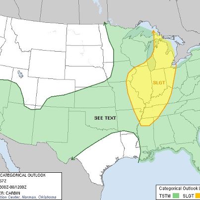
- ...Monsoonal Flow Brings Storms to the Desert Southwest...
Monsoonal moisture surging into the Desert Southwest region of the U.S. is bringing showers and thunderstorms to the arid region. Heavy rainfall on the dry ground brings a risk for localized flooding in the region along with gusty winds and blowing dust. Details...
http://go.usa.gov/rms5
- ...Exceptional Heat Affecting the South-Central U.S. Today...
Temperatures in excess of 100 degrees, with heat indices approaching 110, are scorching the South-Central portions of the country today. Heat advisories stretch from Southeaste
...rn Kansas to Northern Louisiana and Western Mississippi. The heat peaks today but temperatures are expected to remain above average until later in the week. These conditions can quickly bring on heat-related illness. During these conditions, stay out of the sun, drink plenty of fluids, and stay in air-conditioned buildings when possible. Details...See More
http://www.nws.noaa.gov/os/heat/index.shtml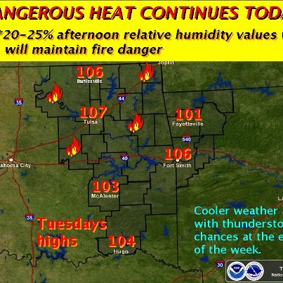
- Tropical Storm Michael Forms in the Eastern Atlantic, No Threat to Land
Tropical Depression Thirteen intensified and has become Tropical Storm Michael. At 11:00 AM EDT the center of newly-formed Tropical Storm Michael was located near abou...t 1,220 miles southwest of the Azores.See More
Michael is moving toward the north-northwest at about 5 mph. A general slow northward motion is expected during the next two days, keeping the cyclone over the eastern Atlantic waters. Maximum sustained winds are near 40 mph, with higher gusts. No significant change in strength is forecast during the next 48 hours. Details...
http://www.nhc.noaa.gov/#MICHAEL
- Risk of Severe Weather Across Upper Midwest, Eastern Great Lakes and North-Central Gulf Coast
The NWS Storm Prediction Center is forecasting a risk of severe thunderstorms for Tuesday afternoon and evening across parts of the Upper Midwest...— from eastern Nebraska to northern Michigan — as well as parts of the eastern Great Lakes — including northeastern Ohio, western Pennsylvania and New York — and the north-central Gulf Coast. The main threat with any developing storms will be large hail, especially for the Upper Midwest, and damaging wind. Details...See More
http://go.usa.gov/Rvk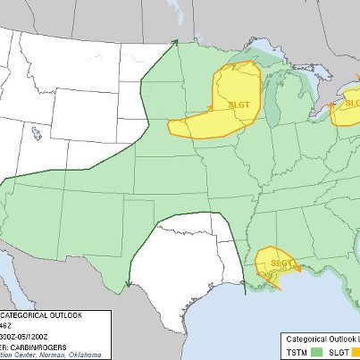
- ...New Tropical Depression forms in the Atlantic Basin...
The Atlantic Hurricane season remains quite active and a new Tropical Depression has formed in the Central Atlantic. The National Hurricane Center began issuing advisories on Tropi...cal Depression 13 as of 5 pm today. TD 13 is a small system currently located about 1350 miles to the west-northwest of the Cape Verde Islands. Some slight strengthening to minimal Tropical Storm status is forecast in the next day or two before increasing wind shear is expected to weaken the system to a remnant area of low pressure. Tropical Depression 13 is not forecast to have any impacts on the United States. Details...See More
http://www.nhc.noaa.gov/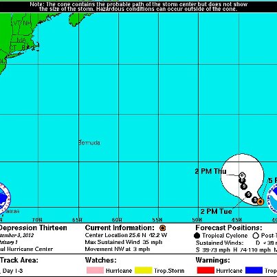
- ...Heat Advisories in Effect for Portions of the South Central United States...
High temperatures on Monday across the southern Great Plains into the Lower Mississippi River Valley will range from the middle 90s to the lower 100s. The comb...ination of heat and high humidity will create dangerous conditions across portions of southeast Kansas into eastern Oklahoma as well as much of Arkansas and northern Louisiana, where heat index values will approach 110 degrees. Heat Advisories have been posted for these areas. Persons with outdoor activities should stay alert to the signs of heat exhaustion and be sure to follow extreme heat safety tips.See More
Safety Tips: http://www.ready.gov/heat
Graphic depicts forecast high temperatures on Monday across the south central United States.
- ...Locally heavy rainfall expected for the Ohio Valley, Mid-Atlantic and into the Southeast through Monday...
Areas of heavy rain and strong thunderstorms will continue to be associated with the post-tropical circulation of Isaac the as its low center moves very slowly eastward across the Ohio Valley.
U.S. National Weather Service shared a link.
...Flash Flood Warning Remains in Effect Until 9am CDT for Central St. Tammany Parish...
The St. Tammany Parish Office of Emergency Management and the Corps of Engineers continue to review the structural integrity of the Pearl River Divers...ion Canal Lock and Dam Number Two which is damaged and could potentially fail. Heavy scour has taken place alongside the relief sill but pressure has been relieved some overnight. Persons and interests in this warned area should not return until the local officials give the all clear.See More- ...Isaac Dominates 7-Day Rainfall Graphic...
While Isaac's impacts were certainly greatest along the Gulf Coast in Louisiana and Mississippi, the tropical system has had far-reaching throughout much of the Eastern United States.
You can s...ee Isaac's rainfall on this 7-day observed precipitation graphic from the Advanced Hydrologic Prediction Service. Far in advance of landfall, Isaac brought flooding rains to Southern Florida and even indirectly to Coastal South Carolina. After moving inland, Isaac has brought beneficial rains to drought stricken areas of the Mississippi River Valley. Details...See More
http://go.usa.gov/rEgC
- ...Major Flooding Continues in Southeast Louisiana and Southern Mississippi...
Although the significant rains from Isaac have diminished along the Gulf Coast, several rivers continue to experience major flooding. The hydrograph seen here ...is the gauge along the Bogue Chitto River near Tylertown, Mississippi. Major flooding is expected through this evening and should drop below flood stage sometime on Sunday. Most other rivers in the region will experience a similar reduction in water levels.See More
Remember: Do not drive cars through flooded area. Two feet of rushing water can carry away most vehicles, including pickups. Turn Around Don't Drown!
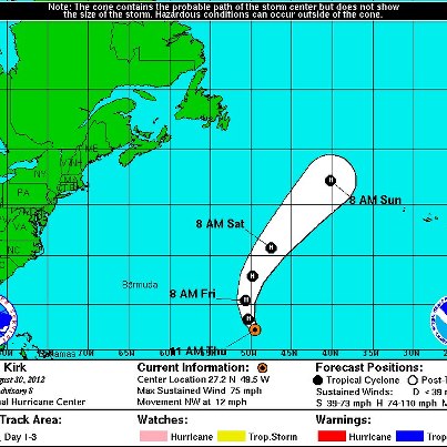
- After Isaac, Still Active an Active Atlantic Tropical Basin
Following Hurricane Isaac and it's impact on the Gulf Coast and into the Mississippi Valley, the National Hurricane Center is still tracking 2 tropical cyclones in the Atlantic Ba...sin. Hurricane Kirk and Tropical Storm Leslie are currently churning through the Atlantic. Unlike Isaac, neither Kirk nor Leslie are currently forecast to impact the United States. Hurricane Kirk is currently weakening as it moves northward, well to the east of Bermuda, with maximum sustained winds of 90 mph. Tropical Storm Leslie is in the strengthening stage and could become a hurricane in the next day or two as it moves to the northwest in the Central Atlantic.See More
Leslie, formed on August 30, is the 2nd-earliest forming 12th-named storm on record in the Atlantic Basin. Only Luis, in 1995, formed earlier, on August 27. Details...
http://go.usa.gov/rEcP
- Tropical Depression Isaac Bringing Heavy Rainfall, Threat of Flash Flooding, to Mid-Mississippi Valley
Flood and flash flood watches and warnings are in effect for parts of Arkansas, southern Mississippi and southeastern Louisiana. The sys...tem is expected to continue moving northward into the mid-Mississippi Valley on Friday before turning northeastward into the Ohio Valley on Saturday. For information specific to your area, including possible watches and warnings, please refer to your local National Weather Service office. Details...See More
http://1.usa.gov/Px23o9
- The NWS Storm Prediction Center is forecasting a risk of severe thunderstorms today for eastern Arkansas and southern Missouri, as Tropical Depression Isaac moves over the area.
Severe thunderstorms are also possible this afternoon and evening across parts of New England and New York state in association with a cold front that is diving southward through the area. Details...
http://go.usa.gov/Rvk
- A magnitude 7.9 earthquake off the coast of the Philippines has prompted the NWS Pacific Tsunami Warning Center to issue a Tsunami Watch for the state of Hawaii, effective 2:57 AM HST.
Based on available data, a tsunami may have been gener...ated by this earthquake that could be destructive on coastal areas.See More
An investigation is underway to determine if there is a tsunami threat to Hawaii. If so, the first tsunami wave is estimated to arrive at 12:28 PM HST. Details...
http://1.usa.gov/S52rQA
The graphic below shows the location of the earthquake off the Philippines.
- Tropical Depression Isaac Bringing Heavy Rainfall and Threat of Flash Flooding to Lower Mississippi Valley
Tropical Depression Isaac will bring heavy rain and the threat of flash flooding as it continues moving northward across the lower M...ississippi Valley and into the mid-Mississippi Valley on Friday before turning northeastward into the Ohio Valley by Saturday night. An additional 3 to 5 inches of rain — with localized amounts as high as 8 inches — will be possible for much of the lower to mid-Mississippi Valley through late Saturday. The heavy rain will spread into the Ohio Valley and portions of the Tennessee Valley on Sunday. By Sunday night into Monday and Tuesday, heavy rains will reach the central Appalachians. For information specific to your area, including possible watches and warnings, please monitor products issued by your local National Weather Service office. Details...See More
http://1.usa.gov/OMSSB2
- Slow-Moving Isaac Weakens To Tropical Depression Over Northern Louisiana
Maximum sustained winds with Isaac have decreased to about 35 mph and Isaac has been officially downgraded to a tropical depression. All coastal warnings have been di...scontinued. However, flooding rains continue across southeastern Louisiana and Mississippi. For storm information specific to your area, please monitor products issued by your local national weather service forecast office. Details...See More
http://www.nhc.noaa.gov/#ISAAC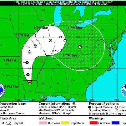
- Data from NOAA buoy 41041 and satellite images show that Tropical Depression Twelve has become a tropical storm — Leslie. Maximum sustained winds are now 40 mph, with higher gusts. According to the National Hurricane Center, no change to th...e track or intensity forecast is required at this time. Details...See More
http://www.nhc.noaa.gov/#LESLIE
This is the second-earliest formation of the 12th named storm on record in the Atlantic basin, eclipsed only by Luis of 1995.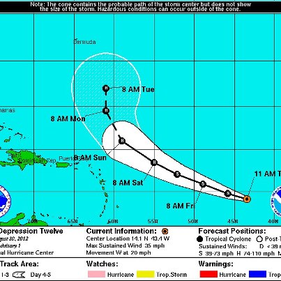
- New graphic from the NOAA Environmental Visualization Lab shows four storms in the tropical Atlantic and eastern Pacific — Tropical Storm Isaac, Hurricane Kirk , Tropical Depression Twelve (now Tropical Storm Leslie) and Hurricane Ileana — at various stages of development. Details...
http://www.nnvl.noaa.gov/MediaDetail2.php?MediaID=1174&MediaTypeID=1
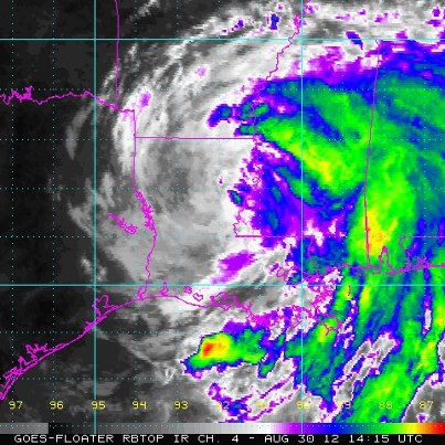
- Tropical Storm Isaac Continues To Drench Southeastern Louisiana And Mississippi With Heavy Rainfall As It Moves Slowly Inland
At 1:00 PM CDT, the center of Tropical Storm Isaac was located about 25 miles southwest of Monroe, La., with maxi...mum sustained winds near 40 mph. Isaac is forecast to continue weakening as it moves inland over the next 48 hours and is expected to become a tropical depression Thursday afternoon or night. Life-threatening hazards from storm surge, inland flooding and tornadoes are still occurring, however. Stay tuned to NOAA Weather Radio, your local NWS forecast office and local news media for impacts affecting your area.See More
http://www.nhc.noaa.gov/#ISAAC