NOAA NWS Storm Prediction Center
is on Facebook.
To connect with NOAA NWS Storm Prediction Center, sign up for Facebook today.
Sign UpLog In
Cover Photo
NOAA NWS Storm Prediction Center - Norman, OK

NOAA NWS Storm Prediction Center
39,968 likes · 756 talking about this

  1. While there is still a lot of uncertainty with regards to where Sandy will come ashore late this weekend/early next week...there are things you can do now to begin preparing for potential impacts.
    Our latest forecast models continue to indicate that Sandy will impact the northeast early next week, including our area. We want to stress that now is the time to monitor and prepare for these possibilities, but not panic. We are still many days away from the storm. To help you prepare we have some suggestions on this graphic on what you can do. Please share this information with others.
    Photo: Our latest forecast models continue to indicate that Sandy will impact the northeast early next week, including our area.  We want to stress that now is the time to monitor and prepare for these possibilities, but not panic.  We are still many days away from the storm.  To help you prepare we have some suggestions on this graphic on what you can do.  Please share this information with others.
  2. Hurricane Sandy is forecast to brush the Southeast coast through the weekend. Thereafter, model forecasts have been trending westward with the eventual forecast track of Hurricane Sandy, potentially bringing it to the Northeast early next w...
    eek. This system will continue to be monitored closely.

    For latest information on Sandy:
    http://www.nhc.noaa.gov/

    For information on thunderstorms and some increase in convective wind potential over Florida east coast through Friday:
    http://www.spc.noaa.gov/products/outlook/

    For information on rainfall:
    http://www.hpc.ncep.noaa.gov/
    See More
    The majority of computer models have trended toward bringing the system north into the Atlantic just off of the Eastern Seaboard and taking a sharp left turn, ultimately moving into the Northeast. Where exactly the system will go remains up...
    in the air. Models are showing the storm entering New Brunswick to as far south as southern NJ. More info as we get it and we will be following this extremely close over the next 3-4 days. Please share this graphic to keep family and friends informed.
    See More
    Photo: The majority of computer models have trended toward bringing the system north into the Atlantic just off of the Eastern Seaboard and taking a sharp left turn, ultimately moving into the Northeast. Where exactly the system will go remains up in the air.  Models are showing the storm entering New Brunswick to as far south as southern NJ.  More info as we get it and we will be following this extremely close over the next 3-4 days. Please share this graphic to keep family and friends informed.
  3. Offshore winds will bring a critical fire weather threat to the coastal ranges and foothills of southern California, including the metro areas of San Diego and Los Angeles.
    Surface high pressure building over the Great Basin will bring gusty offshore winds Thursday evening through Friday night. Areas in the High Wind Warning will see northeast winds increase to 30 to 40 mph Thursday evening in the favored pass...
    es and canyons, with peak gusts to 60 mph Friday morning. The strong winds will continue into Friday afternoon�then slowly subside Friday night. Gusty winds and low relative humidity will lead to elevated fire weather conditions through Saturday.
    See More
    Photo: Surface high pressure building over the Great Basin will bring gusty offshore winds Thursday evening through Friday night. Areas in the High Wind Warning will see northeast winds increase to 30 to 40 mph Thursday evening in the favored passes and canyons, with peak gusts to 60 mph Friday morning. The strong winds will continue into Friday afternoon�then slowly subside Friday night. Gusty winds and low relative humidity will lead to elevated fire weather conditions through Saturday.‎
  4. Sandy has been upgraded to a hurricane, and is forecast to brush the southeast coast through the weekend. Considerable uncertainty exists with the forecast track early next week, with some models suggesting it will progress northwestward to...
    wards the northeastern U.S., while others suggest it will move offshore. The system is being monitored closely by forecast offices, and residents along these areas should continue to monitor the system as well. For more information, visit the National Hurricane Center website: http://www.nhc.noaa.gov/
    See More
    Photo: Sandy has been upgraded to a hurricane, and is forecast to brush the southeast coast through the weekend. Considerable uncertainty exists with the forecast track early next week, with some models suggesting it will progress northwestward towards the northeastern U.S., while others suggest it will move offshore. The system is being monitored closely by forecast offices, and residents along these areas should continue to monitor the system as well. For more information, visit the National Hurricane Center website: http://www.nhc.noaa.gov/
  5. Strong winds will support a critical fire weather threat across northeastern NM, the TX/OK panhandles, southeastern CO and far southwestern KS. A heightened threat of fire spread will also exist over portions of the southwest.

    http://www.spc.noaa.gov/products/fire_wx/fwdy1.html
    Photo: Strong winds will support a critical fire weather threat across northeastern NM, the TX/OK panhandles, southeastern CO and far southwestern KS. A heightened threat of fire spread will also exist over portions of the southwest.

http://www.spc.noaa.gov/products/fire_wx/fwdy1.html
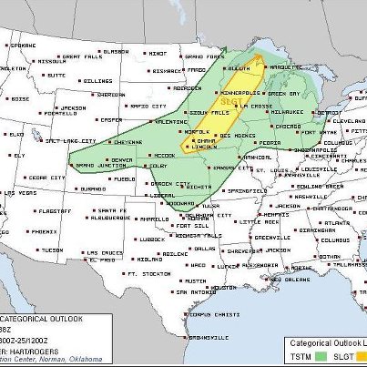
  6. A few supercells and even tornadoes are possible late this afternoon into the evening across portions of the slight risk area. Thereafter, the storms are expected to quickly evolve into a line, producing heavy rainfall and occasionally large hail into the overnight hours.
    Photo: A few supercells and even tornadoes are possible late this afternoon into the evening across portions of the slight risk area. Thereafter, the storms are expected to quickly evolve into a line, producing heavy rainfall and occasionally large hail into the overnight hours.
  7. Critical fire weather conditions are expected today and tomorrow across portions of the southern High Plains. Above normal temperatures will combine with windy and dry conditions...elevating fire danger.

    For more details, see our fire weather outlooks: http://www.spc.noaa.gov/products/fire_wx/overview.html
    Photo: Critical fire weather conditions are expected today and tomorrow across portions of the southern High Plains. Above normal temperatures will combine with windy and dry conditions...elevating fire danger.

For more details, see our fire weather outlooks: http://www.spc.noaa.gov/products/fire_wx/overview.html
  8. A few high-based severe thunderstorms capable of producing hail and damaging winds are possible after sunset over portions of southwest TX.
    Photo: A few high-based severe thunderstorms capable of producing hail and damaging winds are possible after sunset over portions of southwest TX.
  9. The NWS Customer Satisfaction Survey has been extended through October 21. If you have not had a chance to provide your valuable feedback and would like to, you now have through Sunday! This year, there is a special section of the survey on SPC products and services. We appreciate your feedback!

    http://svy.cfigroup.com/launch/NWS/Default.aspx
  10. A Severe Thunderstorm Watch has been issued for portions of southern and eastern MO and a small part of southwest IL until 8PM CDT. Wind gusts to 70mph, 1 inch or larger hail and dangerous lightning are possible with storms in the watch area.

    http://www.spc.noaa.gov/products/watch/ww0666.html
    Photo: A Severe Thunderstorm Watch has been issued for portions of southern and eastern MO and a small part of southwest IL until 8PM CDT.  Wind gusts to 70mph, 1 inch or larger hail and dangerous lightning are possible with storms in the watch area.

http://www.spc.noaa.gov/products/watch/ww0666.html
  11. A strong storm system will bring a threat of both severe weather and critical fire weather conditions today. Severe weather is expected across the middle and lower Mississippi Valley today into tonight. Strong winds and a few tornadoes are...
    possible in addition to some hail.

    Further west...critical fire weather conditions will develop behind a cold front across portions of the central Plains. Very strong winds and low relative humidity will combine with ongoing drought resulting in high fire danger.

    For more details see our Outlook products: http://www.spc.noaa.gov/products/
    See More
    Photo: A strong storm system will bring a threat of both severe weather and critical fire weather conditions today.  Severe weather is expected across the middle and lower Mississippi Valley today into tonight. Strong winds and a few tornadoes are possible in addition to some hail. 

Further west...critical fire weather conditions will develop behind a cold front across portions of the central Plains. Very strong winds and low relative humidity will combine with ongoing drought resulting in high fire danger.

For more details see our Outlook products: http://www.spc.noaa.gov/products/
  12. Severe weather potential will shift eastward today toward the Ohio and Tennessee Valleys. While strong/damaging winds will be the main threat this afternoon and evening...a few tornadoes and some hail are also possible. For more details, see our Day 1 Convective Outlook: http://www.spc.noaa.gov/products/outlook/day1otlk.html
    Photo: Severe weather potential will shift eastward today toward the Ohio and Tennessee Valleys. While strong/damaging winds will be the main threat this afternoon and evening...a few tornadoes and some hail are also possible. For more details, see our Day 1 Convective Outlook: http://www.spc.noaa.gov/products/outlook/day1otlk.html
  13. An extensive slight risk for severe thunderstorms producing large hail and damaging winds is forecast today through tonight across the central states. The greatest threat is highlighted in the 30% damaging wind probability (in red), where a few tornadoes are also expected in the 5% probability (in brown).
    Photo: An extensive slight risk for severe thunderstorms producing large hail and damaging winds is forecast today through tonight across the central states. The greatest threat is highlighted in the 30% damaging wind probability (in red), where a few tornadoes are also expected in the 5% probability (in brown).
  14. Today's primary severe weather risk is forecast for the southern High Plains and Four Corners areas with large hail, severe wind gusts, and a few tornadoes possible. A slight risk continues for Saturday over a large portion of the central U.S. and a slight risk has been introduced for Sunday in parts of the OH/TN Valleys. Please see http://www.spc.noaa.gov/products/outlook/ for further information on any of these outlooks.
    Photo: Today's primary severe weather risk is forecast for the southern High Plains and Four Corners areas with large hail, severe wind gusts, and a few tornadoes possible. A slight risk continues for Saturday over a large portion of the central U.S. and a slight risk has been introduced for Sunday in parts of the OH/TN Valleys. Please see http://www.spc.noaa.gov/products/outlook/ for further information on any of these outlooks.
  15. Slight risks of severe thunderstorms are forecast for today through Saturday across parts of the central U.S. The primary risk on day 1 is for large hail tonight. The highest severe probabilities are forecast on Saturday in parts of the MO and MS River Valleys. See http://www.spc.noaa.gov/products/outlook/day3otlk.html for further information.
    Photo: Slight risks of severe thunderstorms are forecast for today through Saturday across parts of the central U.S. The primary risk on day 1 is for large hail tonight. The highest severe probabilities are forecast on Saturday in parts of the MO and MS River Valleys. See http://www.spc.noaa.gov/products/outlook/day3otlk.html for further information.
  16. While the potential for thunderstorms is expected to increase across the southern tier of the lower 48 states today and Thursday (Day 1: http://www.spc.noaa.gov/products/outlook/day1otlk.html and Day 2: http://www.spc.noaa.gov/products/outl...
    ook/day2otlk.html
    ), an increase in the threat for severe storms will be greatest on Friday and Saturday (refer to graphics below).
    Friday: http://www.spc.noaa.gov/products/outlook/day3otlk.html
    Saturday: http://www.spc.noaa.gov/products/exper/day4-8/
    See More
    Photo: While the potential for thunderstorms is expected to increase across the southern tier of the lower 48 states today and Thursday (Day 1: http://www.spc.noaa.gov/products/outlook/day1otlk.html and Day 2: http://www.spc.noaa.gov/products/outlook/day2otlk.html), an increase in the threat for severe storms will be greatest on Friday and Saturday (refer to graphics below).
Friday: http://www.spc.noaa.gov/products/outlook/day3otlk.html
Saturday: http://www.spc.noaa.gov/products/exper/day4-8/
  17. Much of the lower 48 states will be void of thunderstorms today, given the recent intrusion of cold stable air into the country. An increase in thunderstorm chances will begin on Wednesday from CA and the Great Basin eastward through the southern plains to lower Mississippi valley.
    Photo: Much of the lower 48 states will be void of thunderstorms today, given the recent intrusion of cold stable air into the country.  An increase in thunderstorm chances will begin on Wednesday from CA and the Great Basin eastward through the southern plains to lower Mississippi valley.
  18. A critical fire weather threat is expected across southern WY and portions of NE, IA, and south-central MN as strong winds align with warm temperatures and dry conditions. Any fires that start may spread quickly.
    Photo: A critical fire weather threat is expected across southern WY and portions of NE, IA, and south-central MN as strong winds align with warm temperatures and dry conditions. Any fires that start may spread quickly.
  19. Unusually dry conditions persist across the Pacific Northwest. Gusty easterly winds and warm and dry weather will lead to a critical fire weather threat over portions of south-central WA, north-central and northwestern OR through tomorrow.

    http://www.spc.noaa.gov/products/fire_wx/overview.html
    Dry weather expected through Sunday.
    Photo: Dry weather expected through Sunday.
  20. The annual National Weather Service Customer Satisfaction Survey is available until Friday, October 5th. We appreciate your input to inform us about what we're doing right or what we need to improve!

    Please take 15 minutes to give us your valuable feedback!

    http://svy.cfigroup.com/launch/NWS/Default.aspx
  21. While there is little threat for severe weather today, critical fire weather conditions are expected over several areas from the Northern Plains into the Rockies. Very dry conditions and gusty winds will result high fire danger today across these areas. For more information see our Day 1 Fire Outlook: http://www.spc.noaa.gov/products/fire_wx/fwdy1.html
    Photo: While there is little threat for severe weather today, critical fire weather conditions are expected over several areas from the Northern Plains into the Rockies.  Very dry conditions and gusty winds will result high fire danger today across these areas. For more information see our Day 1 Fire Outlook: http://www.spc.noaa.gov/products/fire_wx/fwdy1.html
  22. A slight risk of severe storms exists today through tonight in parts of the Southeast. The threats include the possibility of a few tornadoes and isolated damaging winds.
    Photo: A slight risk of severe storms exists today through tonight in parts of the Southeast. The threats include the possibility of a few tornadoes and isolated damaging winds.

Earlier in October

Earlier in 2012