Ileana was a strong tropical storm that briefly threatened the southwest
coast of mainland Mexico and the southern tip of the Baja California
peninsula before abruptly turning away from Baja California and dissipating
over open water.
Synoptic history
Tropical Storm Ileana originated from a tropical wave that emerged from the
coast of Africa on 1 August. The wave tracked westward across the tropical
North Atlantic and produced very little convection until 9 August when the
wave reached the western Caribbean Sea. The wave continued to track across
Central America and southern Mexico and eventually emerged over the eastern
Pacific Ocean on 12 August. By 13 August, a low-level cyclonic circulation
was detected in both conventional and QuikSCAT (1221 UTC) satellite data
about 100 n mi south of Manzanillo, Mexico, and the disturbance was
designated a tropical depression. Early on the 14th, the depression
was upgraded to Tropical Storm Ileana based on a Dvorak satellite intensity
estimate of 35 kt.
Ileana tracked northwestward, parallel the west coast of Mexico, and reached
a peak intensity of 60 kt early on 15 August when it was located about 90 n
mi southeast of Cabo San Lucas, Mexico, on the southern tip of Baja
California. The peak intensity was maintained for 18 h, followed by slow
weakening due to a combination of increasing vertical shear and cooler
sea-surface temperatures. Ileana made an abrupt turn to the west and passed
just south and southwest of the southern tip of Baja California on 15 August
as a tropical storm with 60 kt winds. Tropical Storm Ileana weakened to a
depression late on 16 August and dissipated by early 17 August. However, the
remnant broad low-level circulation persisted as a swirl of low clouds until
20 August while tracking westward.
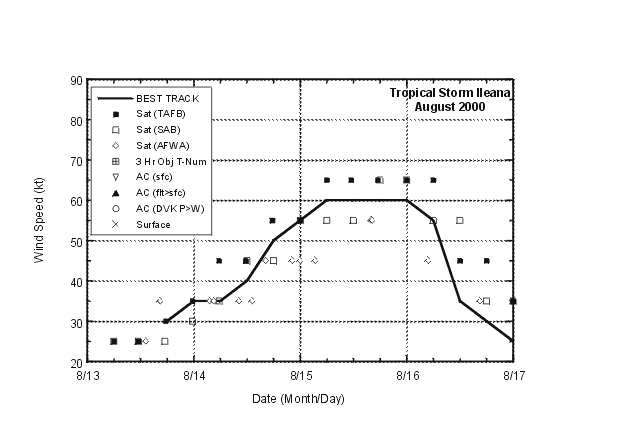
Meteorological statistics
The "best track" of Ileana is given in
Table 1 and Figure 1.
Figure 2 and Figure 3
show the best track maximum sustained (1 min average) surface (10 m
elevation) wind speed and minimum central pressure, as well as the
associated observations. These include Dvorak satellite technique position
and intensity estimates from the Tropical Analysis and Forecast Branch
(TAFB), the NOAA/NESDIS Satellite Analysis Branch (SAB), and the Air Force
Weather Agency (AFWA). Ship NMRY (Golden Bear) reported a pressure of
1008.4 mb and a wind of 35 kt from the south-southwest at 0000 UTC, 15
August, at a location about 40 n mi southeast of the center.
NASA QuikSCAT satellite data (Fig. 4)
provided useful information during Ileana's the early formative stage. An
overpass near 1221 UTC 13 August showed that the circulation had become
better defined just off the southwest coast of Mexico. Even though some of
the QuikSCAT winds indicated speeds of ranging from 35 to 50 kt (tropical
storm strength), they were rain-flagged and the reliability of
rain-contaminated winds is still uncertain. The lone 40 kt wind (purple
color) that was not rain-flagged was missed by the QuikSCAT
Multidimensional Histogram (MUDH) algorithm based on comparisons with
infrared and other microwave data, and was not considered representative of
the maximum winds associated with this system at that time.
Casualty and Damage Statistics
Although Ileana remained well offshore the central west coast of Mexico, the
storm center passed just south of the southern tip of Baja California.
Although large waves associated with the storm likely affected portions of
the these coasts, no reports of damage or casualties were received by the
National Hurricane Center.
Forecast and Warning Critique
Since Ileana was a tropical storm for less than 72 h, no verification
statistics are available for that time interval. However, the NHC official
average track forecast errors were 31, 52, 56 and 54 n mi at 12 (9 cases),
24 (7 cases), 36 (5 cases) and 48 h (3 cases), respectively. These errors
are considerably smaller than the 1990-1999 average of 37, 69, 101 and 132 n
mi. A few of the objective aids had slightly lower forecast errors than the
official forecast at 12 and 24 h, whereas the official forecast errors were
considerably better than all of the objective aids at 36 and 48 h.
NHC intensity forecast errors were near the 1990-1999 average at 12 and 24 h
and worse than the average at 36 and 48 h. There was a positive bias (winds
overforecast) in all of the forecasts, but especially in the 36 and 48 h
forecasts.
Table 2
lists the watches and warnings associated with Ileana. A tropical storm
warning was in effect for a portion of the coast of Mexico from Lazaro
Cardenas to Cabo Corrientes from the time Ileana became a tropical
depression at 2100 UTC 13 August until 1500 UTC on 14 August, when the
cyclone moved away from the west coast of mainland Mexico. However, at the
latter time, a tropical storm warning and a hurricane watch were issued for
the southern Baja California Peninsula from La Paz southward around the
peninsula to Todos Los Santos. They remained in effect until 0300 UTC on 15
August, at which time a hurricane warning was issued for the same area and
a tropical storm warning was issued for the remainder of the Baja Peninsula
south of 25N latitude. At 2100 UTC on 15 August, all warnings were
discontinued while Ileana moved westward away from the southern tip of the
Baja Peninsula after reaching its closest point of approach about 45 n mi
south and southwest of Cabo San Lucas on the 15th.
Table 1.
Best track, Tropical Storm Ileana, 13-17 August 2000.
Date/Time
(UTC) | Position |
Pressure
(mb) |
Wind Speed
(kt) | Stage |
| Lat. (°N) | Lon. (°W) |
| 13 / 1800 | 17.1 | 104.0 | 1005 | 30 | tropical depression |
| 14 / 0000 | 17.7 | 104.7 | 1004 | 35 | tropical storm |
| 14 / 0600 | 18.4 | 105.6 | 1003 | 35 | " |
| 14 / 1200 | 19.1 | 106.4 | 1000 | 40 | " |
| 14 / 1800 | 19.9 | 107.0 | 998 | 50 | " |
| 15 / 0000 | 20.8 | 107.6 | 992 | 55 | " |
| 15 / 0600 | 21.5 | 108.5 | 991 | 60 | " |
| 15 / 1200 | 22.0 | 109.5 | 991 | 60 | " |
| 15 / 1800 | 22.1 | 110.6 | 991 | 60 | " |
| 16 / 0000 | 22.3 | 111.5 | 992 | 60 | " |
| 16 / 0600 | 22.5 | 112.5 | 994 | 55 | " |
| 16 / 1200 | 22.7 | 113.1 | 1000 | 35 | " |
| 16 / 1800 | 23.0 | 113.6 | 1005 | 30 | tropical depression |
| 17 / 0000 | 23.3 | 114.5 | 1007 | 25 | " |
| |
| 15 / 0600 | 21.5 | 108.5 | 991 | 60 | minimum pressure |

Figure 1.
Best track positions for Tropical Storm Ileana, 13-17 August 2000.

Figure 2.
Best track maximum sustained 1-minute 10 meter surface wind speed curve for
Tropical Storm Ileana, 13-17 August 2000.

Figure 3.
Best track minimum central pressure curve for Tropical Storm Ileana, 13-17
August 2000.

Figure 4.
NASA QuikSCAT overpass of Tropical Storm Ileana near 1221 UTC 13 August
2000 when the system was near tropical depression intensity just off the
southwest coast of Mexico. Image courtesy of NOAA/NESDIS Marine Observing
Systems Team. Black wind barbs indicate unreliable wind speeds due to
heavy rain contamination.
Table 2.
Watch and warning summary for Tropical Storm Ileana, 13-17 August 2000.
Date/Time
(UTC) |
Action |
Location |
| 13/2100 | Tropical Storm Warning issued | Lazaro Cardenas to Cabo Corrientes along the southwest coast of Mexico |
| 14/1500 | Tropical Storm Warning canceled | Lazaro Cardenas to Cabo Corrientes along the southwest coast of Mexico |
| 14/1500 | Tropical Storm Warning and Hurricane Watch issued | La Paz to southward to Todos Los Santos on the southern Baja Peninsula of Mexico |
| 15/0300 | Hurricane Warning issued | La Paz to southward to Todos Los Santos on the southern Baja Peninsula of Mexico |
| 15/0300 | Tropical Storm Warning issued | Remainder of the Baja California Peninsula south of 25N latitude |
| 15/2100 | Hurricane Warning and Tropical Storm Warning canceled | All of the Southern Baja California Peninsula |
![[NCEP Logo]](graphics/ncep.gif)