MINT
– the MMS Intertidal Team
MMS biologists on the MINT team continue to
support the study of rocky intertidal communities along the coast of
California (maps).
The MMS Intertidal Team, or MINT, is one of nine
monitoring teams that collect data for MARINe
 , the Multi-Agency
Rocky Intertidal Network
MARINe.gov. MINT biologists team up with biologists from five
university campuses (UC Santa Cruz, UC Santa Barbara, UCLA, UC Davis,
and California State University Fullerton) to monitor mussels, sea
stars, algae, and other intertidal plants and animals along the coast.
, the Multi-Agency
Rocky Intertidal Network
MARINe.gov. MINT biologists team up with biologists from five
university campuses (UC Santa Cruz, UC Santa Barbara, UCLA, UC Davis,
and California State University Fullerton) to monitor mussels, sea
stars, algae, and other intertidal plants and animals along the coast.
MINT has been active since 1991, when MMS, the
County of Santa Barbara and scientists at UC Santa Barbara set up
shoreline inventory sites at nine locations from Vandenberg AFB to
Carpinteria. MMS funds 24 sites along the mainland, from San Luis Obispo County to Orange County. MMS
sponsors university biologists to conduct the monitoring and
coordinate MARINe projects. MINT
biologists monitor turf algae, rockweed, acorn and goose barnacles,
mussels, surf grass, sea stars, black abalone, limpets, and motile
invertebrates (crabs and snails) along the mainland at MMS-funded
sites. The National Park Service and many other organizations monitor
MARINe sites on the islands and other sections of the mainland (see
MARINe.gov for information on the other MARINe partners).
In addition to providing field support twice a
year at MMS-funded sites, the MINT team leads special projects for
MARINe, including reviews of protocols, development of new techniques,
equipment development; and sponsoring an annual Taxonomic Workshop for
MARINe field teams.
Special
projects:
The MINT team worked with UCLA to test aerial photography methods for use in
sampling rocky intertidal communities. They tested an
unmanned18 foot blimp and a remote-controlled mini-helicopter (below).
Both are remotely-controlled by a joystick from the ground.
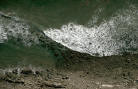
In a separate survey, the State
of California, Office of Spill Prevention and Response flew 4 MMS
sites with their winged aircraft while shots at several
hundreds of feet above the site put the MMS sites in perspective with
other rocky formations along the coast (see below).
University Scientists working with MINT:
Four key scientists have been instrumental in
shaping the work being done in rocky intertidal habitats along our
coast. Dr. Pete Raimondi (University of California,
Santa Cruz); Dr. Rich Ambrose (UCLA), Dr. Jack Engle (UC Santa
Barbara) and Dr. Steve Murray (California State University at
Fullerton) (left to right below) have worked with MMS and other
biologists to develop the sampling approaches and monitoring
strategies that have become the basis of MARINe. Countless hours of
effort have been put in by these scientists studying, analyzing, and
working to understand the dynamics of the rocky intertidal habitats
off our coast.
These scientists, their technicians, and students
have monitored MMS-funded sites in the field with MINT
biologists since 1991. The success of a long term monitoring program
such as this is due in large part to the consistency of effort
provided by technicians dedicated to accurate, systematic collection
of data.
Mussel Recovery Study:
The MMS Intertidal Team (MINT) has studied rocky
intertidal communities since 1991. MINT continued the MMS-funded long
term study of four rocky intertidal communities in northern and
central California from 1985-1998 to determine the recovery time
needed for mussel beds following a major disturbance.
 |
 |
 |
|
MINT team members collect data at a central California site in
1998. MINT team members are
pictured with Melissa Wilson (UCSC) and Dick Wilhelmsen (former
MMS manager) after a day of work. A point intercept sampling method
is used to determine dynamics of disturbed mussel beds.
|
Shoreline Inventory
Study:
From 1991 to 2000, MINT members, with the help of
then UCSB scientists Rich Ambrose, Pete Raimondi, Jack Engle and their
technicians Jessie Altstatt and Melissa Wilson, collected data at the
Santa Barbara County mainland sites as part of the MMS/County of Santa
Barbara Shoreline Inventory Study. These data have been placed into
the MARINe database.
MINT is
funded directly by MMS as an in-house study.
Web Master:
Nollie
Gildow-Owens
Page content last updated 5/24/2010
Page last published 5/24/2010