Skip Navigation Link


Ocean Products


Aerosol | Coral Bleaching | Ocean Color | Sea/Lake Ice | Sea Surface Height |
Sea Surface Temperatures | Tropical Systems | Winds

Aerosol

Sample Aerosol Optical Thickness

Detailed Product Information

Operational Products
Aerosol Optical Thickness (100Km Global Analysis)
Daily Analysis
8-Day Composites
8-Day Composites (1.6 Micron)
Monthly Mean
GOES Aerosol Smoke Product (GASP)
GASP-East AOD and ASDTA Smoke AOD
GASP-West AOD
GOES Biomass Burning Emissions Product (GBBEP)  East | West

Coral Bleaching

Sample Coral Bleaching Hotspots

Detailed Product Information

Operational Products
Coral Bleaching Virtual Stations
Degree Heating Week Charts
HotSpots
SST Anomaly Charts
SST Nighttime Field Image Charts

Ocean Color

Sample Ocean Color Image

Detailed Product Information
Operational Products
Chlorophyll Concentration
MERIS - Daily | Bi-Monthly Mean | Anomaly
MODIS/Aqua - Daily | Bi-Monthly Mean | Anomaly
SeaWiFS - Daily | Bi-Monthly Mean | Anomaly
Ocean Color (Remote Sensing Reflectance)
MODIS/Aqua (667 nm) - Daily | Bi-Monthly Mean | Anomaly
SeaWiFS (670 nm) - Daily | Bi-Monthly Mean | Anomaly
Harmful Algal Bloom Bulletins (National Ocean Service and NESDIS)
CoastWatch site (Alternative site - Coastal Services Center)

Developmental Products
Chlorophyll Concentration
MODIS/Terra - Daily | Bi-Monthly Mean | Anomaly

Ocean Color (Remote Sensing Reflectance)
MERIS (665 nm) - Daily | Bi-Monthly Mean | Anomaly
MODIS/Terra (667nm) - Daily | Bi-Monthly Mean | Anomaly

Some of these products have restricted access (More Information).


Sea/Lake Ice

Sample MSPPS Ice Coverage Image

Detailed Product Information
Operational Products
Sea Ice Concentration
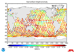
MIRS | MSPPS - (Orbital, Mapped) | SSM/I


Sea Surface Heights

Sample Sea Surface height anomaly

Detailed Product Information
Developmental Products
Sea Surface Height Anomaly
Product Information Handbook Link (PDF 1.13 Mb)
Significant Wave Height
Product Information Handbook Link (PDF 1.13 Mb)


Sea Surface Temperatures

Sample Sea Surface Temperature Image

Detailed Product Information

Operational Products
CoastWatch SST (POES)
SST Anomaly Charts
SST Contour Charts Text or Thumbnails
SST Images
SST Nighttime Field Image Charts
SST Monthly Mean

Developmental Products
CoastWatch SST (GOES)
CoastWatch MODIS L2 SST

Tropical Systems

Tropical Systems

Detailed Product Information

Operational Products
Advanced Dvorak Technique - Objective Tropical Storm Classifier
Ensemble Tropical Rainfall Potential (eTRaP)
Tropical Bulletins
Tropical Cyclone Formation Probability Product
Tropical Storm Position and Intensity

Developmental Products
Multi-Platform Tropical Cyclone Surface Winds Analysis (MTC-SWA)

Satellite Imagery
Atlantic Ocean and Gulf of Mexico
Geostationary Satellite Server - Hurricane Sectors
Operational Significant Event Imagery - Tropical Events
Pacific Ocean
Tropical Floaters

Winds

Sample TRaP Image

Detailed Product Information
Operational Products
High Density IR Cloud Drift Winds
High Density Visible Winds
High Density Water Vapor Winds
Ocean Surface Winds:
Jason-2 Winds (OSTM) Information - Handbook Link (PDF 1.13 Mb)
QuikSCAT Winds
Wind Speed (SSM/I)


Contact Information:
You are Here: http://www.osdpd.noaa.gov/ml/ocean/index.html
 
OSDPD Webmaster