 |
 |
 |
 |
 |
 |
 |
 |
 |
 |
 |
 |
 |
 |
 |
 |
 |
 |
 |
 |
GOES Sea Surface Temperature Product Overview
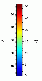
NOAA CoastWatch provides sea surface temperature (SST) products derived from NOAA's Geostationary Operational Environmental Satellites (GOES). The Office of Satellite Data Processing and Distribution generate operational SST retrievals from the GOES 11 and 12 satellite imagers. These two satellites are situated at 135 degrees W longitude and 75 degrees W longitude, respectively, thus allowing the acquisition of high-temporal-resolution SST retrievals. A new cloud masking methodology based on a probabilistic (Bayesian) approach has been implemented for improved retrieval accuracy. This new GOES SST Bayesian algorithm provides SST retrievals with an estimate of the probability of cloud contamination. This indicates the confidence level of the cloud detection for the retrieval, which can be related to retrieval accuracy. The GOES-11 and 12 imagers observe both northern and southern hemisphere every half an hour. These 5-band (0.6, 3.9, 6.7, 10.7, 12 or 13.3 micron) and 4-band (0.6, 3.9, 6.7, 10.7. or 13.3 micron) images are processed to retrieve SST retrievals at 4-km resolution. The infrared channels determine the SST, and all channels (except the 6.7 and 13.3 �m) determine the cloud contamination. These retrievals are remapped, averaged and composited hourly and made available for users to access. NOAA CoastWatch accesses these sea surface temperature (SST) products and puts them into the CoastWatch HDF format for the users. Available through this website are 3�hour and 24�hour averages for the coastal United States. Image information is found in the product's file naming convention and information sidebar or banner. The colorbar (as illustrated to the right) shows the relationship between colors shown in the image and temperature. The following information is from a typical sidebar: Product Type: Sea Surface Temperature
|
 |
|
|||||
|


