


 Rapid Update Cycle Model Data (RUC)
Information updated on December 3, 2008, 9:08 pm GMT
General Data Description
The Rapid Update Cycle (RUC) is an operational atmospheric prediction system comprised primarily of a numerical forecast model and an analysis system to initialize that model. Mesoscale Analysis and Prediction System (MAPS) is the research counterpart to the RUC. The RUC has been developed to serve users needing short-range weather forecasts. RUC runs operationally at the National Centers for Environmental Prediction (NCEP).The key features of RUC/MAPS include:
- high-frequency (every 1h) 3-d objective analyses over the contiguous United States
- high-frequency (every 1h) short-range weather model forecasts (out to 12 h) in support of aviation and other mesoscale weather forecast users
- assimilation of data from
- commercial aircraft (relayed through ACARS - Aircraft Communications, Addressing, and Reporting System)
- wind profilers (404 and boundary-layer 915 MHz)
- rawinsondes and special dropwinsondes
- surface reporting stations and buoys
- RASS (Radio Acoustic Sounding System) - experimental
- VAD (velocity-azimuth display) winds from NWS WSR-88D radars
- GOES total precipitable water estimates
- SSM/I total precipitable water estimates
- GPS total precipitable water estimates
- GOES high-density visible and IR cloud drift winds
The RUC uses a hybrid isentropic-sigma vertical coordinate in which most of the atmosphere is resolved on isentropic surfaces (defined by constant virtual potential temperature) except for layers near the ground where terrain-following (sigma) coordinates are used.
Over the period of time that ARM has been collecting RUC data, the resolution has improved from 60 to 40 to 20 to 13 kilometeters
ARM archives only the hourly analysis data not the forecasts.
 Expand All
 Collapse All
Data Stream Names
- allruc20hybr - Rapid Update Cycle (RUC) model: hybrid analysis data, 20-km resolution
netCDF File Header Description (Data Object Design File) - allruc20isob - Rapid Update Cycle (RUC) model: isobaric main analysis data, 20-km resolution
netCDF File Header Description (Data Object Design File) - allruc40hybr - Rapid Update Cycle (RUC) model: hybrid analyisis data, 40 km resolution
netCDF File Header Description (Data Object Design File) - allruc40isob - Rapid Update Cycle (RUC) model: isobaric main analysis data, 40-km resolution
netCDF File Header Description (Data Object Design File) - allruc60 - Rapid Update Cycle (RUC) model: output, 60 km resolution
netCDF File Header Description (Data Object Design File) - fslruc60 - Rapid Update Cycle (RUC) model: FSL output, 60 km resolution
netCDF File Header Description (Data Object Design File) - ruc20hybr - Rapid Update Cycle (RUC) model: daily hybrid analysis data, 20 km resolution
netCDF File Header Description (Data Object Design File) - ruc20isob - Rapid Update Cycle (RUC) model: daily isobaric analysis data, 20 km resolution
netCDF File Header Description (Data Object Design File) - ruc60 - Rapid Update Cycle (RUC) model: output, 60 km grid covering Southern Great Plains
netCDF File Header Description (Data Object Design File) - synruc20isob - Rapid Update Cycle (RUC) model: isobaric output, 20 km grid, averaged to 40 km
netCDF File Header Description (Data Object Design File)
Measurement Description
Temporal Coverage
| Data Stream Name | Start Date | End Date |
|---|---|---|
| RUC netCDF | ||
| sgpfslruc60X1.c0 | 10/24/1994 | 11/16/1994 |
| sgpallruc60X1.c0 | 05/08/1996 | 04/23/1998 |
| sgpruc60X1.c1 | 05/08/1996 | 04/23/1998 |
| sgpallruc40hybrX1.c1 | 12/04/1998 | 4/16/2002 *** |
| sgpallruc40isobX1.c1 | 04/20/1998 | 4/16/2002*** |
| sgpallruc20hybrX1.c1& | 4/18/2002 | 10/16/2002** |
| sgpallruc20isobX1.c1& | 4/18/2002 | 10/16/2002** |
| pyeruc20isobX1.c1 & | 3/1/2005 | current* |
| sgpruc20hybrX1.c1 & | 4/18/2002 | current* |
| sgpruc20isobX1.c1 & | 4/18/2002 | current* |
| sgpsynruc20isobX1.c1 & | 4/18/2002 | current* |
| RUC GRIB Input files from FSL | ||
| sgpallruc40hybrX1.00 | 12/04/1998 | 4/16/2002 *** |
| sgpallruc40isobX1.00 | 04/20/1998 | 4/16/2002 *** |
| sgpallruc20hybrX1.00 | 4/18/2002 | current* |
| sgpallruc20isobX1.00 & | 4/18/2002 | current* |
| sgpfnnallruc20isobX1.00 & | 4/18/2002 | current* |
| sgpallruc13hybrX1.00 | 02/21/2008 | current* |
| sgpallruc13isobX1.00 & | 02/01/2008 | current* |
Notes:
*Current RUC 20 data are available at the ARM Archive approximately 4 days after
they are generated.
& Beginning on 6/28/2005, the RUC20 GRIB and resulting cdf files are "look-alike" files generated from the RUC13 files.
** Although the sgpallruc20* netCDF files are no longer at the ARM Archive, they are still generated at the XDC and are kept for one month after generation for special needs. Contact Richard Wagener if these files are needed.
*** For RUC40 data from 19991209 - 20020416, hour 23Z is usually missing. The reason for these gaps is unknown.
Area Covered
- RUC60
- The 60-km grid has 81 by 62 points.
- RUC40
- The 40-km grid (AWIPS grid ID 236) has 151 by 113 points.
- RUC20
- The 20-km grid (AWIPS grid ID 252) is 301 by 225.
- RUC13
- The 13-km grid (AWIPS grid ID 130) is 451 by 337.
RUC-20 and RUC-13 have 50 computational levels compared to 40 levels for the RUC-40.
The files named sgpallruc20* cover the entire RUC domain.
The files named pyeruc20isobX1.c1 cover latitudes 34.300 to 42.539
and longitudes -127.607 to -120.862.(see map)
The files named sgpruc20* are "cropped" to cover latitudes from 34.21 to 38.93
and longitudes from -100 to -95. (see map)
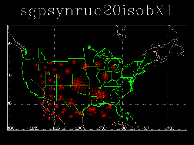
The files named sgpsynruc20isobX1.c1 have reduced resolution (grid cells are
averaged to 40 km resolution) and cover latitudes from 25 to 45 and longitudes from -115 to -85. (see map)
Data Stream Inputs
sgpf00allruc60X1.00
sgpfnnallruc60X1.00
sgpallruc60X1.00
RUC-40
sgpfnnallruc40isobX1.00
sgpfnnallruc40hybrX1.00
sgpallruc40hybrX1.00
sgpallruc40isobX1.00
RUC-20
sgpfnnallruc20isobX1.00
sgpfnnallruc20hybrX1.00
sgpallruc20hybrX1.00
sgpallruc20isobX1.00
RUC-13
sgpallruc13hybrX1.00
sgpallruc13isobX1.00
Notification Form Link
Related Links
Contacts
- ARM Mentor Shaocheng Xie
- ARM Software Developer Laurie Gregory
Data Source
Reprocessing History
- Reprocessing Date In February, 2003 data was reprocessed spanning dates 19980421 - 19980930.
- Start End Reprocessing 19980421 - 19980930
- Reason Reprocessing 19980421 - 19980930 reprocessing: Reprocessing completed: Data from 19980421 - 19980930 were reprocessed and corrected. Corrected data were sent to the Archive on 2003-02-07.
Reason data was reprocessed:The sgpallruc40isobX1.c1 data from 1998-04-21 to 1998-09-30 originally archived was incorrect. The data contained all missing values (-9999). The error was due to unexpected GRIB header information in the GRIB data files. From 1998-04-21 to 1999-02-16, the grid number was given as 255 (undefined) when the ingest expected it to be 236. Starting 1999-02-16, cycle 13Z, FSL changed the grid number to 236. Since the 1998 GRIB data are correct and there was a simple work-around to the ingest, the data were reprocessed to correct the output data.
FAQ
- Q: Can I get the forecast data?
- A: The forecast data are only collected when the analysis data are unavailable for some reason. This is a very rare occurrence and for all intents and purposes the forecast data should be considered unavailable.
- Q: What is the difference between the sgpallruc20isobX1.00 and sgpallruc20hybrX1.00 datastreams?
- A:
The sgpallruc20isobX1.00 are isobaric files. The sgpallruc20hybrX1.00 are
hybrid. The hybrid data uses a combination of two types of vertical
coordinates - isentropic and sigma. Hybrid is short for
"hybrid-b isentropic-sigma coordinate".
Additional information is available at: http://maps.fsl.noaa.gov/tpbruc.cgi#2.1
Technical Procedures Bulletin : http://ruc.fsl.noaa.gov/ppt_pres/RUC20-tpb.pdf
http://ruc.fsl.noaa.gov/
- Q: I need RUC data outside of the SGP CART domain. How can I get it?
- A: The full RUC domain is archived only in GRIB format and
is available by emailing the desired datastream name and time period
to the archive armarchive@arm.gov
For research relevant to ARM and for large requests or requests requiring data in netCDF format, please fill out a "Special Data Set Request". - Q: How can I create subsetted RUC 40 data similar to the RUC 20 data currently available at the Archive?
- A:Currently, the RUC 40 netCDF data available at the archive are the full area, hourly files (sgpallruc40isobX1.c1 and sgpallruc40hybrX1.c1). Using the netCDF Operator (NCO) utilities, it is easy to produce subsetted, daily files similar to the RUC 20 subsets available (sgpruc20hybrX1.c1 and sgpruc20isobX1.c1).
The NCO utilities can be found at http://nco.sourceforge.net/
Using the ncks (NCO "kitchen sink") command, you can subset the ruc data as follows:
ncks -d nx,<xmin >,<xmax> -d ny,<ymin>,<ymax> <input_file> <output_file>

Note: xmin,xmax,ymin,ymax are index ranges.

For example to subset around the SGP site use the following index values
for latitudes 34.209 to 38.928 and longitudes -99.798 to -95.
xmin = 71
xmax = 82
ymin = 40
ymax = 53
ncks -d nx,71,82 -d ny,40,53 sgpallruc40isobX1.c1.20000314.130000.cdf sgpruc40isobX1.c1.subset.cdf
Here is a sample C-Shell script for subsetting the ruc40 and using the NCO command ncrcat to concatenate the hourly subsetted files into a ruc 40 subsetted daily file similar to the sgpruc20isobX1.c1 files.
#!/bin/csh
# This script subsets the RUC 40 isobaric files
# and then concatenates hourly files into 1 daily file
# usage: subset_ruc40.csh <yyyymmdd>
#   where yyyymmdd is the date of the files to subset
#   and concatenate. Ex. 20000314 (yyyy=2000,mm=03, dd=14)
# Example: subset_ruc40.csh 20000314
# xmin,xmax,ymin,ymax are indices for
# lat = 34.209, 38.928, lon = -99.798, -95
set xmin = 71
set xmax = 82
set ymin = 40
set ymax = 53
set date = $1
foreach file (sgpallruc40isob*$date*)
  ncks -d nx,${xmin},${xmax} -d ny,${ymin},${ymax} $file $file.sub
end
ncrcat -h sgpallruc40isob*$date*sub sgpruc40isobX1.c1.$date.000000.cdf
rm *.sub
exit
For more information on the NCO commands ncks and ncrcat see:
http://nco.sourceforge.net/nco.html#ncks-netCDF-Kitchen-Sink
http://nco.sourceforge.net/nco.html#ncrcat-netCDF-Record-Concatenator
Also other commands for subsetting and analysis of netCDF data can be found at http://www.arm.gov/data/tools.stm
- Q: Why does the preciprate (or PRATE) parameter contain all zeros or missing values?
- A:
The following two answers are from Stan Benjamin from the ESRL/GSD RUC forum:
http://ruc.fsl.noaa.gov/forum/eval/
Question 1: from http://ruc.fsl.noaa.gov/forum/f2/Welcome.cgi/read/1180
Jim submitted the following question on 2004-01-28:
The F00 (analysis) set of GRIB products for the RUC (at NCEP and FSL) contain precip grids which are valid over some interesting time periods. One is an accumulation over two times which are the same (an instantaneous accumulation?) and the other looks like it is the one-hr accumulation ending at the current time, as it has t0 = 23 and t1 = 0. For the instantaneous accumulation, the large-scale precip field values are all 0, and the convective precip fields are all -99999. For what looks like the 1-hr accumulation (t0=23, t1=0) the values are 99999 for both precip types. Is there any chance that real values can be sent for these grids, especially the ones that look like the 1-hr accumulation anding at the analysis time? Thanks!Answer: Stan answered the question on 2004-01-29:
Jim and everyone, The 0h RUC precip fields are basically carried over from the previous 1h forecast used as a background for the current analysis. They should not be regarded as a precipitation analysis. There is some information on convection based on GOES passed through the 1h convective precip to help trigger the RUC convective parameterization the next hour, but again, it shouldn't be used as a precip analysis. Good question.
Stan Benjamin
Question 2: from http://maps.fsl.noaa.gov/forum/eval_archive/?read=1518
Posted by Mike on 29 Aug 02, 8:19 MT:
Hello,
As I am not a meteorologist I was hoping some one could explain the PRATE parameter? I am looking for precipation information that will enable me to display up to six levels of weather. This is the weather that is commonly seen on a weather radar. If PRATE can't do this is there a parameter or combination of parameters in RUC that can?
Thanks.
Answer: Posted by Stan Benjamin on 9 Sep 02, 12:04 MT, in response to PRATE explanation, posted by Mike on 29 Aug 02, 8:19 MT:
Mike,
The PRATE field from the RUC is an instantaneous precipitation rate. The 1-h precipitation would be another candidate field for your application. It is possible to convert 3-d hydrometeor mixing ratios for rain, snow, and graupel into estimated reflectivities, but that probably goes beyond what you need.
I hope this helps.
Stan
Data User Notes
If you have determined you need to order the GRIB format data, send e-mail to armarchive@ornl.gov including datastream names and time period that you require.
Note that on 2/1/2008, the format for the GRIB files changed from GRIB1 to GRIB2. Information on reading GRIB1 and GRIB2 formatted files can be found at: Reading netCDF, HDF, and GRIB Files
Acronyms
| FSL | Forecast Systems Laboratory |
| GRIB | GRIdded Binary |
| MAPS | Mesoscale Analysis and Prediction System |
| NCEP | National Centers for Environmental Prediction |
| PYE | Point Reyes |
| RUC | Rapid Update Cycle |
| SGP | Southern Great Plains |
Citable References
Benjamin, S.G., G.A. Grell, J.M. Brown, T.G. Smirnova, and R. Bleck, 2004: Mesoscale weather prediction with the RUC hybrid isentropic / terrain-following coordinate model. Mon. Wea. Rev., 132, 473-494.
S. G. Benjamin, etal. "RUC-2-The Rapid Update Cycle Version 2". NWS Technical Procedures Bulletin No. 448
S. G. Benjamin, etal. (2002)"RUC20 - The 20-km version of the Rapid Update Cycle". NWS Technical Procedures Bulletin No. 490