|
|
|
Metadata
|
|
ID
|
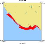
J-2-95-MB
|
|
Abstract
|
Chief Scientists: Roberto Anima, Andy Stevenson, Steve
Eittreim. Geophysical data (sidescansonar, navigation,
bathymetry) of field activity J-2-95-MB in Monterey Bay from
03/06/1995 to 04/15/1995
|
|
Project/Theme
|
Monterey Bay National Marine Sanctuary
|
|
Chief Scientist
|
Roberto Anima
Andy Stevenson
Steve Eittreim
|
|
Activity Type
|
Geophysical
|
|
Platform
|
David Johnston
|
|
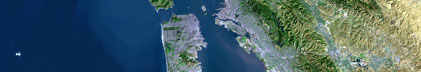
Area of Operation
|
Monterey Bay
|
|
Location map
|
|
|
Bounding Coordinates
|
37.11152
-122.36479 -121.86706
36.91842
|
|
Dates
|
03/06/1995 (JD 065) to 04/15/1995 (JD 105)
|
|
Analog Materials
|
list
|
|
Index map

|
|
|
Crew
|
|
Roberto Anima
|
Chief Scientist, USGS Western Region
|
|
Andy Stevenson
|
Chief Scientist, USGS Western Region
|
|
Steve Eittreim
|
Chief Scientist, USGS Western Region
|
|
|
Equipment Used
|
|
sidescansonar
|
|
navigation
|
|
bathymetry
|
|
|
Notes
|
|
Associated activities:
|
|
|
M-1-93-MB
|
|
|
J-1-94-MB
|
|
|
J-2-95-MB
|
|
J-6-95-MB
|
|
M-2-95-MB
|
|
P-1-95-MB
|
|
P-3-95-MB
|
|
R-1-95-MB
|
|
|
M-1-96-MB
|
|
|
J-1-97-MB
|
|
J-3-97-MB
|
|
|
A-4-98-MB
|
|
J-3-98-MB
|
|
J-4-98-MB
|
|
|
MBMS NEARSHORE STUDIES: In spite of rough seas and nasty weather the David
|
|
Johnston completed 19 out of a scheduled 40 days of high-resolution seismic
|
|
reflection and side-scan surveys along the nearshore coastal area in the
|
|
Monterey Bay Marine Sanctuary between Aptos and Ano Nuevo. Roberto Anima,
|
|
Andy Stevenson, Steve Eittreim, and Jim Tait (UCSC) report that they, with
|
|
support from ETs Mike Boyle and Fred Payne, were able to collect excellent
|
|
records that imaged the extent of submarine outcrops and subbottom
|
|
features. Correlations with coastal bluff exposures were apparent. The
|
|
surveys are part of a continuing program to compile a side-scan sonar
|
|
mosaic of the offshore area of Monterey Bay Marine Santuary. Graduate
|
|
and undergraduate students from U.C. Santa Cruz joined the cruise to observe
|
|
the data collection processes. R. Anima
|
|
|
Publications
|
|
Eittreim, Stephen L., and Noble, Marlene, editors, 2002, Seafloor geology and
|
|
natural environment of the Monterey Bay National Marine Sanctuary: Marine Geology, v. 181
|
|
http://www.sciencedirect.com/
|
|
|
Journals > m > Marine Geology > Volumes 181 - 190 > Volume 181, Issues 1-3
|
|
|
|
Wong, F.L., and Eittreim, S.L., 2001, Continental Shelf GIS for the Monterey
|
|
Bay National Marine Sanctuary: U.S. Geological Survey Open-file Report 01-179,
|
|
1 CDROM,
|
http://geopubs.wr.usgs.gov/open-file/of01-179/
|
|
|
Got Help?
|
For J-2-95-MB, we would appreciate any information on -- contract, days at sea, dive count, funding, information specialist, information to be derived, kms of navigation, national plan, NGDC Info, organization, owner, ports, project number, purpose, scanned materials, seismic description, station count, station description, submersible, summary, tabulated info.
|
|