
Skipanon Channel, Oregon

In tidal waterway extending south 2.7 miles from deep water in Columbia River. Channel enters Columbia about 10 miles above Columbia River Entrance Bar and 4 miles below Astoria, Oregon.
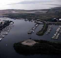
City of Warrenton owns wharf with a 300-foot frontage open to public on equal terms. One privately owned cannery wharf with a 300-foot frontage is used for unloading fish and handling fish nets. One privately owned boatyard has floats and moorage facilities for use by a maximum of 80 small boats. Small-boat basin has facilities for numerous fishing and recreation craft, and a privately owned lumber mill has a barge loading facility for chips and lumber. Facilities are considered adequate for existing commerce.
AUTHORIZED BY:
Rivers and Harbor Act of: 3 Jul 1930, 26 Aug 1937, 30 Jun 1948.
Project Description:
The channel from the Columbia River to the railroad bridge at Warrenton is 1.8 miles long, 200 feet wide, and 30 feet deep.
The turning basin is 30 feet deep.
The mooring basin is 12 feet deep.
Above the railroad bridge, the channel is 4,500 feet long, 40 feet wide (with increased widths at log dumps and terminals), and 6 feet deep.