| 50 |  |
Looking out of town at the outskirts of Zamboanga. |
Philippine Islands, Zamboanga 1926 |
51 |  |
Monday must have been wash day at Zamboanga. |
Philippine Islands, Zamboanga 1926 |
52 |  |
The main street in Zamboanga. |
1926 |
53 |  |
Carabao providing motive power for transportation. |
1926 |
54 |  |
Rural scene a mile out of Jolo. |
Philippine Islands, Jolo 1926 |
55 |  |
Palm trees in the vicinity of the constabulary at Jolo. |
Philippine Islands, Jolo 1926 |
56 |  |
Children greeting a Coast Survey ship upon its arrival in port and begging for coins to be tossed in the water. |
1926 |
57 |  |
A Moro fisherman casting a net in the southern Philippines. |
Philippine Islands, Southern 1926 |
58 |  |
A Moro sapit, a moderate-sized vessel that could be rowed during periods of calm . |
1926 |
59 |  |
When entering Sandakan Harbor it would seem that it is best to keep this rock on the right hand. |
Sandakan, Borneo 1926 |
60 |  |
Taking a cool refreshing bath while loading water for the ship from the Mauo River. Henry Healy on left, Charles Pierce on right. Sure hope it wasn't drinking water! |
1926 |
61 |  |
Moro vinta and the pearling fleet in Jolo Harbor. |
Philippine Islands, Jolo 1926 |
62 |  |
Native sons of most any barrio. |
1926 |
63 | 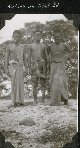 |
Natives on Ticul Island. |
Philippine Islands, Ticul Island 1926 |
64 |  |
A night view of the Manila Carnival. |
Philippine Islands, Manila 1926 |
65 | 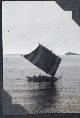 |
A vinta underway. |
1926 |
66 |  |
Small island off Basilan Island near Portholland. |
Philippine Islands, Near Basilan Island 1926 |
67 |  |
Station Par on Laparan Island. Note builders on observing platform at top of tower for scale. |
Philippine Islands, Laparan Island 1927 |
68 |  |
Station Us at Usada Island. |
Philippine Islands, Usada Island 1926 |
69 | 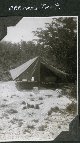 |
An officer's tent at Station Usada. Note all the amenities. |
1926 |
70 |  |
The chow hall at Station Usada. |
1926 |
71 | 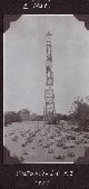 |
Station Dat at Dcatabato Island (spelled Databato in other entries). |
Philippine Islands, Databato Island 1926 |
72 |  |
Tony the cook at a field camp. |
1926 |
73 |  |
A native tribe near Jolo. |
1926 |
74 |  |
Home from market, a Filipina lady balancing her load. |
1926 |
75 |  |
The Chinese pier at Jolo. |
Philippine Islands 1927 |
76 |  |
"The moaning of the tied", a cartoon pasted on the inside cover of a treatise by Julius Erasmus Hilgard "Lecture On Tides" delivered to the American Institute in 1871. The cartoon was drawn by Frank Hudson, a computer in the computing division. |
1871 |
77 |  |
Cover to "Lecture on Tides" by Julius Erasmus Hilgard, delivered to the American Institute on January 27, 1871. |
1871 |
78 |  |
Collar devices for officers of the United States Coast and Geodetic Survey. In: Changes in Uniform Regulations. [Approved by the Secretary of Commerce June 27, 1917.] |
1917 |
79 |  |
Gold lace sleeve stripes for officers of the USC&GS. In: Changes in Uniform Regulations. [Approved by the Secretary of Commerce June 27, 1917.] |
|
80 |  |
Shoulder loops for officers of the USC&GS. In: Changes in Uniform Regulations. [Approved by the Secretary of Commerce June 27, 1917.] |
|
81 |  |
Belt plate, cap device and other uniform paraphernalia of USC&GS. In: Changes in Uniform Regulations. [Approved by the Secretary of Commerce June 27, 1917.] |
|
82 |  |
Coast and Geodetic Survey nautical exhibit. |
1915 Ca. |
83 |  |
Coast and Geodetic Survey geodetic exhibit. |
1915 Ca. |
84 |  |
Coast and Geodetic Survey lithographic printing exhibit. |
1915 Ca. |
85 |  |
Coast and Geodetic Survey lithographic printing exhibit. |
1915 Ca. |
86 |  |
Coast and Geodetic Survey charting exhibit. |
1915 Ca. |
87 |  |
Storage of Coast and Geodetic Survey charts prior to distribution. |
1915 Ca. |
88 |  |
Exhibit of magnetic instruments and operations. |
1920 ca. |
89 |  |
Lines of equal magnetic declination for the year 1850. |
1935 Ca. |
90 |  |
Lines of equal magnetic declination for the year 1875. |
1935 Ca. |
91 |  |
Lines of equal magnetic declination and equal annual change for 1935. |
1935 Ca. |
92 |  |
Location of magnetic observatories in United States and Pacific Ocean. San Juan , Cheltenham, Tucson, Sitka, and Honolulu were Coast and Geodetic Survey magnetic and seismological observatories. |
1935 Ca. |
93 |  |
Galitzin Vertical Component Seismometer and McComb-Romberg tilt compensation seismograph in: Coming to grips with the Earthquake Problem," by Nicholas H. Heck, 1931. Journal of the Franklin Institute, Vol. 212, No. 3, pp. 269-303. |
1930 ca. |
94 |  |
Photographic seismic recorder as illustrated in: "Coming to Grips with the Earthquake Problem," by Nicholas H. Heck, 1931. Journal of the Franklin Institute, Vol. 212, No. 3, pp. 269-303. |
1930 Ca. |
95 |  |
Determination of the epicenter of an earthquake by manual means on a globe of the Earth. In: "Coming to grips with the Earthquake Problem," by Nicholas H. Heck, 1931. Journal of the Franklin Institute, Vol. 212, No. 3, pp. 269-303. |
1930 Ca. |
96 |  |
Map showing "Known Earthquakes of the United States". In: "Coming to grips with the Earthquake Problem," by Nicholas H. Heck, 1931. Journal of the Franklin Institute, Vol. 212, No. 3, pp. 269-303. |
1930 Ca. |
97 |  |
Nautical chart compiler at work. In: "The Coast and Geodetic Survey: Its Products and Services", 1965. 57 pp. |
1965 Ca. |
98 |  |
Aeronautical chart compiler at work. In: "The Coast and Geodetic Survey: Its Products and Services", 1965. 57 pp. |
1965 Ca. |
99 |  |
Negative engaver working on a nautical chart. In: "The Coast and Geodetic Survey: Its Products and Services", 1965. 57 pp. |
1965 Ca. |

