| 2150 |  |
Signal off the Delaware coast. Planted by RANGER |
Delaware coast 1929 |
2151 |  |
A floating signal. Photograph in 1931 Hydrographic Manual |
|
2152 | 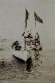 |
Floating signal off the Delaware coast. Party off of RANGER |
Delaware coast 1929 |
2153 |  |
Tautwire measuring machine. By trailing wire astern and counting revolutions, one can determine distances. Used to measure distance between floating hydrographic signals |
New York Bight area 1939 |
2154 |  |
White-washed hydrographic signals in Taku Inlet area. Who says engineers can't be artistic? Signal made by crew off of WESTDAHL |
Taku Inlet area, Alaska 1936 |
2155 |  |
ORCA signal in Taku Inlet. Told tourists in area that signals were native hieroglyphics. Signal made by crew off of WESTDAHL |
Taku Inlet area, Alaska 1936 |
2156 |  |
White-washing hydrographic signals in Alaska. |
1930? |
2157 |  |
Signal party white-washing rock. Party off of EXPLORER |
Rudyerd Bay, Southeast Alaska 1931 |
2158 |  |
White-washing rock. Party off of LESTER JONES |
|
2159 |  |
Preparing white-wash for marking signal. At Station ACT on Amchitka Island. Party off of EXPLORER |
Amchitka Island, Aleutian Islands, Alaska 1949 |
2160 | 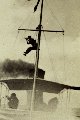 |
Taking sextant angles for positioning vessel. |
|
2161 |  |
Working together for a three-point sextant fix. Note horizontal attitude of sextants |
Southeast Alaska 1916 |
2162 |  |
Calibrating Raydist by using three-point sextant fix. Initial tests of Raydist off of SOSBEE |
Tampa Bay area, Florida 1954 |
2163 |  |
Launch hydrography three-point sextant fix. Surveying lagoon at Kwajalein Island. Party off of PIONEER |
Kwajalein Island, Pacific 1960 |
2164 |  |
Launch hydrography three-point sextant fix. Surveying in vicinity of Kalgin Island. Party off of SURVEYOR |
Kalgin Island, Cook Inlet, Alaska 1967 |
2165 |  |
Wharton and Jeffries taking three-point sextant fix. Surveying in vicinity of Kalgin Island. On SURVEYOR |
Kalgin Island, Cook Inlet, Alaska 1967 |
2166 |  |
Taking three-point sextant fix with check angle. Calibrating electronic navigation system. Third man searching for signal. On NOAA Launch 1255 |
1981 |
2167 |  |
Taking three-point sextant fix with check angle. Calibrating electronic navigation system. On NOAA Launch 1255 |
1981 |
2168 |  |
Checking index error of sextants prior to conducting launch hydrography. |
|
2169 |  |
The tools of the trade for navigating during launch hydrography. Metallic and plastic three-arm protractors for plotting three-point fixes. Sextant in background. 1931 Hydrographic Manual |
|
2170 |  |
Checking boatsheet during wiredrag survey of Mitchell Jordan Reservoir. Plastic three-arm protractor for plotting fixes barely visible under hand. Surveying reservoir for seaplane landing site during WWII ferrying operations. Wiredrag party of Max G. Ricketts |
Mitchell Jordan Reservoir, Alabama 1942 |
2171 |  |
Plotting three-point sextant fix with metallic three-arm protractor. On the FATHOMER |
Philippines 1928 |
2172 |  |
Manual plotting of three-point sextant fix. Using plastic three-arm protractor |
|
2173 |  |
Geometry of the three-point sextant fix. Diagram shows shoreline, stations, and angles measured. 1931 Hydrographic Manual |
|
2174 |  |
Graphic of various combinations of strong and weak three-point fixes. Hydrographic Manual |
|
2175 |  |
Graphic demonstrating Radio Acoustic Ranging (RAR). Developed in 1923, RAR was the first non-visual navigation system. Combined velocity of sound in water with radio to obtain fix. |
Georges Bank 1931 |
2176 |  |
Planting a hydrophone anchor with the cable attached. On the GUIDE. Hydrophone would pick up sound from RAR TNT explosion. |
Cape Blanco area, Oregon 1924 |
2177 |  |
Cable drum being pulled by horses across dunes. Cable lead to offshore hydrophone for Radio Acoustic Ranging. On the GUIDE |
Cape Blanco area, Oregon 1924 |
2178 |  |
Electronics setup for Radio Acoustic Ranging shore station. Navigation station for the GUIDE |
Cape Blanco area, Oregon 1924 |
2179 |  |
Planting anchor for Radio Acoustic Ranging hydrophone. Must have been warm - note bare foot helping push anchor away from ship |
|
2180 |  |
A new type of hydrophone block for Radio Acoustic Ranging. On the GUIDE |
San Clemente Island area, California 1925 |
2181 |  |
Transferring the hydrophone block and cable to launch for planting. Radio acoustic ranging operations on the GUIDE |
San Clemente Island area, California 1925 |
2182 |  |
Launch laying the cable from hydrophone to the shore station. Radio acoustic ranging operations on the GUIDE |
San Clemente Island area, California 1925 |
2183 |  |
Shore Radio Acoustic Ranging Station on San Clemente Island. Radio acoustic ranging operations on the GUIDE |
San Clemente Island area, California 1925 |
2184 |  |
Radio operator at work at Radio Acoustic Ranging shore station KGHS. Radio acoustic ranging operations on the SURVEYOR |
Kodiak Island area, Alaska 1929 |
2185 |  |
The first Odessey Protractor. This instrument was used to plot intersecting ranges from two RAR stations. Invented while Herman Odessey attached to DISCOVERER. Variations of this instrument were used for plotting positions for over 60 years |
1929 |
2186 | 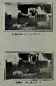 |
Radio Acoustic Ranging bomb making. TNT bombs were sound source for RAR. RAR work on OCEANOGRAPHER |
Georges Bank, New England coast 1930 |
2187 |  |
Radio Acoustic Ranging bomb making. TNT bombs were sound source for RAR. RAR work on OCEANOGRAPHER |
Georges Bank, New England coast 1930 |
2188 |  |
Radio Acoustic Ranging - igniting the bomb and timing fuse. TNT bombs were sound source for RAR. RAR work on OCEANOGRAPHER |
Georges Bank, New England coast 1930 |
2189 |  |
Timing the fuse on a quart bomb during RAR operations. TNT bombs were sound source for RAR. RAR work on OCEANOGRAPHER |
Georges Bank, New England coast 1930 |
2190 |  |
Quart bombs exploding during RAR operations. TNT bombs were sound source for RAR. RAR work on OCEANOGRAPHER |
Georges Bank, New England coast 1930 |
2191 |  |
A schematic view of RAR and echo-sounding. Diagram in public information brochure |
1934 |
2192 |  |
The Launch PRATT - an RAR hydrophone boat. Worked as station boat while HYDROGRAPHER conducted sounding operations |
Morgan City, Louisiana July 1935 |
2193 |  |
A sono-radio-buoy developed to eliminate need for station boats. RAR operations in the Gulf of Mexico. Forerunner of Anti-submarine warfare sonobuoys |
1936 |
2194 |  |
Electronics package of sono-radio-buoy for RAR. This instrument was developed by Almon Vincent on the GUIDE. Forerunner of Anti-submarine warfare sonobuoys |
1936 |
2195 |  |
Sono-radio-buoy for RAR work on pier --- Almon Vincent design. Forerunner of anti-submarine warfare sonobuoys |
|
2196 |  |
Almon Vincent tuning the antenna circuit on sono-radio-buoy. RAR work on the GUIDE |
1936 |
2197 |  |
Railroad car couplers used to anchor RAR hydrophone. On the OCEANOGRAPHER |
1939 |
2198 |  |
Vincent type sono-radio-buoy being deployed from the GUIDE. RAR operations on north coast of Unimak Island |
North coast of Unimak Island, Aleutian Islands 1939 |
2199 |  |
Sono-radio-buoy developed by Almon Vincent for RAR work. Buoy deployed from the GUIDE |
1936 |