| 1500 |  |
Coast Guard Cutter Bear at Demarcation Point. Provided transportation for magnetic field work by C&GS officer J. T. Watkins |
Demarcation Point, Alaska July 1921 |
1501 |  |
Magnetic observations at sea on the C&GS Ship BACHE. |
Atlantic Ocean Ca. 1915 |
1502 |  |
Early use of proton precession marine magnetometer. Deployment of towed magnetometer on C&GS Ship PIONEER |
|
1503 |  |
Brown pendulum apparatus gravity meter. Named for its inventor, Lt. E. J. Brown, C&GS. Lt. Brown died in an automobile accident in 1935. |
1937 |
1504 |  |
Mendenhall half-second pendulums. Figure 2 of William Bowie's "Investigations of Gravity and Isostasy" |
Ca. 1895 |
1505 |  |
Gravity observing apparatus. Figure 3 of William Bowie's "Investigations of Gravity and Isostasy" |
Ca. 1917 |
1506 |  |
Original form of Mendenhall half-second pendulum gravity measuring apparatus. Figure 3 of William Bowie's "Investigations of Gravity and Isostasy" |
Ca. 1895 |
1507 |  |
Ground shaker at Position "B". Used to determine earthquake engineering characteristics of buildings. C&GS was the first organization to undertake engineering seismology studies. Party of William D. Patterson |
California 1937 |
1508 |  |
Building shaker in the doorway of a building. Used to determine earthquake engineering characteristics of buildings. C&GS was the first organization to undertake engineering seismology studies. Party of William D. Patterson |
California 1937 |
1509 |  |
Ground shaker at Position "A". Used to determine earthquake engineering characteristics of buildings. C&GS was the first organization to undertake engineering seismology studies. Party of William D. Patterson |
California 1937 |
1510 |  |
Deployment of towed magnetometer on C&GS Ship PIONEER. |
Pacific Ocean 1964 |
1511 |  |
Bank of recording instruments at Honolulu geophysical observatory. Recording tidal levels at remote sites throughout Pacific Basin. Used for tsunami warning system. |
Honolulu, Hawaii Ca. 1967 |
1512 |  |
Bank of recording instruments at Honolulu geophysical observatory. Recording tidal levels at remote sites throughout Pacific Basin. Used for tsunami warning system. |
Valdez, Alaska 1964 |
1513 |  |
Radical changes in sea level following 1964 Alaska Good Friday Earthquake. |
Valdez, Alaska 1964 |
1514 |  |
Earthquake damage in Alaska following 1964 Good Friday Earthquake |
Southern Alaska 1964 |
1515 |  |
Tsunami damage at Kodiak following 1964 Good Friday Earthquake |
Kodiak, Alaska 1964 |
1516 |  |
Tsunami damage at Seward following 1964 Good Friday Earthquake |
Seward, Alaska 1964 |
1517 |  |
Tsunami damage at Kodiak following 1964 Good Friday Earthquake |
Kodiak, Alaska 1964 |
1518 |  |
Tsunami damage at Seward following 1964 Good Friday Earthquake |
Seward, Alaska 1964 |
1519 |  |
Reproduction of first map showing magnetic declination in the United States. First published by the Coast Survey in 1856 |
1856 |
1520 | 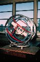 |
Proton vector magnetometer used to measure the absolute value of magnetic field |
Ca. 1967 |
1521 |  |
Proton vector magnetometer used to measure the absolute value of magnetic field |
Ca. 1967 |
1522 |  |
Using a magnetometer to measure the declination. Declination is the angle between true north and magnetic north |
Ca. 1967 |
1523 | 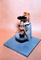 |
Description not available. |
|
1524 |  |
A happy face cactus in the Galapagos Islands. During western hemisphere magnetic project |
Galapagos Islands 1945 |
1525 |  |
I think I'll take this thing for a spin. NOAA diver gets ready for a spin on a tourist moped . At the end of the cruise ship piers in Nassau |
Nassau, Bahamas Islands 1984 |
1526 |  |
Disney eagle originally designed for the Coast and Geodetic Survey |
|
1527 |  |
The joy of kissing the baby. Equator crossing on NOAA Ship MOUNT MITCHELL |
On the Equator in Atlantic Ocean 1990 |
1528 |  |
It is now official. Pizza can be delivered virtually anywhere |
|
1529 |  |
King Neptune dubbing a pollywog an official shellback. The end of the Equator crossing ordeal on a NOAA Ship |
On the Equator in the Atlantic Ocean 1990 |
1530 |  |
Hey Mike, let's try fishing somewhere else. They don't seem to be biting here. Fishermen followed bad advice about where the fish were biting. Building crew off PEIRCE on Eleuthera Island |
Eleuthera Island, Bahamas Islands 1984 |
1531 |  |
Mac Smith - dressed to kill. What hydrographers wear for a night out on the town |
Ca. 1935 |
1532 | 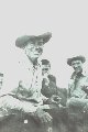 |
Ronnie and Elvis greet geodetic party at Montana dude ranch |
Montana Ca. 1958 |
1533 |  |
A Pinckney Island Industry. Moonshine in the Southeast |
Pinckney Island, South Carolina 1931 |
1534 |  |
The crew of the SURVEYOR playing baseball at Dutch Harbor |
Dutch Harbor, Unalaska Island, Alaska July 4, 1969 |
1535 |  |
Tidal benchmarks under 10 feet of ice. Ensign Sainsbury looks in vain for the 1911 benchmarks |
Chinitna Bay, Cook Inlet area, Alaska April 26, 1956 |
1536 |  |
Baseball at Dutch Harbor - the national pastime goes to the Aleutians |
Dutch Harbor, Alaska July 4, 1940 |
1537 |  |
The rim of the crater of Mt. Erebus. The view from a helicopter |
Mt. Erebus, Antarctica Ca. 1980 |
1538 |  |
Lieutenant Cynthia McFee checking the distances to major cities. Mileage indicator at the South Pole. Lieutenant McFee was the third woman to winter over at the South Pole |
South Pole, Antarctica 1981 |
1539 |  |
Photographer takes self-portrait in South Pole marker. Atmosheric phenomena provide halo for observer |
South Pole, Antarctica 1981 |
1540 |  |
C&GS ship offshore near Rockland, Maine. Conducting observations along the Eastern Oblique Arc |
Near Rockland, Maine 1890's? |
1541 |  |
A small grouper looks glumly at divers installing tide gauge |
Eleuthera Island, Bahamas Islands 1984 |
1542 |  |
Survey launch with Shoran antenna departing PIONEER |
Vicinity of Kiska Island, Aleutian Islands, Alaska 1949 |
1543 |  |
Shoran antenna dismantled prior to launch pickup. Launch off of EXPLORER |
Port Clarence, Alaska 1950 |
1544 |  |
Arctic Field Party hydrographic launch - a converted LCVP |
Beaufort Sea Ca. 1950 |
1545 |  |
Arctic Field Party hydrographic launch - a converted LCVP |
Beaufort Sea Ca. 1950 |
1546 |  |
Lake Survey hydrographic launch |
Great Lakes Ca. 1960 |
1547 |  |
SURVEYOR launches for detached party tied up |
Nome, Alaska 1969 |
1548 |  |
Hydrographic survey launch on a calm day in the South Pacific. Launch off of SURVEYOR - a small boat in a big ocean |
South coast of American Samoa 1971 |
1549 |  |
26' plastic pig running shore line in Pillsbury Sound. Note man on bow watching out for coral heads and rocks. Launch off of WHITING |
South shore of Thatch Cay, U. S. Virgin Islands 1975 |

