| 400 |  |
A view of Tower Falls, Yellowstone National Park. Time for a little touring between jobs. |
Wyoming, Yellowstone National Park |
401 |  |
Dupe of 402 |
|
402 | 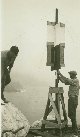 |
Lt. Charles Pierce on left and Jack Bachtel setting up signal on offshore rock. |
California, Big Sur 1932 |
403 |  |
Lt. Charles Pierce at station on offshore rock. |
California, Big Sur 1932 |
404 |  |
Lt. Charles Peirce at station at Soberanes Point at present day Garrapata State Park. |
California, Big Sur 1932 |
405 |  |
A panoramic view of the Ventana Range. |
California, Big Sur 1932 |
406 |  |
Jack Bachtel and Lt. William Tucker putting up a signal on a windy day near the Pt.Pinos Lighthouse at Station Horn. |
California, Pacific Grove 1932 June |
407 |  |
Setting up the theodolite to make observations. |
California, Luce's Point 1932 June |
408 |  |
Floyd Risvold on left, Lt. Charles Pierce pointing "gun", and George Blair recording angle observations. |
California, South of San Simeon 1932 |
409 |  |
Views in the vicinity of Mt. Wass. |
Utah, Near Mt. Wass 1934 |
410 |  |
Views in the vicinity of Mt. Wass. |
Utah, Near Mt. Wass 1934 |
411 |  |
Views in the vicinity of Mt. Wass. |
Utah, Near Mt. Wass 1934 |
412 | 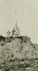 |
Re-occupying an old station that has nearly eroded away. |
California, Southern coast? 1933? |
413 |  |
Main Street of Long Beach, California, the morning after the devasting 1933 earthquake. |
California,Long Beach 1933 March 11 |
414 |  |
A scene in Long Beach the morning after the devastating 1933 earthquake. |
California,Long Beach 1933 March 11 |
415 |  |
A scene in Long Beach the morning after the devastating 1933 earthquake. |
California,Long Beach 1933 March 11 |
416 |  |
A scene in Long Beach the morning after the devastating 1933 earthquake. |
California,Long Beach 1933 March 11 |
417 |  |
A scene in Long Beach the morning after the devastating 1933 earthquake. |
California,Long Beach 1933 March 11 |
418 |  |
A scene in Long Beach the morning after the devastating 1933 earthquake. |
California,Long Beach 1933 March 11 |
419 |  |
A scene in Long Beach the morning after the devastating 1933 earthquake. |
California,Long Beach 1933 March 11 |
420 |  |
A scene in Long Beach the morning after the devastating 1933 earthquake. |
California,Long Beach 1933 March 11 |
421 |  |
Floyd Risvold's letter home describing the Long Beach earthquake destruction of 1933. Envelope sent from Newport Beach. |
|
422 |  |
Page 1 of Floyd Risvold's letter home describing the Long Beach earthquake destruction that he witnessed on March 11, 1933. |
|
423 |  |
Page 1 of Floyd Risvold's letter home describing the Long Beach earthquake destruction that he witnessed on March 11, 1933. |
|
424 |  |
Page 1 of Floyd Risvold's letter home describing the Long Beach earthquake destruction that he witnessed on March 11, 1933. |
|
425 |  |
Plane table with view of tripod head to facilitate leveling and orienting the table. |
|
426 |  |
Cut-away view of plane table with alidade. |
|
427 |  |
Five-lens photogrammetric camera used for aerial photography and mapping in the 1920's and 1930's. |
|
428 |  |
Army aerial photography unit with three-lens camera. Circa 1920's. |
|
429 |  |
Steamer tracks showing relationship of Alaska to Japan and other parts of the Far East. This map also shows virtually the total operating area of the USC&GS including the East and Gulf Coasts of the United States, Puerto Rico, the West Coast, Alaska, and the Philippines. |
|
430 |  |
Salt domes at the edge of the continental shelf in the Gulf of Mexico. Offshore salt domes were first discovered by the United States Coast and Geodetic Survey in the 1930's and properly identified as salt domes by Francis Shepard, the "father of submarine geology" who often worked with the C&GS. |
|
431 |  |
Chart 5101A, first published in 1939, showing contours to be used for contour- following navigation. This was the first chart produced by the C&GS and among the first in the world to have adequate bathymetry for use by mariners as a navigational tool. The data was acquired in the 1930's as the result of radio- acoustic ranging surveys allowing precise positioning far from shore. |
|
432 |  |
Chartlet showing track of PATHFINDER from Aleutians to West Coast at end of 1947 field season. Position 67 is the location of PATHFINDER Seamount, first discovered on this particular track. This seamount is among the larger of the North East Pacific Seamounts. |
|
433 |  |
The fathogram trace of Pathfinder Seamount. |
|
434 |  |
A note from the great C&GS bathymetrist Harold Murray stating that the seamount now known as Pathfinder Seamount was originally meant to be named Studds Seamount, after the commanding officer of the PATHFINDER. Many years later a seamount was named for Captain (ultimately Rear Admiral) Studds. |
|
435 |  |
A three-dimensional plaster (?) model of Gilbert and Patton Seamount groups in the Gulf of Alaska. |
|
436 |  |
A note from Harold Murray of the Coast and Geodetic Survey describing the model in image cgs00435. |
|
437 |  |
The axis of the Aleutian Trench as shown on the recording of an early deep water recording instrument. |
|
438 |  |
Note by Harold Murray describing deepest depth in the Aleutian Trench crossing shown in image cgs00437. The deepest depth was 3585 fathoms in this particular crossing. |
|
439 |  |
Canyon crossing showing v-shaped canyon in the Aleutian Islands. |
|
440 |  |
Profile of continental slope west of Oregon. Note flat area on lower right which is indicative of an abyssal plain. |
|
441 |  |
Note by Harold Murray concerning image cgs00440. Note greatest depth and then compare to image cgs00442. |
|
442 |  |
Profile of continental slope off Oregon approximately 30 miles north of image cgs00440. The extreme flat area offshore is exactly the same depth (1630 fathom s) as the similar flat area on image cgs00440. |
|
443 |  |
Note by Harold Murray describing what is seen in image cgs00442. |
|
444 |  |
Fathometer trace in the vicinity of the Juan de Fuca Ridge area showing many minor knolls rising from the bottom. Subsequently, these features have been shown to be of recent volcanic origin in close proximity to the Juan de Fuca Ridge spreading center. |
|
445 |  |
Note by Harold Murray describing what is seen in image cgs00444. |
|
446 |  |
USC&GS pressman (note logo on shirt) operating guillotine paper cutter prior to using paper for printing charts. |
|
447 |  |
USC&GS pressman (note logo on shirt) operating guillotine paper cutter prior to using paper for printing charts. |
|
448 |  |
See image theb2933 for comparison. |
|
449 |  |
Operating the 50-inch camera designed by Captain Otis Reading, USC&GS. After the compilation drawing is completed, glass plates negatives were made by this precision camera, capable of photographing images up to 50 inches square. The error in reproducing images of this size was less than one thousandth of an inch. |
|

