| 2250 |  |
Electronics for loading Raydist tower. Party off of NOAA Launch 1257 |
Cape San Blas, Florida 1978 |
2251 |  |
Erecting ARGO navigation tower. Party off of MT. MITCHELL |
Louisiana coast 1988? |
2252 |  |
Erecting ARGO navigation tower. Party off of MT. MITCHELL |
Louisiana coast 1988? |
2253 |  |
Erecting ARGO navigation tower. Making final adjustments - not a good job for acrophobics. Party off of MT. MITCHELL |
Louisiana coast 1988? |
2254 |  |
Erecting ARGO navigation tower. Making final adjustments - not a good job for acrophobics. Party off of MT. MITCHELL |
Louisiana coast 1988? |
2255 |  |
Erecting ARGO navigation tower. Making final adjustments - not a good job for acrophobics. Party off of MT. MITCHELL |
Louisiana coast 1988? |
2256 |  |
Using Coast Guard light tower as base for ARGO whip antenna. Party off of PEIRCE |
Bowers Beach, Delaware 1985 |
2257 |  |
Hydrotrac navigation system antenna in lower Cook Inlet. Party off of PATHFINDER |
Lower Cook Inlet, Alaska May 1971 |
2258 |  |
ARGO shipboard electronics package. On PEIRCE |
Eleuthera Island, Bahamas Islands 1984 |
2259 |  |
Plotting Raydist readings with Odessey protractor. Note circular arcs on boat sheet denoting range-range navigation. Launch party off of PIONEER |
Kwajalein Lagoon, Kwajalein Island 1960 |
2260 |  |
Raydist strip chart record used to keep track of individual navigation rates. These strip charts required continuous monitoring by a watch-stander. Used to assure navigational accuracy during hydrographic surveying operations. First tests of Raydist on SOSBEE in 1954. Used for over 40 years with various systems |
Tampa Bay area August 20, 1954 |
2261 |  |
ARGO strip chart record on SURVEYOR. |
Monterey Bay area, California 1988 |
2262 |  |
ARGO strip chart record on PEIRCE. |
Eleuthera Island, Bahamas Islands 1984 |
2263 |  |
Maintaining Raydist strip chart watch. |
|
2264 |  |
Testing moored instrument package for GATE Project. Operations on NOAA Ship WHITING |
Off Delaware Bay entrance September 1972 |
2265 |  |
Testing moored instrument package for GATE Project. Operations on NOAA Ship WHITING |
Off Delaware Bay entrance September 1972 |
2266 |  |
Testing moored instrument package for GATE Project. Operations on NOAA Ship WHITING |
Off Delaware Bay entrance September 1972 |
2267 |  |
Testing moored instrument package for GATE Project. Operations on NOAA Ship WHITING |
Off Delaware Bay entrance September 1972 |
2268 |  |
Testing moored instrument package for GATE Project. Operations on NOAA Ship WHITING |
Off Delaware Bay entrance September 1972 |
2269 |  |
Bringing Shoran gear up a cliff for shore camp by using strongback. Operations off of SURVEYOR |
Lower Cook Inlet, Alaska 1967 |
2270 |  |
Bringing Shoran gear up a cliff for shore camp. Operations off of SURVEYOR |
Lower Cook Inlet, Alaska 1967 |
2271 |  |
Geometry of first microwave navigation system tested by C&GS. Converted range readings to lines of equal angles between stations. Used for high-accuracy inshore work. After testing, determined not sufficiently accurate for large-scale surveys. Tested on SOSBEE |
Tampa Bay area 1960 |
2272 |  |
Microwave navigation system - shore installation on tower. Tower merely a platform and not loaded. Tested on SOSBEE |
Tampa Bay area 1960 |
2273 |  |
Microwave navigation system - shore installation on tower. Tower merely a platform and not loaded. A line-of-sight system -- the higher the tower, the further the reception. Tested on SOSBEE |
Tampa Bay area 1960 |
2274 |  |
Installing a microwave navigation system. Installing system on Georgia Coast day marker. Party off of WHITING |
Ossabaw Sound area, Georgia 1974 |
2275 |  |
Erecting a 30-foot tower for a microwave transponder. Assistant Boatswain "Colonel" Sanders. Party off of WHITING |
Ossabaw Sound area, Georgia 1974 |
2276 |  |
Chief Electronics Technician Slim Tittle hooking up batteries. Power source for microwave navigation system. Party off of WHITING |
Ossabaw Sound area, Georgia 1974 |
2277 |  |
Carrying batteries for microwave navigation system. Party off of WHITING. Party off of WHITING |
Lovango Cay, U. S. Virgin Islands 1975 |
2278 |  |
Carrying tower sections through the Spanish bayonet. Installation party for microwave navigation system. Party off of WHITING |
Lovango Cay, U. S. Virgin Islands 1975 |
2279 |  |
Securing tower sections prior to erecting tower. Installation party for microwave navigation system. Party off of WHITING |
Lovango Cay, U. S. Virgin Islands 1975 |
2280 |  |
Seaman Shorty Fuentes adjusts navigation transponder. Installation party for microwave navigation system. Party off of WHITING |
Lovango Cay, U. S. Virgin Islands 1975 |
2281 |  |
Microwave navigation instrument setup on shore. |
Alaska |
2282 | 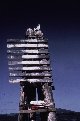 |
Microwave navigation instrument setup on dolphin. |
Alaska |
2283 |  |
Setting up microwave navigation instrument on lighthouse. Party off of PEIRCE |
Penobscot Bay, Maine 1985 |
2284 |  |
Microwave navigation instrument with attenuator for calibration. Party off of PEIRCE |
Penobscot Bay, Maine 1985 |
2285 |  |
Microwave navigation instrument setup on lighthouse in Delaware Bay. Party off of PEIRCE |
Delaware Bay 1985 |
2286 |  |
Looking up to microwave navigation instrument setup on Delaware Bay Lighthouse. Party off of PEIRCE |
Delaware Bay 1985 |
2287 |  |
Setting up microwave navigation instrument on pier at Fredericksted. Party off of PEIRCE |
Fredericksted, St. Croix, U.S. Virgin Islands 1985 |
2288 |  |
Mike Abbott and Skip Payne conducting range-azimuth work on "Guano Rock". Party off of FAIRWEATHER |
Alaska 1985 |
2289 |  |
Conducting range-azimuth hydrography from buoy in Indian River Inlet. Party off of PEIRCE |
Indian River Inlet, Alaska 1984 |
2290 |  |
Conducting range-azimuth hydrography at Pelican Cay. All of the elements of range-azimuth. Observer tracking boat with Wild T-2 theodolite. Party off of WHITING |
Pelican Cay, U.S. Virgin Islands 1975 |
2291 |  |
Conducting range-azimuth hydrography from southeast side of Hans Lollik Island. Party off of WHITING |
Hans Lollik Island, U.S. Virgin Islands 1975 |
2292 |  |
Conducting range-azimuth hydrography in Miami. Party off of WHITING |
Miami, Florida 1978 |
2293 |  |
Conducting range-azimuth hydrography on south coast of Hawaii. Party off of RAINIER |
South coast of big island of Hawaii 1980 |
2294 |  |
Microwave navigation instrument on east side of Penobscot Bay. Geodetic target and total station azimuth and distance instrument. Conducting geodetic operations to determine microwave navigation site. Party off of PEIRCE |
Penobscot Bay, Maine 1985 |
2295 |  |
Setup for calibrating microwave navigation instruments. Master unit set up across sound. Calibration crew from NOAA Ship WHITING |
Lovango Cay, Pillsbury Sound, U.S. Virgin Islands 1975 |
2296 |  |
View of microwave navigation instrument calibration setup. Master unit set up across sound. Calibration crew from NOAA Ship WHITING |
Lovango Cay, Pillsbury Sound, U.S. Virgin Islands 1975 |
2297 |  |
Launch readout of microwave navigation instrument distances in meters. The vessel is located the indicated distance in meters from stations #1 and #3. Readout on sounding boat from NOAA Ship PEIRCE |
Atlantic coast of United States 1985 |
2298 |  |
Diagram showing relationship of tide to marker at Poolbeg Lighthouse. Datum referred to low water April 8, 1837 for County Dublin. Note use of Mean Sea Level |
Poolbeg Lighthouse, Ireland 1837 |
2299 |  |
Tide gauge at Knik Harbor showing range of tide. Over 30 feet of tide. Party of Eoline Hand |
Vicinity of Anchorage, Alaska 1918 |

