


Caprock Canyons State Park and Trailway
P O Box 204
Quitaque TX 79255
806/455-1492

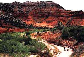
History: Caprock Canyons State Park, 100 miles southeast of Amarillo in Briscoe County, was opened in 1982. It consists of 15,313.6 acres (including the Trailway, a 64.25 mile Rail-to-Trail conversion, acquired by donation in 1992 from a Railroad entrepreneur). This acquisition added recreational adventure, stretching from the western terminus at South Plains up on top of the caprock escarpment to the eastern terminus of Estelline in the Red River Valley. This multi-use trail (hike, bike, and equestrian), opened in 1993, stretches the park through Floyd, Briscoe, and Hall counties crossing 46 bridges and running through Clarity tunnel, one of the last active railroad tunnel in Texas. The 64.25 miles of the Trailway are open to the public from Estelline to South Plains.

Caprock Canyons is home of the
official Texas State Bison Herd.
The escarpment's scenic canyons were home for Indians of several cultures, including the Folsom culture of more than 10,000 years ago. A decrease or disappearance of some species, from Folsom times to present, indicates a gradual drying and perhaps warming of the climate. Later paleolithic hunters, associated with the Plainview culture, also occupied the area from 8000-9,000 years ago. Only slight traces of these people have been found at Caprock Canyons. As the climate became increasingly drier, the period of hunting and gathering cultures began. Smaller animals, as well as plant materials, made up the diet of the people. The Archaic period lasted from 8,000 to 2,000 years ago. Artifacts from this period include boiling pebbles for heating food, grinding stones for processing seeds, oval knives, and corner-notched or indented dart points. The Neo-Indian state was characterized by the appearance of arrow points and pottery. During the latter part of this period, 800 years ago until the Spanish exploration, permanent settlements were established, and agriculture was being practiced to some extent. These people traded Alibates flint for pottery, turquoise, and obsidian from the Puebloan groups to the west.
The region's historic era began when Spanish explorer Coronado traveled across the plains in 1541. After Spanish colonies were established in New Mexico around 1600, two-way trade between Plains Indians and New Mexicans began and gradually increased. The Plains Apache, present when Coronado arrived, acquired horses and became proficient buffalo hunters. They were displaced by the Comanche, who arrived in the early 1700s and dominated northwestern Texas, until they were finally subdued in the 1870s. During the Comanche reign, trade prospered and New Mexican buffalo hunters, known as ciboleros, and traders, known as Comancheros, were frequent visitors to this area. Las Lenguas Creek, a few miles south of the park, was a major trade area, and a site excavated on Quitaque Creek has produced artifacts indicating that it may have been a cibolero camp.
After 1874, Anglo settlement began, counties were organized, and ranches were established. Famed cattleman Charles Goodnight moved cattle into Palo Duro Canyon in 1876. In 1882, he bought vast areas of land for John G. Adair, who became owner of the noted J. A. Ranch. The land on which the park is located was included in the purchase. A railroad was built into this area in 1887, and by 1890, the town of Quitaque, with a population of 30, was a regular stage stop. The use of suitable lands for farming increased as more settlers arrived in the early 1900s, but most of the broken country is still ranch land. After passing through the hands of several owners, most of the land that now lies within park boundaries was acquired in 1936 by Theo Geisler, who died on August 15, 1969. The state purchased the land in 1975, and the park's Lake Theo was named after Geisler.
Activities: The park offers day-use and camping facilities; hiking; horseback riding; mountain biking; boating on a no-wake lake (120-surface-acres, 30' when full); fishing; lake swimming; a scenic drive; guided tours; and seasonal concessions offering horse rentals. Almost 90 miles of multi-use trails range from the very difficult in rugged terrain to trails with less than 3% grade. About 25 miles of the trails include cliffs and drop-offs, with steep climbs and descents that are recommended only for the experienced equestrian and mountain bike riders. When visiting Caprock Canyons State Park, be sure to check out the recently completed audio driving guide to the park. It's like having a tour guide on your own schedule and it's free! The audio guide is available for check-out, at the park headquarters, on tape or CD ($5 deposit).
There are 13 trails in all, (some still under construction), including 6 along the Trailway, which are each approximately 10 miles long and provide parking lots at each trailhead.
Water is usually available for animals along the trails, and some potable water is available at selected sites; but is it highly recommended that personal water is carried for each adventurer. The development of the trails change on a daily basis.
Horse Rentals - Quitaque Riding Stables, 806/455-1208 - guided or unsupervised rentals available. Reservations should be made at least 1 day in advance. Group discount rates available. Link to more equestrian information.
- Check the Calendar for events and access restrictions scheduled within the next 3 months.
- More Information on outdoor activities from the Experience Texas page.
Area Attractions: Nearby points of interest are the Cities of Amarillo and Lubbock, the two major populations centers on the Southern High Plains, and each is about a two-hour drive from the park. The City of Canyon is 82 miles northwest and is the home of Panhandle-Plains Historical Museum, located on the campus of West Texas State University. The museum has numerous exhibits that pertain to both history and prehistory of this area. Palo Duro Canyon State Park is 93 miles to the northwest and is noted for its scenic beauty and the outdoor musical drama "TEXAS" which is performed each evening except Sunday from mid-June through late August. Lake Meredith, the largest impoundment in the Panhandle, is located on the Canadian River about 130 miles north of the park (Lake Meredith National Recreation Area), on the southeast side of this lake Alibates Flint Quarries National Monument, commemorates and protects the site of prehistoric flint quarries. Other lakes providing opportunities for fishing, boating, and water sports are Green Belt Dam Reservoir northwest of Clarendon, Mackenzie Reservoir in Tule Canyon 32 miles to the northwest and White River Lake 90 miles south of the park. For more information on the city of Quitaque go to the Quitaque Chamber of Commerce web site.
- Facilities and Fee Information
- Caprock Canyons Facility Map.
 (PDF 145.8 KB)
 - Caprock
Canyons Trailway Map and Guide. (PDF 137.7 KB)
Natural Features:
Flora: Vegetational
communities vary from the sparse badlands, with their juniper, mesquite,
and cacti, to
the abounding bottomlands
with tall grasses, cottonwoods, plum thickets, and hackberries.
Fauna: The park harbors numerous species of wildlife such as African aoudad sheep, mule and white-tailed Deer, raccoons, coyotes, bobcats, opossums, porcupines, foxes, and over 175 species of birds. The pride of Caprock Canyons is the official Texas State Bison Herd (the largest herd of buffalo in the state park system), and the not-often-seen Golden Eagles. There is good fishing in Lake Theo for bass and catfish.
More information on the wildlife mentioned here:
Topography: Topographic features reflecting the characteristics of exposed geological formations and erosional processes are the most outstanding attractions in the park.
Elevation: From the eastern to the western border of the park, elevation increases from 2180 to 3180 feet above mean sea level for a maximum relief of 1000 feet. Most of this area contains exposed, red sandstones and siltstones belonging to the Quartermaster formation of the Permian Age

Weather: Average minimum temperature in January is 19 degrees. The average maximum in July is 91 degrees. Average rainfall is 20.4 inches.
Schedule: There is an honor box at headquarters used to collect camping and day-use fees when the office is closed. Gate Hours: Friday - Saturday 8 a.m. - 6 p.m., Sunday - Thursday 8 a.m. - noon, 1 p.m. to 5 p.m. For more details, call the park.Check the Calendar for events and access restrictions scheduled within the next 3 months.
Directions: The park is 3.5 miles north of State Highway 86 in Quitaque on FM 1065.
Current conditions including, fire bans & water levels, can vary from day to day. For more details, contact the park.


 Texas Parks and Wildlife Department, 4200 Smith School Road, Austin, TX 78744