
- Home
- About S&T
- Taxa/Organisms
- Ecosystems
- Issues
- Methods & Tools
- Reports & Publications
- Location
- Search
2007 | Publisher: Other (Blackewll Publishing Company) | Format: URL
biology.usgs.gov — This resource is a glossary of terms that assist in the interpretation and understanding of genetics resources found on the Genetics and Genomics website of the United States Geological Survey (USGS). The following glossary was made available to the Genetics and Genomics project website, with special permission obtained from the following More...

2007 | Publisher: NBII | Format: URL
www.nbii.gov — This site is a primary and supplemental resource focused on non-human aspects of genetic biodiversity. The scope of the National Biological Information Infrastructure is on non-human biological and natural resources. Users can link to the following topics: Genetic Diversity, Agriculture & Genetic Diversity, Basic Genetics
2001 | Publisher: USGS (Earth Surface Processes Team - Central Region) | Science Center: USGS Other | Format: .PDF
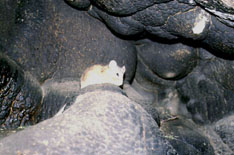
esp.cr.usgs.gov — This web resource links to the database and pdf version of the USGS/NOAA North American Packrat Midden Database Data Dictionary. The North American Packrat Midden Database is a joint project developed by the U.S. Geological Survey and the National Oceanic and Atmospheric Administration, with the purpose to provide researchers with access to More...
Publisher: USGS | Science Center: Southwest Biological Science Center (SBSC, Flagstaff) | Format: URL
sbsc.wr.usgs.gov — The purpose of this research project is to document vegetation change in the arid lands of the southwestern United States. The project compiles data on past and present plant distributions. These plant distributions are combined with data on past, present, and future climates to predict future plant distributions. The project requires four major More...

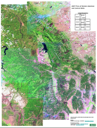
Publisher: USGS | Science Center: Northern Rocky Mountain Science Center (NRMSC, Bozeman) | Format: URL
nrmsc.usgs.gov — This site reflects satellite image mosaics of recent fire years from western Montana and central Idaho. Mosaic PDF versions of maps from 2000, 2003, and 2007 are available, and are intended to assist by providing the location of notable burns for the more significant fire years in western Montana and central Idaho. The aim is also to provide a More...
Publisher: USGS | Science Center: Southwest Biological Science Center (SBSC, Flagstaff) | Format: URL
sbsc.wr.usgs.gov — The Internet Map Server (IMS) visually displays the non-native, invasive plants (weed) occurrences in the current (2003) SWEMP database. An IMS allows you to interactively draw, query, and print maps. The SWEMP IMS was developed from ESRI's ArcIMS presentation product.The Southwest Exotic Plant Information Clearinghouse is a cooperative effort More...
Publisher: USGS | Science Center: Florida Integrated Science Center (FISC, Gainesville) | Format: URL
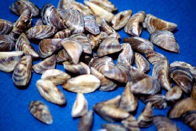
fl.biology.usgs.gov — This website is a map that shows the Progression of the Zebra Mussel (Dreissena polymorpha) Distribution in North America. The site links to a distribution map in small lakes and also a photo gallery.
Publisher: USGS | Science Center: Alaska Science Center (ASC, Anchorage) | Format: URL
www.absc.usgs.gov — This site links to a database of bird distribution which looks at patterns in the numbers of birds detected among Alaska Off-road Breeding Bird Survey routes. The database can be searched in two different ways: by area, and by species. To find out more about the data contained in the database of bird distribution, take a look at the metadata page, More...
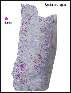
Publisher: USGS | Science Center: Forest and Rangeland Ecosystem Science Center (FRESC, Corvallis) | Format: URL
fresc.usgs.gov — This dataset is an ArcInfo point coverage depicting obstacles to anadromous fish migration in western Oregon. Data were compiled by fourth-field hydrologic unit code (HUC) from the Oregon Department of Fish and Wildlife StreamNet Database and from reports by fisheries biologists in various management agencies. Both natural and constructed (e.g., More...
Publisher: USGS | Format: URL
pubs.usgs.gov — This web resource describes the U.S. Geological Survey (USGS) Across Trophic Level System Simulation (ATLSS) Program, which has produced a set of models, including spatially explicit species index models, population demography models, and ecosystem process models that are designed to evaluate the ecological effects of hydrologic scenarios on More...
Publisher: USGS | Science Center: National Wetlands Research Center (NWRC, Lafayette) | Format: URL
www.nwrc.usgs.gov — The National Wetlands Research Center provides a list of links to searchable databases and electronic resources related to Wetlands research at numerous government agencies such as EPA, DTIC, Energy, Forest Service. Links include access to data and information on the nation's biological resources: APIRS Online, the database of aquatic, wetland More...
Publisher: Other Federal Agency (Center for Coastal Monitoring and Assessment (CCMA)) | Format: URL
www8.nos.noaa.gov — This website identifies and assesses biological effects associated with contaminant exposure. Over forty intensive regional studies have been conducted since 1986 using the Sediment Quality Triad approach which utilizes a stratified random sampling method to determine the areal extent of contaminated sediments. The data include: sediment More...
