- Home
- About S&T
- Taxa/Organisms
- Ecosystems
- Issues
- Methods & Tools
- Reports & Publications
- Location
- Search
Publisher: USGS | Science Center: Fort Collins Science Center (FORT, Ft. Collins) | Format: URL
www.fort.usgs.gov — This web resource is a compilation of research projects related to Energy, Land Use, and Sagebrush Ecosystems. Investigators at the USGS Science Centers (FORT and FRESC), and Central Regional Office have brought biological and ecosystem research and mapping expertise to a partnership with the Bureau of Land Management, Wyoming Game and Fish More...
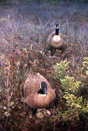
March 22 2001 | Publisher: USGS | Science Center: Alaska Science Center (ASC, Anchorage) | Format: URL
www.absc.usgs.gov — This study was designed to measure the effects of surgically-implanted radios on geese. Biologists are also gathering data on movements of geese within the Anchorage Bowl. That information may help local wildlife managers assess how often birds move into areas where they are in conflict with humans.
Publisher: USGS | Format: URL
pubs.usgs.gov — This web resource describes the U.S. Geological Survey (USGS) Across Trophic Level System Simulation (ATLSS) Program, which has produced a set of models, including spatially explicit species index models, population demography models, and ecosystem process models that are designed to evaluate the ecological effects of hydrologic scenarios on More...
Publisher: USGS (Coastal and Marine Geology Program) | Format: URL
terraweb.wr.usgs.gov — This website is the Terrestrial Remote Sensing Software and Research Web Server. Featured on this site are image products and information generated using remote sensing in various Earth environments. Digital satellite, sonar, bathymetry, elevation, aerial, and ground photography image products for practical applications, such as resource More...

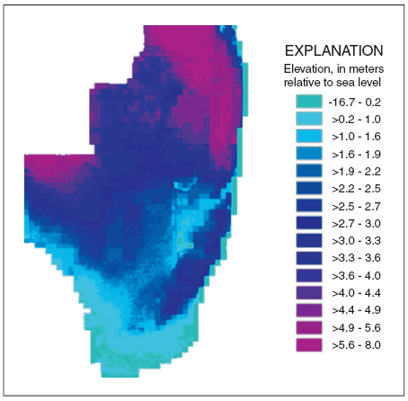
Publisher: USGS | Format: URL
pubs.usgs.gov — This web resource is a map that shows all of the biological communities and geomorphology of patch reefs in Biscayne National Park, Florida. The map shows all of the patch reefs in Biscayne National Park that were surveyed in September 2003. Scientists investigated the relationships among physical, benthic, and fish variables in effort to help More...

Publisher: USGS | Science Center: Alaska Science Center (ASC, Anchorage) | Format: URL
www.absc.usgs.gov — This site links to a database of bird distribution which looks at patterns in the numbers of birds detected among Alaska Off-road Breeding Bird Survey routes. The database can be searched in two different ways: by area, and by species. To find out more about the data contained in the database of bird distribution, take a look at the metadata page, More...

Publisher: USGS | Science Center: Northern Rocky Mountain Science Center (NRMSC, Bozeman) | Format: URL
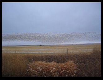
nrmsc.usgs.gov — Identification of Bird Migration Events in NEXRAD Data is especially important to the management of shorebirds, waterfowl, and other wetland birds. Such historic information can be used for habitat acquisition programs, design of agricultural conservation programs, evaluating energy development projects, and designing inventory and monitoring More...
Publisher: USGS | Science Center: Fort Collins Science Center (FORT, Ft. Collins) | Format: URL
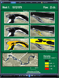
www.fort.usgs.gov — Smart River GIS allows simultaneous views of river hydraulics, species specific habitat, and fish population simulations, for a better understanding of complex ecological interactions. Scientists used existing data sets from the South Platte River in Colorado to develop a prototype, with multiple layers of geographic information system, GIS, More...
Publisher: USGS | Science Center: Alaska Science Center (ASC, Anchorage) | Format: URL
alaska.usgs.gov — Space-borne synthetic aperture radar (SAR) imaging has proved to be a valuable research tool in polar regions because of its ability to penetrate cloud cover, acquire imagery during the day or night, and acquire imagery at a high temporal resolution. SAR imagery has been used extensively to monitor sea ice, lake ice, glaciers, snow cover, and More...
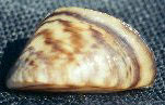
Publisher: USGS | Science Center: Florida Integrated Science Center (FISC, Gainesville) | Format: URL
fl.biology.usgs.gov — This web resource is a map representation of the distribution of zebra and quagga mussels in U.S. lakes. Zebra mussels were first detected in 1988 in Lake St. Clair, located between Lake Huron and Lake Erie. Within just a few years, they spread into all five of the Great Lakes. Since then, zebra mussels have spread into many large navigable More...