AZ
SKYWARNTM STORM SPOTTER PROGRAM
( PHOTOS
/ CRITERIA
/ SKYWARNTM
TRAINING )
When significant, or severe weather occurs anywhere within
the Phoenix County Warning Area, the Weather Service turns to the SkywarnTM
Spotter Network to obtain timely and accurate reports. This network is
comprised of individuals or groups, generally associated with the following:
1) Emergency Service Organizations (Fire, Police, etc), 2) Volunteer Organizations
(HAM Radio, Citizens' Band Radio, etc), 3) Individual Citizens, 4) Cooperative
Observers.
Be sure to check out the
National SkywarnTM Homepage
to get the national perspective.
The Arizona SkywarnTM Net (ASN) welcomes
trained spotters to check into our weekly nets
on these repeaters:
Storm spotters are specially trained
by NWS personnel to be able to recognize and report
severe and unusual weather occurrences. When this
occurs, they phone their reports into the NWS
office having warning responsibility for their
county. Spotters in Southern Gila, La Paz, Maricopa,
Northwest Pinal, Yuma, Imperial CA and Eastern
Riverside CA counties should contact the Phoenix
forecast office. Spotters in Apache, Coconino,
Navajo, Northern Gila and Yavapai counties should
call the Flagstaff office. Spotters located in
Southeast Pinal, Pima, Santa Cruz, Cochise, Graham
and Greenlee counties should contact the Tucson
office. Finally, spotters in Mohave county should
call the Las Vegas Weather Service Office.
Spotters should tell personnel at
the responsible office briefly WHAT
they saw or are seeing, WHERE
they are or where they were when it was going
on, WHEN it was occurring
and WHAT is/was it
doing. They should also include their name, location
and their assigned spotter ID number.
SEVERE
WEATHER SPOTTING - DESERT SOUTHWEST STYLE
The following are examples of weather
phenomena that commonly lead to or depict severe
weather. In most cases, what is seen below occurs
during the Monsoon, or the summer thunderstorm
season which typically runs from July 4 through
September 15.
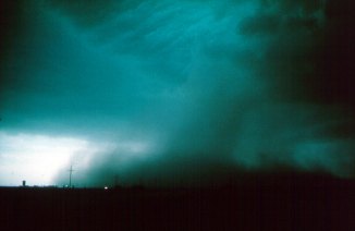 |
Downburst
Hazards. Downburst
winds can exceed 100 mph and are capable of
doing the same damage as a weak to strong
tornado. Rapidly shifting wind direction and
changes in visibility pose problems to mobile
spotters. (Photo by Alan Moller) |
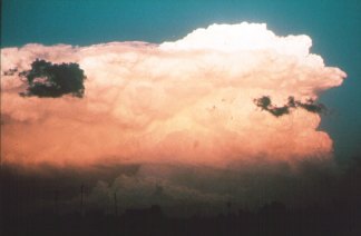 |
Overshooting
Top. An overshooting
top, an indicator of a potential severe thunderstorm,
is evident as the "bubble" of cloud
material rising above the rest of the storm.
The area underneath the overshooting top is
the area of strongest updraft, and is the
preferred area for severe weather formation.
(Photo courtesy of Bill Martin) |
|
|
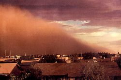
Haboob.
A haboob is a violent dust or sandstorm
occurring on the southwest deserts of Arizona.
It depicts the leading edge, or gust front,
of an approaching storm, and wind speeds
can exceed 60 mph!
|
Although tornadoes are rare during the Monsoon,
they can and do occur. There is a misconception
that highway underpasses are a safe shelter for
those caught in the path of a tornado. This is
not the case! The following presentation "Highway
Underpasses as Tornado Shelters"
explains why this is so - this is an excellent
presentation. Check it out!
CRITERIA
The following criteria are what
spotters should look for when phoning in their
reports. They should always call the responsible
Weather Service Office when any of the below are
noted:
-
TORNADO
(on the ground) or FUNNEL CLOUD
(tail not touching the ground)
-
ROTATING WALL CLOUD
-
WIND (estimated or measured
at 40 mph or more)
-
MICROBURST
(visually identified)
-
RAINFALL (1/2
inch (.50) or more in 30 minutes)
-
FLOODING
(of any kind)
-
DAMAGE
and/or DEATHS
and/or INJURIES
due to the weather event
-
HAIL (1/2 inch (.50) diameter, or greater)
-
VISIBILITY (less than 1/4
mile due to fog, dust, blowing snow or ash)
-
SNOWFALL (accumulating at
a rate of 1 inch or more per hour.
SPOTTERS SHOULD
NOT CALL NWS PERSONNEL WITH ROUTINE WEATHER OR
FOR FORECASTS!!
TRAINING
Please visit our Weather Spotter Training Page
for scheduled classes.
Adult SKYWARNTM volunteers are community
spirited individuals, who understand that they
play an essential role in providing storm information
to the National Weather Service. Spotters are
also hikers, sports and outdoor enthusiasts, and
those who routinely work outdoors. Many volunteer
spotters are amateur radio operators and participate
in a special amateur radio network during severe
weather.
If you have any questions, please
contact either Steve Sipple or Ken Waters at 602.275.0073
at the NWS Phoenix Forecast Office. Please call
during business hours only - 7 am to 330 pm M-F.
They will be happy to answer them for you!
** We especially need
new spotters in the remote areas of our County
Warning Area (CWA), which includes Maricopa, northwest
Pinal, and southern Gila counties!
|