|
|
 |
Rain, Drought, Urbanization Contributing Factors for Storms
|
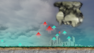
On March 14, 2008, a tornado swept through downtown Atlanta, its 130 mile-per-hour winds ripping holes in the roof of the Georgia Dome, blowing out office windows and trashing parts of Centennial Olympic Park. It was an event so rare in an urban landscape that researchers immediately began to examine NASA satellite data and historical archives to see what weather and climatological ingredients may have combined to brew such a storm. Read more at http://www.nasa.gov/topics/earth/features/atlanta_tornado.html.
|
|

|
|
The animation shows how, in the days leading up to March 14, 2008, pockets of rain fell between drought-ravaged areas that saw no rain, setting up boundaries of dry and moist air. These boundaries along with urban-rural land cover boundaries produce circulations and rising air similar to a sea breeze. They may also serve as localized regions of enhancement for existing storms or initiation of new storms. Modeling studies suggest that these boundaries may have been a factor in the storms that produced the Atlanta tornado.
Duration: 1.5 minutes
Available formats:
1280x720 (30 fps)
Frames
1280x720 (30 fps)
MPEG-4
14 MB
1280x720 (30 fps)
MPEG-2
77 MB
512x288 (30 fps)
MPEG-1
18 MB
1280x720
TIFF
2 MB
320x180
PNG
255 KB
160x80
PNG
63 KB
80x40
PNG
16 KB
How to play our movies
|
|
|
Back to Top
|
|
|
|

