|
|
|
|
Data and Tools
|
|
|
|
|
|
What's New
|
|

 |
Unidata is pleased to announce that we are now able to relay COAMPS and NOGAPS model data in the LDM/IDD under the FNMOC feedtype.
The streams are products of Fleet Numerical Meteorology and Oceanography Center (or FNMOC), and have been available as point-to-point IDD feeds since 2000 under the names FNMOC or COAMPS or NOGAPS.
Posted: May 6, 2009 |
|
|
|
|

Farewell to a dear friend
 It is with the deepest sadness that we let our community know that Prof. Elen Maria Camara Cutrim died on 15 April, peacefully and surrounded by her family and friends.
Prof. Cutrim taught in the Department of Geography at Western Michigan University in Kalamazoo, Michigan. She was a long time member of the Unidata community as well as an active participant in our Users Committee since 2003.
In losing Elen we have lost not only a dear friend but an inspiration. She will be remembered for her collegiality, cheerful demeanor, and always-positive outlook. Elen made significant contributions to furthering Unidata's goals by helping to broaden the user base to other disciplines and countries by being a strong promoter of Unidata technologies and a truly outstanding ambassador for Unidata in national and international venues. For her efforts that reflect the goals and ideals of the Unidata program, Elen received the 2009 Russell L. DeSouza Award.
Although she will be dearly missed, her positive influence on all of us and the Unidata program will persist for years to come. We will continue to carryout our work with the same enthusiasm, energy, and openness that Elen exhibited throughout her life.
Memorial contributions may be made to: Department of Geography, College of Arts and Sciences, Western Michigan University, 3219 Wood Hall, Kalamazoo, Michigan 49008. Make checks payable to Western Michigan University with Elen Cutrim Memorial Fund on the the memo line.
Posted: May 1, 2009 |
|

|
Unidata's triennial users workshop is scheduled this year for 8-12 June 2009 in Boulder. The theme is Using Operational and Experimental Observations in Geoscience Education. Six focus areas have been identified: Remote Sensing, Data Assimilation, Instrumentation, Climate Observations, Field Experiments, and Research and Operational Networks.The workshop will feature a mix of hands-on labs with informative presentations as well as a few social events designed to allow participants to converse and get to know one another. For more information see Workshop Homepage.
New this year, a poster session!
Posted: March 31, 2009 |
|
 Unidata unveils its 25-year anniversary logo Unidata unveils its 25-year anniversary logo
Unidata unveils its 25-year anniversary logo as the program celebrates this significant milestone with a series of planned events throughout the year.
In 1983, a group of atmospheric scientists met in Madison, Wisconsin to
develop a plan that became the basis for the Unidata program. That plan
became a proposal that was funded by the National Science Foundation in
1984. In the fall of that year, UCAR established the Unidata Project
Office and appointed David Fulker as its first director.
While Unidata's roots originated in a modest project that was designed,
among other things, to provide real-time weather data to synoptic
meteorologists in U.S. universities, its mission and vision have evolved,
and our community has grown since then.
We are proud of the work we do here at Unidata, and we acknowledge with
gratitude our partners throughout the community.
|
|
 The Unidata Training Workshop The Unidata Training Workshop
The Unidata Software Training Workshop sessions for 2009 will be from July 29 - August 15. The costs to participants are for travel, food, and lodging in addition to a $50 dollar registration fee for each individual session. For more details see the announcement.
|
|
|
|
|
|
|
|
|
|
|
|
|
|
|
|
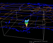
IDV display of wind iso-surface of 27 m/s derived from a WS-ETA (4 KM resolution) model output during Katrina's landfall, and including Level II RADAR BREF 14 data from KLIX and KMOB.
|
|
|
|
|
|
|
|
The College of DuPage Next Generation Weather Lab utilizes the LDM/IDD, GEMPAK and McIDAS to provide timely and useful graphical and
textual weather data. more >>
|
|
|