- Home
- About S&T
- Taxa/Organisms
- Ecosystems
- Issues
- Methods & Tools
- Reports & Publications
- Location
- Search
May 21 2009 | Publisher: USGS | Format: URL
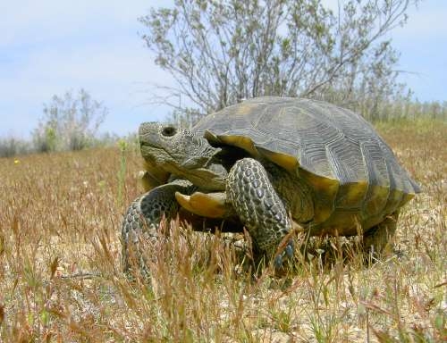
pubs.usgs.gov — A new tool provides land managers with a predictive model for mapping the potential distribution of desert tortoise habitat and to evaluate different land-use issues the tortoises face at a landscape scale. The model incorporates an extensive amount of field data for desert tortoises, as well as environmental data related to landscape attributes, More...
May 2009 | Publisher: USGS | Science Center: Western Ecological Research Center (WERC, Sacramento) | Format: URL
www.werc.usgs.gov — This study encompasses the range of the Mojave population of desert tortoises north and west of the Colorado River, as well as a small portion of the northwest Sonoran Desert, and comprises 336,594 square kilometers of basin-and-range topography, including parts of California, Nevada, Utah, and Arizona. The habitat model provides a basal More...

June 2001 | Publisher: USGS | Science Center: Western Ecological Research Center (WERC, Sacramento) | Format: URL
www.werc.usgs.gov — Salvage of injured, recently dead, ill, and dying desert tortoises is a very important part of recovery programs for these reptiles. Salvaged desert tortoises can provide a wealth of information about such subjects as health, disease, presence of heavy metals and other toxicants, and causes of mortality in populations. When tortoises are salvaged More...

Publisher: USGS | Science Center: Western Ecological Research Center (WERC, Sacramento) | Format: .PDF
www.werc.usgs.gov — One cause for declines in desert tortoise populations is predation on juveniles by common ravens (Corvus corax), a predatory bird species native to the Mojave Desert. The Recovery Plan for the Desert Tortoise recommended that research be conducted on sources of mortality (including natural predation). This study was implemented to investigate the More...
Publisher: USGS | Science Center: Western Ecological Research Center (WERC, Sacramento) | Format: URL
www.werc.usgs.gov — This project started to conduct an extensive review of the literature pertaining to restoring degraded desert tortoise habitat, with emphasis on the Mojave Desert. Recovery to pre-disturbance plant cover and biomass may take from 50-300 years while complete ecosystem recovery may require over 3,000 years. Restoration can be used to enhance the More...
Publisher: USGS | Science Center: Southwest Biological Science Center (SBSC, Flagstaff) | Format: URL
sbsc.wr.usgs.gov — The desert tortoise is listed as a threatened species under federal and California versions of the Endangered Species Act. The recovery plan for the desert tortoise recommended that additional data be collected on the reproductive ecology of the species throughout the range. Annual meetings between USGS, Biological Resources Division researchers More...

Publisher: USGS | Science Center: Southwest Biological Science Center (SBSC, Flagstaff) | Format: URL
sbsc.wr.usgs.gov — The Internet Map Server (IMS) visually displays the non-native, invasive plants (weed) occurrences in the current (2003) SWEMP database. An IMS allows you to interactively draw, query, and print maps. The SWEMP IMS was developed from ESRI's ArcIMS presentation product.The Southwest Exotic Plant Information Clearinghouse is a cooperative effort More...

Publisher: USGS | Science Center: Southwest Biological Science Center (SBSC, Flagstaff) | Format: URL
sbsc.wr.usgs.gov — The purpose of this research project is to document vegetation change in the arid lands of the southwestern United States. The project compiles data on past and present plant distributions. These plant distributions are combined with data on past, present, and future climates to predict future plant distributions. The project requires four major More...

Publisher: Other Federal Agency (United States Forest Service (USFS)) | Format: .PDF
www.fs.fed.us — USGS scientist Jon Keeley led a team of scientists from various agencies and academic institutions in developing a framework that will inform fire management of ecosystems. This review uses a scientific synthesis to provide an ecological foundation for management of diverse ecosystems. Ecosystem-based management requires different strategies on More...

Publisher: USGS | Science Center: Biological Informatics | Format: URL
biology.usgs.gov — This web page presents samples of genetics and genomics research from the USGS Biological Resources Discipline about the conservation genetics of landscapes.

Publisher: USGS | Format: URL
3dparks.wr.usgs.gov — This web resource is a collection of anaglyphic images (3D) of the Powell Survey of Colorado River Canyon Country. All images on this website are derived from photography that Major John Wesley Powell commissioned to document his Second Expedition (1871-1872) and later expeditions on the Colorado Plateau. This website contains a collection of 3D More...

Publisher: USGS | Format: URL
biology.usgs.gov — This website addresses some of these questions for several regions of North America, conveying the importance of a historical context for understanding ongoing changes in land cover and land use. It also aims to inspire scientists, educators, and science administrators to contribute to the development of a comprehensive land-use history of North More...