
- Home
- About S&T
- Taxa/Organisms
- Ecosystems
- Issues
- Methods & Tools
- Reports & Publications
- Location
- Search
Publisher: USGS | Science Center: Fort Collins Science Center (FORT, Ft. Collins) | Format: URL
www.fort.usgs.gov — This web resource is a compilation of research projects related to Energy, Land Use, and Sagebrush Ecosystems. Investigators at the USGS Science Centers (FORT and FRESC), and Central Regional Office have brought biological and ecosystem research and mapping expertise to a partnership with the Bureau of Land Management, Wyoming Game and Fish More...

Publisher: USGS | Science Center: Southwest Biological Science Center (SBSC, Flagstaff) | Format: URL
sbsc.wr.usgs.gov — The purpose of this research project is to document vegetation change in the arid lands of the southwestern United States. The project compiles data on past and present plant distributions. These plant distributions are combined with data on past, present, and future climates to predict future plant distributions. The project requires four major More...

Publisher: USGS | Format: URL
pubs.usgs.gov — This web resource describes the U.S. Geological Survey (USGS) Across Trophic Level System Simulation (ATLSS) Program, which has produced a set of models, including spatially explicit species index models, population demography models, and ecosystem process models that are designed to evaluate the ecological effects of hydrologic scenarios on More...

Publisher: USGS | Format: URL
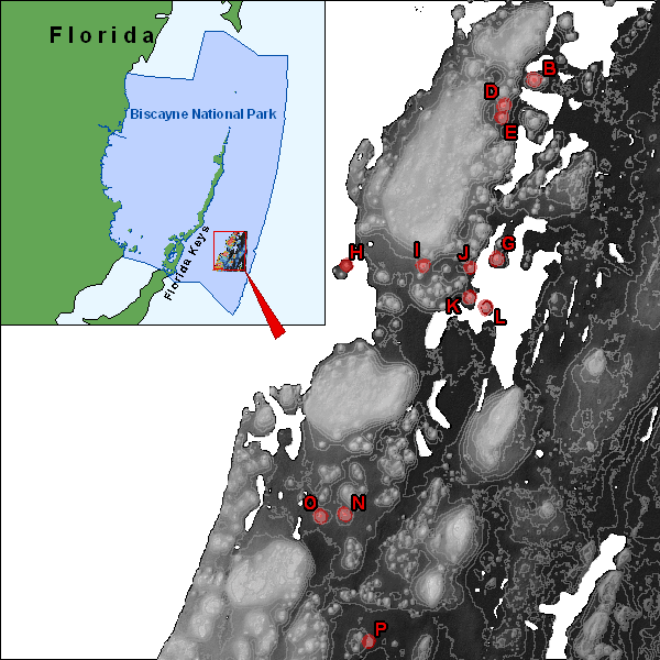
pubs.usgs.gov — This web resource is a map that shows all of the biological communities and geomorphology of patch reefs in Biscayne National Park, Florida. The map shows all of the patch reefs in Biscayne National Park that were surveyed in September 2003. Scientists investigated the relationships among physical, benthic, and fish variables in effort to help More...
Publisher: USGS | Science Center: Southwest Biological Science Center (SBSC, Flagstaff) | Format: URL
sbsc.wr.usgs.gov — The Internet Map Server (IMS) visually displays the non-native, invasive plants (weed) occurrences in the current (2003) SWEMP database. An IMS allows you to interactively draw, query, and print maps. The SWEMP IMS was developed from ESRI's ArcIMS presentation product.The Southwest Exotic Plant Information Clearinghouse is a cooperative effort More...
Publisher: USGS | Science Center: Fort Collins Science Center (FORT, Ft. Collins) | Format: URL
www.fort.usgs.gov — Smart River GIS allows simultaneous views of river hydraulics, species specific habitat, and fish population simulations, for a better understanding of complex ecological interactions. Scientists used existing data sets from the South Platte River in Colorado to develop a prototype, with multiple layers of geographic information system, GIS, More...

