
 Feeds & Data
Magnitude 6.9 - GULF OF CALIFORNIA
2009 August 03 17:59:56 UTC
Earthquake Details
| Magnitude | 6.9 |
|---|---|
| Date-Time |
|
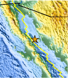
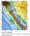
| Location | 29.066°N, 112.871°W |
| Depth | 10 km (6.2 miles) set by location program |
| Region | GULF OF CALIFORNIA |
| Distances |
|
| Location Uncertainty | horizontal +/- 7.1 km (4.4 miles); depth fixed by location program |
| Parameters | NST=140, Nph=140, Dmin=411.8 km, Rmss=1.31 sec, Gp= 97°, M-type=teleseismic moment magnitude (Mw), Version=7 |
| Source |
|
| Event ID | us2009jwbh |
- This event has been reviewed by a seismologist.
- Did you feel it? Report shaking and damage at your location. You can also view a map displaying accumulated data from your report and others.
Earthquake Summary

Tectonic Summary
Versión en Español
The Gulf of California earthquakes of August 3, 2009, occurred in the plate boundary region between the North America and Pacific plate. At the latitude of the earthquake, the Pacific plate moves northwest with respect to the North America plate at about 45 mm/y. The plate boundary beneath the Gulf consists of a series of transform faults separated by small spreading centers or pull-apart basins: earthquakes occur as the result of strike-slip faulting and normal faulting. The seismographically recorded radiation pattern of the main shock of August 3, 18:00 UTC, implies that the shock occurred as the result of strike-slip faulting, but the earthquake has not yet been associated with a specific geologically mapped fault. The largest historically recorded shocks from the Gulf of California have had magnitudes of about 7.
Earthquake Maps


Scientific & Technical Information

- Preliminary Earthquake Report
- U.S. Geological Survey, National Earthquake Information Center:
World Data Center for Seismology, Denver
