Follow this link to skip to the main content
NASA logo and link JPL logo
JPL Home EARTH Stars and Galaxies Science and Technology
Caltech Logo
Email News RSS Podcast Video
Mission to Mars' north poloar region Phoenix Mars Lander
› View Images Archives | › View 3D Images | › Raw images
       
  imageALT   
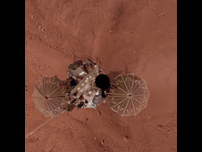
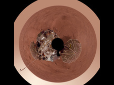
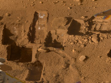
Composite View from Phoenix Lander
This mosaic of images from the Surface Stereo Imager camera on NASA's Phoenix Mars Lander shows several trenches dug by Phoenix, plus a corner of the spacecraft's deck and the Martian arctic plain stretching to the horizon.
› Read More July 2, 2009
       
       
  imageALT   
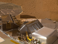
Phoenix Deck after Sample Deliveries
This mosaic of images from the Surface Stereo Imager camera on NASA's Phoenix Mars Lander shows a portion of the spacecraft's deck after deliveries of several Martian soil samples to instruments on the deck.
› Read More July 2, 2009
       
       
  imageALT   
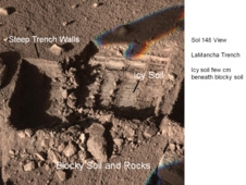
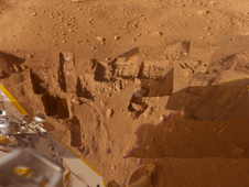
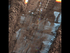
Composite View of Phoenix Trenches
Several of the trenches dug by NASA's Phoenix Mars Lander are displayed in this approximately true color mosaic of images from the lander's Surface Stereo Imager camera.
› Read More July 2, 2009
       
       
  imageALT   Dark Skies and Clouds Move in at Phoenix site
Clouds of dust and ice swirl past the Surface Stereo Imager (SSI) camera on NASA's Phoenix Mars Lander in a series of images taken on the 132nd Martian day of the mission (Oct. 7, 2008).
› Read More December 15, 2008
       
       
  imageALT   
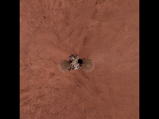
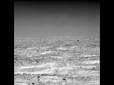
Martian Plain in Late Summer
The Surface Stereo Imager on NASA's Mars Phoenix Lander acquired this view of the textured plain near the lander at about 11 a.m. local Mars solar time during the mission's 124th Martian day, or sol (Sept. 29, 2008).
› Read More December 15, 2008
       
       
  imageALT   Phoenix Lander Self Portrait on Mars, Vertical Projection
This view is a vertical projection that combines hundreds of exposures taken by the Surface Stereo Imager camera on NASA's Mars Phoenix Lander and projects them as if looking down from above.
› Read More December 15, 2008
       
       
  imageALT   Phoenix Lander on Mars with Surrounding Terrain, Vertical Projection
This view is a vertical projection that combines more than 500 exposures taken by the Surface Stereo Imager camera on NASA's Mars Phoenix Lander and projects them as if looking down from above.
› Read More December 15, 2008
       
       
  imageALT   Geomorphic Map of Region Around Phoenix Mars Lander
This map shows shows a color-coded interpretation of geomorphic units -- categories based on surface textures and contours -- in the region where NASA's Phoenix Mars Lander has studied an arctic Martian plain.
› Read More December 15, 2008
       
       
  imageALT   Contour Map of Mars' Surface Beside Phoenix
the contours of polygons and relationship of polygon boundaries to trenches and other features in the workspace of the lander's Robotic Arm.
› Read More December 15, 2008
       
       
  imageALT   'La Mancha' Trench Dug by Phoenix Mars Lander
The Surface Stereo Imager camera on NASA's Phoenix Mars Lander captured this view on the mission's 148th Martian day, or sol (Oct. 24, 2008), about a week before the lander's final communication.
› Read More December 15, 2008
       
       
  imageALT   One Last Look at the Martian Arctic
This is a false color image of the Martian terrain and rock called "Winkies" (rock "Quadlings" in foreground) taken by the Surface Stereo Imager camera on NASA's Phoenix Mars Lander on Sol 151 of the mission (Oct. 27, 2008).
› Read More December 15, 2008
       
       
  imageALT   
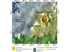
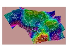
Contour Map of Mars' Surface Beside Phoenix, No Labels
This color-coded elevation map of the local terrain on the north side of NASA's Phoenix Mars Lander shows the contours of polygons and relationship of polygon boundaries to trenches and other features in the workspace of the lander's Robotic Arm.
› Read More December 15, 2008
       
       
  imageALT   'La Mancha' Trench Dug by Phoenix Mars Lander, No Labels
The Surface Stereo Imager camera on NASA's Phoenix Mars Lander captured this view on the mission's 148th Martian day, or sol (Oct. 24, 2008), about a week before the lander's final communication.
› Read More December 15, 2008
       
       
  imageALT   
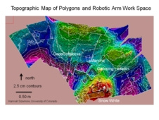
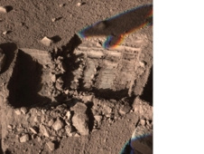
Frost Accumulates on 'Snow White' Trench
The Surface Stereo Imager (SSI) on NASA's Phoenix Mars Lander took this shadow-enhanced false color image of the "Snow White" trench, on the eastern end of Phoenix's digging area. The image was taken on Sol 144, or the 144th day of the mission, Oct. 20, 2008.
› Read More December 15, 2008
       
       
  imageALT   
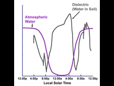
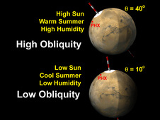
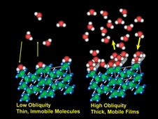
Adsorbed Water Illustration
The Thermal and Electrical Conductivity Probe on NASA's Phoenix Mars Lander detected small and variable amounts of water in the Martian soil.
› Read More December 15, 2008
       
       
  imageALT   Overnight Changes Recorded by Phoenix Conductivity Probe
This graph presents simplified data from overnight measurements by the Thermal and Electrical Conductivity Probe on NASA's Phoenix Mars Lander from noon of the mission's 70th Martian day, or sol, to noon the following sol (Aug. 5 to Aug. 6, 2008).
› Read More December 15, 2008
       
       
  imageALT   
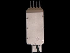
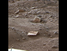
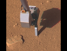
Conductivity Probe Inserted in Martian Soil, Sol 46
This image taken by the Surface Stereo Imager on NASA's Phoenix Mars Lander shows the lander's Thermal and Electrical Conductivity Probe (TECP), at the end of the Robotic Arm, on the 46th Martian day, or sol, of the mission (July 11, 2008).
› Read More December 15, 2008
       
       
  imageALT   Phoenix Lander's Thermal and Electrical Conductivity Probe
The Thermal and Electrical Conductivity Probe (TECP) for NASA's Phoenix Mars Lander took measurements in Martian soil and in the air.
› Read More December 15, 2008
       
       
  imageALT   Phoenix Lander on Mars with Surrounding Terrain, Polar Projection
This view is a polar projection that combines more than 500 exposures taken by the Surface Stereo Imager camera on NASA's Mars Phoenix Lander and projects them as if looking down from above.
› Read More December 15, 2008
       
       
  imageALT   Illustration of Mars' Obliquity Variation
The tilt of Mars' spin axis (obliquity) varies cyclically over hundreds of thousands of years, and affects the sunlight falling on the poles.
› Read More December 15, 2008
       
› View Images Archives


Related Links
› NASA Phoenix site

› University of Arizona Phoenix site

› JPL on Facebook and Twitter

› Landing Press Kit (3Mb - PDF)

› Launch Press Kit (6.5Mb - PDF)

› Mission Fact Sheet (244Kb - PDF)

› NASA Mars Exploration site

› NASA/JPL Landing Blog

Other Missions at Mars
› Mars Exploration Rovers

› JPL's Rover News and Image

› Mars Reconnaissance Orbiter

› Mars Odyssey

› Mars Express

 
   usa gov PRIVACY     |    FAQ     |     FEEDBACK Site Manager: Susan Watanabe
Webmasters: Tony Greicius, Martin Perez