Determining the Risk
To identify a community’s flood risk, FEMA conducts a Flood Insurance Study. The study includes statistical data for river flow, storm tides, hydrologic/hydraulic analyses, and rainfall and topographic surveys. FEMA uses this data to create the flood hazard maps that outline your community’s different flood risk areas.
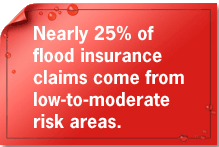
Floodplains and areas subject to coastal storm surge are shown as high-risk areas or Special Flood Hazard Areas (SFHAs). Some parts of floodplains may experience frequent flooding while others are only affected by severe storms. However, areas directly outside of these high-risk areas may also find themselves at considerable risk.
View the Latest Flood Maps >>
Learn your risk, and find an agent, by taking Your Risk Profile.


500 C Street SW, Washington, D.C. 20472
Disaster Assistance: (800) 621-FEMA, TTY (800) 462-7585
U.S. Department of Homeland Security
FEMA Home | Contact FEMA |
Privacy Policy | Important Notices |
FOIA | USA.gov | DHS
