|
|
projects > water flows and nutrient fluxes to the southwest coast of everglades national park, florida
Water Flows and Nutrient Fluxes to the Southwest Coast of Everglades National Park, Florida
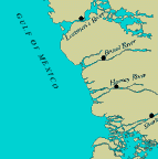
In 1996, the U.S. Geological Survey began a 4-year study of the flow and nutrient characteristics of three major streams that drain parts of the Everglades National Park. Each site was instrumented with an upward looking acoustic doppler current profiler, a water-level sensor, and two specific conductance sensors. Monthly discharge measurements are made with an accoustic doppler current profiler to develop discharge ratings. Nutrient data are collected monthly at each site. Flow, nutrient concentrations, and nutrient load data will provide part of the basic information needed to understand the hydrologic and water-quality characteristics for a part of the southwest coast of Florida. The analysis of these measurements will help characterize the current conditions for the three sites and explain the relation between upgradient water levels and southwest coastal stream flows, and the possible interaction between south- west coastal waters and the waters of Florida Bay. The data can also be used as input to hydrodynamic and water-quality models. ProposalsProject SummariesData
Metadata
PublicationsAbstracts
Fact SheetsPostersScientific Investigations Reports |
U.S. Department of the Interior, U.S. Geological Survey
This page is: http://sofia.usgs.gov/projects/index.php?project_url=nutrient_load
Comments and suggestions? Contact: Heather Henkel - Webmaster
Script last updated: 04 February 2009 @ 10:18 AM by BJM. Record creator: BJM. Record last updated by: BJM.