Skip Navigation
NOAA
weather.gov
National Weather Service Weather Forecast Office
Paducah, KY
Search for:
NWS
All NOAA
Home
Site Map
News
Organization
Local forecast by
"City, St" or Zip Code
Current Hazards
Watches / Warnings
Outlooks
U.S. Hazards
Hurricane Info
eSpotter
Severe Weather Briefings
Severe Weather Information
Current Conditions
Observations
Satellite Images
Rivers & Lakes AHPS
Precip Estimate
Snow Cover
CoCoRaHS Summary
Radar Imagery
Local Radar
Nationwide
Evansville
Hopkinsville
Forecasts
Activity Planner
Local Area
Aviation
Fire Weather
Graphical
Text Products
Audio Products
Rivers / Hydrology
AHPS / River Info
River Forecasts
Current Stages
Climate
Local
National
More...
Weather Safety
StormReady
Weather Radio
EMWIN
SKYWARN spotters
Local Information
Our Office
Coop Observer
Service Guide
Our Warning Area
Customer Service Workshop Findings
Emergency Manager Page
Education/Training
Science/Research
Weather Education
Past Weather Events
1925 Tri-State Tornado
1982 Marion Tornado
1957 Carter County MO Tornado
Model data
Contact Us
Webmaster
Feedback
Top News of the Day
Brief Tornado Touchdown in Southeast Graves and Calloway County KY on April 30th
Watches &
Warnings
Observations
Forecast Graphics
Rivers &
Lakes
Climate
Local Overview
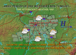
Click on the map below for the latest forecast.
Last map update: Tue, May. 5, 2009 at 8:29:55 pm CDT
Read watches, warnings & advisories
Zoom
Out
Flood Warning
Flood Watch
Hazardous Weather Outlook
Weather Story
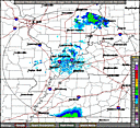
Radar
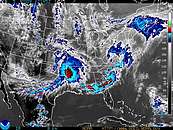
Satellite
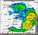
Weather Map
FORECAST-AT-A-GLANCE
PADUCAH
Tonight
Tstms
Likely
Lo
56 °F
Wednesday
Chance
Tstms
Hi
74 °F
Wednesday
Night
Mostly
Cloudy
Lo
60 °F
Thursday
Chance
Tstms
Hi
79 °F
Thursday
Night
Chance
Tstms
Lo
63 °F
Friday
Chance
Tstms
Hi
78 °F
EVANSVILLE
Tonight
Chance
Tstms
Lo
54 °F
Wednesday
Chance
Tstms
Hi
71 °F
Wednesday
Night
Mostly
Cloudy
Lo
58 °F
Thursday
Chance
Tstms
Hi
78 °F
Thursday
Night
Chance
Tstms
Lo
60 °F
Friday
Chance
Tstms
Hi
78 °F
CAPE GIRARDEAU
Quad State Outlook
Tuesday Night
River Flooding
Low
Thunderstorms
Low
Wednesday
Heavy Rain
Low
River Flooding
Low
Thunderstorm Winds
Low
Thunderstorms
Low
Click for risk level information.
CURRENT CONDITIONS
LOCATION
TIME[cst]
WEATHER
TEMP
DEWPT
HUMIDITY
WIND
PRESSURE
Cape Girardeau, MO
15:53
Fair
70ºF
54ºF
57%
S 8 mph
29.93 in
Carbondale, IL
15:52
Overcast
71ºF
55ºF
57%
S 6 mph
29.93 in
Evansville, IN
15:54
A Few Clouds
72ºF
51ºF
48%
SW 3 mph
29.94 in
Mount Carmel, IL
16:25
Partly Cloudy
74ºF
45ºF
35%
SW 7 mph
29.92 in
Mount Vernon, IL
16:35
Overcast
72ºF
52ºF
50%
SW 7 mph
29.94 in
Owensboro, KY
15:56
A Few Clouds
74ºF
54ºF
50%
SW 7 mph
29.95 in
Paducah, KY
15:53
Overcast
71ºF
53ºF
53%
SW 6 mph
29.94 in
Poplar Bluff, MO
15:53
Fair
70ºF
54ºF
57%
S 7 mph
29.93 in
CLICK ON LOCATION FOR THREE DAYS OF OBSERVATIONS
CLIMATE
TODAY'S CLIMATE STATISTICS
PADUCAH
EVANSVILLE
OBSERVED
HIGH: 73ºF at 1150AM
LOW: 52ºF at 529AM
HIGH: 75ºF at 200PM
LOW: 53ºF at 347AM
NORMAL
HIGH: 74ºF
LOW: 51ºF
HIGH: 74ºF
LOW: 50ºF
LAST YEAR
HIGH: 78ºF
LOW: 44ºF
HIGH: 74ºF
LOW: 43ºF
RECORDS
HIGH: 92ºF in 1959
LOW: 40ºF in 2005
HIGH: 93ºF in 1959
LOW: 36ºF in 1957
PRECIP
0.00" TODAY
1.28" MONTH TO DATE
0.00" TODAY
0.53" MONTH TO DATE
SUNRISE
&
SUNSET
MAY 5
SUNRISE: 556AM SUNSET: 748PM
MAY 6
SUNRISE: 555AM SUNSET: 749PM
MAY 5
SUNRISE: 549 SUNSET: 745PM
MAY 6
SUNRISE: 548AM SUNSET: 746PM
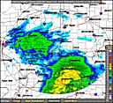
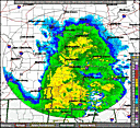
RADARS
PADUCAH RADAR
STANDARD
ENHANCED
EVANSVILLE RADAR
STANDARD
ENHANCED
HOPKINSVILLE RADAR
STANDARD
ENHANCED
QUICKLINKS
WEATHER
CLIMATE
RIVERS
SEVERE WEATHER INFORMATION
HAZARDOUS WEATHER OUTLOOK
REGIONAL WEATHER SUMMARY
STORM REPORT GRAPHIC
SEVERE WEATHER BRIEFS
E-SPOTTER
PAST WEATHER EVENTS
PAST 24 HOURS
LOCAL
NATIONAL
OBSERVED RIVER STAGES
FORECAST RIVER STAGES
RIVER INFORMATION
National Weather Service
Paducah, KY Weather Forecast Office
8250 Kentucky Highway 3520
West Paducah, KY 42086-9762
270-744-6440
Page Author: PAH Webmaster
Web Master's E-mail:
w-pah.webmaster@noaa.gov
Page last modified: 13-Jul-2007 9:52 PM UTC
Disclaimer
Credits
Glossary
Privacy Policy
About Us
Career Opportunities