
 |

| EAA | STAs | WCAs | Control Structures |
| Everglades Agricultural Area |

|
| Map showing location of the Everglades Agricultural Area (EAA), Stormwater Treatment Areas (STAs), and Water Conservation Areas (WCA). |
In the 1850’s, the state of Florida was selling cheap land to anyone who could drain it. Drainage and dredging of the peat soils in the northern Everglades continued through the 1920’s. Hurricanes and flooding in 1926 and 1928 caused thousands of deaths and the implementation of the Central and Southern Florida (C&SF) water management project in 1948. As part of the C&SF Project, the U.S. Army Corp of Engineers (USACE) constructed about 1,000 miles of canals, levees, gates, dams and pump stations. These structures were designed to protect against flooding, to prevent saltwater intrusion, and to provide water for agricultural irrigation and drinking water supplies.
The C&SF Project identified 800,000 acres of the northern Everglades as an area for agricultural development. The lands were drained and called the Everglades Agricultural Area (EAA). The EAA lies to the southeast of Lake Okeechobee. Crop production in the EAA includes sugarcane, winter vegetables (tomatoes, peppers, cucumbers, eggplant, Chinese vegetables), citrus, sod, sweet corn and rice. Canals are used throughout the EAA for water supply and flood control purposes. The four primary canals within the EAA are the Miami, North New River, Hillsboro and West Palm Beach Canals.
The Everglades Agricultural Area impedes the historic flow of water to the Everglades and adversely affects water quality. Soil subsidence, and fertilizers, pesticides, and insecticides found in agricultural runoff all contribute to decreased water quality.
To address phosphorus levels in "downstream" waters of the Everglades, the Everglades Forever Act (1994) mandated the construction of Stormwater Treatment Areas (man-made wetlands designed to remove excess nutrients from the water). The South Florida Water Management District (SFWMD) was directed to construct these STAs downstream from the primary canals of the EAA. The SFWMD will manage the STAs for optimal removal of nutrients and will restore historic sheet flow into tens of thousands of acres of the Everglades.
The Everglades Forever Act also mandated that farmers reduce phosphorus levels by 25 percent. While the farming community is meeting and exceeding the 25 percent phosphorus reduction, high levels of nitrogen still exist. These high levels of nitrogen produce algal blooms and decrease the amount of sunlight needed by submerged aquatic vegetation and coral reefs to survive.
Take a look at some of the agricultural activities found within the Everglades Agricultural Area.
| A photo gallery is available for this page. [Photos taken December, 1999 and April, 2000] |
| Sugarcane |
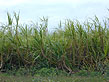 |
A close-up of sugarcane stalks south of Lake Okeechobee, just outside of South Bay along US 27. Sugarcane is a large tropical grass; therefore, the stalks have no branches, just sections of long leaves. [larger image] |
Sugarcane has been grown along the southeastern shore of Lake Okeechobee since the 1920s. It is one of the primary crops in the Everglades Agricultural Area.
The Florida sugarcane crop accounts for a little more than 1/2 of U.S. cane sugar production and 1/5 of U.S. total sugar production. Before being mechanically harvested, sugarcane fields are burned to remove dead leaves. Harvested cane is then brought to a sugarcane mill where juices are extracted from the stalks, mixed with lime and evaporated off until raw crystals form. Raw crystals become granulated sugar and liquid sugar at sugar refineries.
|
| Sugarcane Processing |

Looking east from US 98/441, about 5 miles south of Port Mayaca, beyond the dark, mucky soils of a harvested field, is a sugarcane processing plant.
[larger image] |
Drainage ditches like the one pictured directly to the right collect excess water during the summer rainy season. During the winter dry season, water flow is directed into the ditches and irrigation results from the seepage of water throughout the porous crop soils.
|
Looking east from US 98/441, approximately 3 miles south of Port Mayaca, beyond the drainage ditch are a sugarcane field and a processing plant in the far background.
[larger image] |
| Facing east from US 98/441, about 1/2 mile south of Canal Point, storm clouds shadow rows of young sugarcane that grow before a sugarcane processing plant. |

[larger image] |

[larger image] |
| Lake Okeechobee's Herbert Hoover Dike |

[larger image] |
Dead Australian melaleuca trees atop some artificial islands near Lake Okeechobee's shore. Australian melaleuca was introduced to Florida in the early 1900's. It now dominates the stands in which it grows and is moving in on many native plant communities.
The US Army Corps of Engineers (USACE) originally planted the Australian melaleuca trees on islands just inside the Herbert Hoover Dike. Due to their invasive nature, the USACE is killing the trees with pesticides and later clearing the dead trunks away.
|
| Rice |
Florida is a minor producer among the 7 states in the U.S. that produces rice. Rice is used as a rotational crop in the Everglades Agricultural Area. Flooding of the fields reduces soil pest populations and straw from the rice plant improves soil workability.
When plants are about 6 inches high the lands are flooded until the rice matures. Lands are then drained and the rice is harvested.
Due to Florida's long growing season, initial rice crops can produce a regrowth or ratoon crop. If a ratoon crop is wanted, the plants are allowed to regrow and the process begins again.
Initial crops take about 120 days to mature while ratoon crops take about 85 days.
|
| Rice Processing |

A rice mill located on State Road 80. [larger image] |
Rough rice that comes into the mill is passed through a series of sorting machines. Here, the conveyer belt is
separating the lighter-weight hulled (brown) rice from the heavier-weight unhulled rice. (After the hulls are removed from the rough rice, what remains is brown rice, with bran layers surrounding the kernels.) Unhulled rice is routed back to repeat the unhulling process and brown rice continues on to the polisher where it is rubbed together to remove the bran layer, resulting in white rice. |

Workers collect the packaged (rice) product and prepare it for shipment. [larger image] |
| Agricultural Water Management |
| A ditch excavation near the intersection of State Road 80 and Duda Road (top) shows muck soils overlying limestone bedrock. Limestone ditch spoils sit atop the muck layer (bottom).
Most farmers rely on these dark, rich, mucky soils for crop production. However, agricultural water management practices alternately cover and expose these soils and when muck is dry, it oxidizes and shrinks. Everglades Agricultural Area (EAA) soil subsidence rates have averaged about one inch per year. To reduce soil subsidence rates, recent water management practices involve elevated water tables to reduce oxidation.
Due to soil subsidence, it is predicted that agricultural practices in the EAA will diminish over time.
|

[larger image]

[larger image]
|

Culverts lying in excavated ditch. [larger image] |
Culverts are used to transport water from one location to another. |
|
Hacienda |

[larger image] |
A (former) hacienda located within Everglades Agricultural Area (EAA) lands. Today, very few people live in the EAA, but rather travel there daily to work. |
Related SOFIA Information
Below we have listed science projects and publications for studies that are being conducted, or have been conducted, in the vicinity of the Everglades Agricultural Area. Follow these links to read about each project and to see project-related publications and data.
Science Projects:
Related Publications:
TOP
|