 |
|
The Corps spent just 10 days here, but used Station Camp as a departure point for an overland trek to their first view of the Pacific Ocean and an exploration of the area. Together with nearby Dismal Nitch, Station Camp helps greatly to tell the Lewis and Clark story in Washington.
The Corps met “near disaster” at Dismal Nitch, to arrive “in full view of the ocian” at Station Camp. Also, both before and after Captains Lewis and Clark established Station Camp, the site was a vital and thriving Chinook Indian village.
For thousands of years, the Chinook people have lived along the Columbia River and their home near the river’s mouth was strategically located to provide abundant food, such as salmon and shellfish. In addition, the nearby forests were home to game animals and the grasslands and marshes provided ample materials for making shelter, clothing and trade and household goods. The river provided a way for Chinook traders to travel to the south shore and up and down the Columbia.
They developed a sophisticated, rich culture and enjoyed great success as traders. The waterway near Station Camp became a virtual trade “water highway.” During the 10 years before Lewis and Clark arrived overland at the this spot almost 90 trade ships from Europe and New England are documented to have crossed the Columbia River Bar to trade with Native Americans. These ships brought metal tools, blankets, clothing, beads, liquor and weapons to trade for beaver and sea otter pelts. By the time the Corps reached the site, the Chinook’s had moved to their winter village and this village was unoccupied. The explorers spent almost two weeks there.
|

|
| Courtesy of Cliff Vancura of Otak, Inc. |
This photograph is a view from the rip-rap shoreline at Station Camp
towards Cape Disappointment to the west. |
|
|
Several significant events took place, including the decision to spend the winter across the river, in what is now Oregon. It was Nov. 24, 1805, and the explorers desperately needed to lead the Corps to a winter campsite, one rich with game and near friendly tribes who would trade for supplies. A majority of the Corps, including the Indian woman Sacagawea and the African American York decided to cross the Columbia River to look for such a place. Because of this poll and decision, some historians call Station Camp “the Independence Hall of the American West.” It would be more than fifty years before African Americans could vote, and more than 100 years before the right was extended to women.
|

|
| Drawing by Roger Cooke, Courtesy of the Washington State Historical Society. |
| This is an artist’s depiction of the “The Vote” at Station Camp, when each member of the group had an equal voice in deciding where the expedition party would make winter camp. Drawing by Roger Cooke, Courtesy of the Washington State Historical Society. |
|
|
Today, the State of Washington is developing a riverfront park at Station Camp, focusing on the Chinook history, as well as telling the story of the Corps’ vote and the first viewing of the Pacific by the group. In 2005, archeologists found abundant physical evidence to support the importance of the site as a Chinook trade village. More than 10,000 artifacts were uncovered, including trade beads, plates, cups, musket balls, arrowheads, Indian fish net weights and ceremonial items. The European artifacts are from both before and after the Corps’ visit in 1805, and attest to the vitality of the Chinook social and economic life at the site. The enhanced visitors site should be completed by 2007. Station Camp eventually will encompass about 280 acres and be operated by the Lewis and Clark National and State Historical Parks.
|

|
| Courtesy of Otak, Inc. |
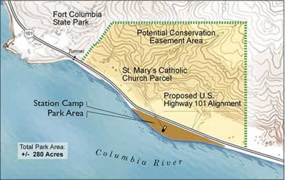
| This aerial photograph depicts the existing conditions at the Station Camp site with an overlay of the proposed realignment of Highway 101. The graphic illustrates the extent of the proposed highway realignment which creates an area for development of the Station Camp park site along the river. |
|

|
| Courtesy of Otak, Inc. |
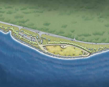
| This image is a schematic park design for the Station Camp site. The functional aspects of the park such as parking and restrooms are located west of the St. Mary’s Church while the interpretive areas of the park are located along pedestrian walkways east of the existing church. |
|

|
| Courtesy of Otak, Inc. |
| This map image is a representation of the proposed boundary for the Station Camp Unit of the Lewis and Clark National Historical Park. |
|
|
MAGIC MOMENTS: Storm watchers can take a front seat to the action at Station Camp.
DID YOU KNOW?: Clark called the spot “Station Camp” because it was his primary survey station to produce a detailed and accurate map of the mouth of the Columbia River and surrounding area. This was the most detailed and accurate map he made during the entire trip.
|

|
| Courtesy of Cliff Vancura of Otak, Inc. |
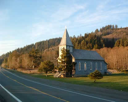
| This photograph is a view of the existing highway and the historic St. Mary’s Church at the Station Camp site. |
|
|  |  |
|
|

Destination: The Pacific
Creating a National Heritage Area at the Columbia Pacific
more... | | 
Fort Columbia (WA)
Fort Columbia, near Chinook, Washington is just a short distance from Station Camp and Dismal Nitch
more... | | 
Dismal Nitch (WA)
The explorers had all but lost hope at Dismal Nitch, just a short distance from their destination
more... | | 
Cape Disappointment (WA)
Cape Disappointment State Park, near Ilwaco, Washington
more... | |
|
|


