DOC
/
NOAA
/
NESDIS
/
OSDPD
/
SSD
Search OSDPD
Home
About US
About SSD
About OSDPD
Mission & Strategy
Disclaimer
Privacy Policy
Learn About Satellites
Product Areas
Atmosphere
-- Aerosol
-- Clouds
-- Ozone
-- Precipitation (Rain)
-- Radiation Budget
-- Soundings
-- Volcanic Ash
-- Winds
CoastWatch
Hazards
Imagery
-- Archives
-- Composites
-- Geostationary Server
-- Land
-- Ocean
-- OSEI
Land
-- Fire & Smoke
-- Snow & Ice
-- Surface & Hydrology
-- Vegetation
Ocean
-- Coral Bleaching
-- Ocean Color
-- Sea/Lake Ice
-- Sea Surface Height
-- Sea Surface Temperatures
-- Tropical Systems
Product List (A-Z)
Special Imagery
Geographical Information Systems (GIS)
-- Fires
-- Snow
Operational Special Events Imagery (OSEI) Site
-- Current Events
-- Dust Storms
-- Fire
-- Floods
-- Icebergs
-- Ocean Events
-- Severe Weather
-- Snow Cover
-- Storm Systems
-- Tropical Cyclones
-- Unique Imagery
-- Volcanoes
Geostationary
GOES Image Server
-- Composites
-- Land Sectors
-- Ocean Basins
-- OSEI
-- Tropical Floaters
-- Tropical Atlantic
-- Tropical Pacific
-- Severe Storms
Polar
Atlantic Composites
Pacific Composites
Satellite Services
Argos DCS
EMWIN
GEONETCast Americas
GOES DCS
LRIT
NOAA DRO Conference
NOAASIS
SARSAT
---- Satellite Information ----
GOES
-- Satellite Status
-- Special Bulletins
-- Eclipse Schedules
-- Dissemination Schedules
METEOSAT
MTSAT-1R
POES
-- Satellite Operations
-- Satellite Status
-- Pre-Processing
-- Dissemination Schedules
Original SSD Links
SSD Fire Products
Operational Special Events Imagery
Precipitation Products
Satellite Information
Snow and Ice Products
Tropical Products
Volcano Products & the Washington VAAC
Winds
Geographical Information System Products
Precipitation Products
Text Messages with Graphics (where available) :
Most Recent
SPENES from the
last 90 Days
Precipitation Product Links
(All)
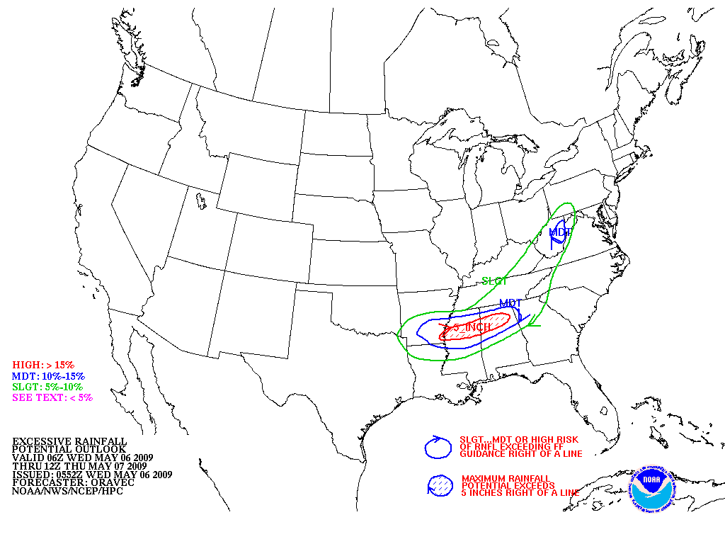
Excessive Rainfall:
Discussion
|
Graphic
Hydro-Estimator Products
CIRA Blended Total Precipitable Water (TPW)
Real Time Satellite Imagery
Individual WFO Sector Imagery
NEW!
GOES-East
GOES-West
North America
Atlantic Ocean
Pacific Ocean
Operational Significant Event Imagery
Flood Events
Severe Weather
Storm Events
Current Events
GOES East Image Archive
(Search)
GOES West Image Archive
(Search)
More Information:
The SSD Precipitation
Operation
Overview of Satellite Precipitation Estimates
(810k PowerPoint)
Recent Satellite Precipitation Endeavors
Papers, Posters and Presentations
Visit Comet Modules
Satellite Rainfall Hydro-Estimator
Operational Satellite Derived Tropical Rainfall Potential (TRaP)
Microwave Remote Sensing: Clouds, Precipitation, and Water Vapor
Indicates a link outside the U.S. Government.
Last Modified: August, 2008
Contact Information:
You are Here:
http://www.ssd.noaa.gov/PS/PCPN/index.html
SSD Webmaster

