|
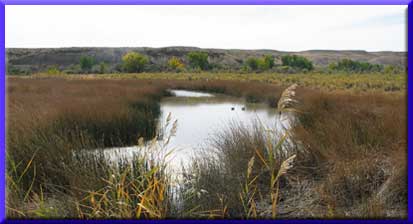
The Lower Duchesne River Wetlands Mitigation Project (LDWP)
is a federally mandated project to restore and enhance wetland,
riparian and supporting upland along the Duchesne River in the
Uinta Basin in Northeastern Utah. The underlying need for the Project
is to make up for impacts to wetland and wildlife habitat caused by
construction and operation of the Central Utah Project.
The Ute Tribe is a joint planning entity for
the mitigation project. Under agreements with the
Mitigation Commission and U.S. Department of the Interior,
the Tribe completed a feasibility study for protecting,
restoring or developing the lower Duchesne River wetlands.
Based on the study, the Commission, Department of
the Interior and Ute Tribe entered into an agreement
in 1998 to conduct additional investigations and National
Environmental Policy Act (NEPA) analysis. A final
Environmental Impact
Statement was released April 15, 2008 for a 30-day
public review.[Click
here to download the Lower Duchesne River
Wetlands Mitigation Project Final Environmental Impact
Statement - LDWP FEIS (17 MB)] [Click
here to download the Executive Summary for the LDWP
FEIS (3 MB)] The Mitigation Commission signed a LDWP
Record of Decision on May 22, 2008.
[You may click here to view it]. The Department of Interior signed its own LDWP Record of Decision on September 22, 2008. [Click here to view the DOI ROD]
The project area consists of 4,807 acres, of which
3,215 acres are Tribal Trust or Allotted land and
1,592 acres are private land. Private lands necessary
to complete the project will be acquired on a willing-seller
basis; the right of eminent domain will be preserved
only as a last resort in the event that every reasonable
effort to complete an acquisition on a willing-seller
basis fails. Acquiring lands through eminent domain
is controlled by federal regulation and policy and
is designed to protect both private landowner and
taxpayer.
The Project will be constructed over a seven year
period, at a minimum. Land acquisition will be among
the first activities initiated and will begin in the
Uresk Drain area, where the least amount of private
land is required for the project. Offers from willing
sellers in other project areas will be considered
any time those opportunities arise. Mosquito and weed
control measures also will be implemented upon initiation
of the project. Construction of wetland features,
including berms, wetland depressions and oxbow connections,
will proceed according to the success and schedule
of land acquisitions. Planting native riparian vegetation
will occur on a block-by-block basis, with each planting
block consisting of about a 120-acre area. Approximately
one planting block of riparian habitat will be planted
each year. All land disturbed during construction
of wetland features will be planted the same year
it is disturbed unless disturbances continue over
more than one year.
All potential mosquito-breeding habitats within project
boundaries will be treated for mosquitoes in accordance
with a Mosquito Control Plan (outlined
in Appendix G of the Final Environmental Impact Statement
- FEIS). Thus, 2,579 acres of mosquito-breeding
habitat will be treated, which is a significant increase
over what is treated currently. Noxious weed control
will also take place during all project phases. A
detailed weed control plan is part of the LDWP
FEIS in Appendix B. The Ute Tribe will implement
the Mosquito and Weed Control Plans using federal
funds, from the beginning of the project through project
operation and maintenance.
The Ute Tribe will manage Project lands as a special
use wetland wildlife natural resource area under the
Proclamation of the Tribal Wildlife Advisory Board
and Tribal Business Committee. The Tribe will be funded
for operation and maintenance of the Project. Specific
funding mechanisms will be detailed in Operating Agreements.
A detailed Comprehensive Conservation and Management
Plan that specifies management strategies, habitat
developments and permitted public uses will also be
developed. The primary management objective will be
to restore and maintain wildlife habitat. Public access
will be allowed for uses related to wetland-wildlife
resources. Recreational uses compatible with the overall
wildlife habitat goals will be allowed such as fishing,
hunting, environmental education, pedestrian use,
non-motorized use and wildlife observation. Prohibited
uses would include off-road motorized vehicle use.
As part of President Obama’s plan to help stimulate the lagging economy, the American Recovery and Reinvestment Act was passed in February, 2009. Recovery Act funds provided to the Mitigation Commission accelerate the opportunity to construct a building for storage and maintenance and repair of supplies and equipment used at the LDWP. The building would be located on lands owned by the Ute Indian Tribe near Myton, Utah. Other funded activities include noxious Russian olive removal and control. |