

 Data Set Name:
Thermal Anomalies & Fire 8-Day L3 Global 1km
Short Name:
MYD14A2

These images represent fires identified between May 1 - 8, 2007, an 8-day period during which the northern plains of the U.S. experienced numerous wildfires attributed to prolonged drought conditions. This image is the entire tile h11v04 along the Canadian border with North Dakota, Minnesota, and Wisconsin. Zooming in on the upper left quadrant of the tile, prominent fires surround North Dakota's Lake Sakakawea, a reservoir along the Missouri River.
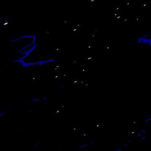
Using the MYD14A2 Fire Mask a color code was applied to highlight fires in yellow, water bodies in blue, and leaving land area in black. Each yellow pixel is 1km2.
MODIS Thermal Anomalies/Fire products are primarily derived from MODIS 4- and 11-micrometer radiances. The fire detection strategy is based on absolute detection of a fire (when the fire strength is sufficient to detect), and on detection relative to its background (to account for variability of the surface temperature and reflection by sunlight). Numerous tests are employed to reject typical false alarm sources like sun glint or an unmasked coastline.
MYD14A2 data are 8-day fire-mask composites at 1-kilometer resolution provided as a gridded level-3 product in the Sinusoidal projection. Science Data Sets include the fire-mask and algorithm quality.
The Aqua MODIS instrument acquires data twice daily (1:30 PM and AM), as does the Terra MODIS (10:30 AM and PM). These four daily MODIS fire observations serve to advance global monitoring of the fire process and its effects on ecosystems, the atmosphere, and climate.
Version-5 MODIS/Aqua Thermal Anomalies/Fire products are Validated Stage 1, meaning that accuracy has been estimated using a small number of independent measurements obtained from selected locations and time periods and ground-truth/field program efforts. Although there may be later improved versions, these data are ready for use in scientific publications.
Change Points of Interest
- Internal HDF compression reduces products to ~5% of their uncompressed size
- SDS "most confident detected fire" renamed as "FireMask"
- Reduced 32-bit QA to simpler 8-bit layer
- Added global HDF attributes to simplify use of tile-level QA
- More: Collection 5 Change Summary for MODIS Active Fire Algorithm and Products (PDF)
Overview
Data Set Characteristics
| Temporal Coverage | July 4, 2002 - |
| Area | ~10 x 10 |
| File Size | ~0.4 MB |
| Projection | Sinusoidal |
| Data Format | HDF-EOS |
| Dimensions | 1200 x 1200 rows/columns |
| Resolution | 1 kilometer |
| Science Data Sets (SDS HDF Layers) | 2 |
Links
External Product References
User Guide (PDF)Algorithm Theoretical Basis Document (PDF)
Accuracy (MODIS Land Validation Web Site)
Layers
Layer Specifications and QA/QC Descriptions
Science Data Sets for MODIS/Aqua Thermal Anomalies/Fire 8-Day L3 Global 1km SIN Grid V005 (MYD14A2):
|
Science Data Sets (HDF Layers) (2) |
UNITS |
BIT TYPE |
FILL |
VALID RANGE |
|---|---|---|---|---|
| Fire mask | Class | 8-bit unsigned integer | 0 | 0–9 |
| QA | Bits | 8-bit unsigned integer |
Policies
Please find the current MODIS-related Data Redistribution and Pricing policies on the MODIS Policies Section of this Web Site
LP DAAC Acknowledgement and Citations Policy
In the event that data distributed from the Land Processes DAAC are incorporated into your research, please supply the following acknowledgment within your published work: "These data are distributed by the Land Processes Distributed Active Archive Center (LP DAAC), located at the U.S. Geological Survey (USGS) Earth Resources Observation and Science (EROS) Center (lpdaac.usgs.gov)." If possible, please e-mail or send us reprints/citations of papers or oral presentations based on data obtained from the LP DAAC (see below for mailing address and e-mail address). This will help us to stay informed of how the data are being utilized.
LP DAAC User Services
U.S. Geological Survey (USGS)
Earth Resources Observation and Science (EROS) Center
47914 252nd Street
Sioux Falls, SD 57198-0001
Get Data
Data Access Tools
The complete data record for this product is available through the WIST and GloVis search and order interfaces. A partial record is available on-line through the Data Pool.
Please find links to (and information about) these data access tools on the Get Data Section of this Web Site.
Help
Contact Information
U.S. Geological Survey (USGS)
Center for Earth Resources Observation and Science (EROS)
47914 252nd Street
Sioux Falls, SD 57198-0001
| Phone Number: | 605-594-6116 |
| Toll Free: | 866-573-3222 |
| 866-LPE-DAAC | |
| Fax: | 605-594-6963 |
| Email: | lpdaac@eos.nasa.gov |
| Web: | http://lpdaac.usgs.gov |
- 47914 252nd Street
- Sioux Falls, SD 57198-0001
- Voice: 605-594-6116
- Toll Free: 866-573-3222
- Fax: 605-594-6963
- LPDAAC@eos.nasa.gov

![]() U.S. Department of the Interior |
U.S. Geological Survey
U.S. Department of the Interior |
U.S. Geological Survey
URL: https://lpdaac.usgs.gov/lpdaac/products/modis_products_table/thermal_anomalies_fire/8_day_l3_global_1km/v5/aqua
Page Contact Information: custserv@usgs.gov
Page Last Modified: November 24, 2008