
USGS/Cascades Volcano Observatory, Vancouver, Washington
Alaska Volcanoes and Volcanics
Maps and Graphics, etc.
-
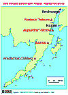 [Map,15K,InlineGIF]
Location Map: Volcano Deformation Project Volcanoes
-- Iwatsubo, 1996
-
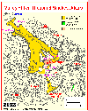
 [Map,21K,InlineGIF]
Augustine Island Volcano
-- Modified from: Waitt and Begét, 1996,
USGS Open-File Report 96-516
-
 [Map,18K,InlinedGIF]
Augustine Island - USGS/CVO Geodetic Network
-- Modified from: E. Iwatsubo, 1996
-
 [Map,30K,InlineGIF]
Location map for Novarupta and the Valley of Ten Thousand Smokes,
Katmai National Park, Alaska,
showing the 120-cubic-kilometer extent of the 1912 ash-flow sheet
-- Modified from: Hildreth, 1983
-
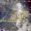 [Image,84K,InlineJPG]
Annotated NASA Image:
Katmai Vicinity, including the Valley of Ten Thousand Smokes, Alaska,
August 1989
-- NASA Photo, courtesy
NASA Earth From Space;
Modified with text by USGS/CVO.
Return to:
[CVO's Alaska Volcanoes and Projects Menu] ...
[MORE Annotated NASA Images]

Use of CVO Material and Copyright Information
URL for CVO HomePage is:
<http://vulcan.wr.usgs.gov/home.html>
URL for this page is:
<http://vulcan.wr.usgs.gov/Volcanoes/Alaska/Graphics/framework.html>
If you have questions or comments please contact:
<GS-CVO-WEB@usgs.gov>
03/25/02, Lyn Topinka
 Link to: Alaskan Volcano Observatory Website for MORE Maps and
Graphics
Link to: Alaskan Volcano Observatory Website for MORE Maps and
Graphics