Woods Hole Science Center
Duxbury-Hull | ||||||||||||
|
Geologic Mapping Home News and Updates Massachusetts Seafloor Mapping Cooperative About the Cooperative Nahant-Gloucester Boston Harbor Cape Ann - Salisbury Beach Duxbury-Hull Northern Cape Cod Bay Buzzards Bay & Vineyard Sound Other Massachusetts Mapping Stellwagen Bank Western Mass Bay Mass Bay Disposal Site Outer Cape Cod Quicks Hole Woods Hole Ocean Management Mapping Technology Bibliography of Maps Selected Links Cruises Completed Upcoming |
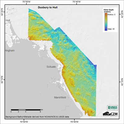
The geologic framework of the Massachusetts inner continental shelf between Duxbury and Hull has been shaped by a complicated history of glaciation, deglaciation, and changes in relative sea level. New geophysical data (swath bathymetry, sidescan sonar and seismic-reflection profiling), sediment samples, and seafloor photography provide insight into the geomorphic and stratigraphic record generated by these processes. Approximately 205 km² (80 mi²) of shallow seafloor were mapped, focusing on nearshore areas from the coast out to water depths of about 35 m (115 ft). The maps were produced as part of a cooperative mapping program between the U.S. Geological Survey (USGS) and Massachusetts Office of Coastal Zone Management (CZM). Mapping data was also contributed by the National Oceanic and Atmospheric Administration (NOAA). Accurate depictions of seafloor geology are an important first step toward understanding the type, distribution, and quality of subtidal marine habitats in the Massachusetts coastal ocean. The main objective is to support marine resource managers charged with making decisions on the use and protection of ocean resources. A companion report (in preparation) will contain descriptions of the data collection, processing, and analysis procedures used to create the maps, and GIS databases with all the geophysical and ground-validation data collected as part of this study.
Project Status: In progress
For more information: | |||||||||||