Sometimes one has to look backward in order to move forward. This is certainly the case with wildfire. As land managers grapple with the complexity of issues accompanying ecosystem restoration and management, fire histories can help them understand natural fire regimes and how they affected and maintained wildland ecosystems before Europeans settled the American West.
Working with collaborators Tom Swetnam of the University of Arizona Laboratory of Tree-Ring Research, Scott Anderson of Northern Arizona University, and others, USGS scientist Craig Allen has been developing landscape-level fire histories in the Jemez and Sangre de Cristo Mountains of northern New Mexico. These histories are compiled using charcoal deposits from bogs, historic fire suppression records, and tree-ring reconstructions of fire and precipitation. Allen also conducts collaborative research on the ecology of modern fires, including follow-up studies on the effects of the 1977 La Mesa Fire and ongoing work on tree growth, nitrogen-cycle/fire interactions, and fire effects on elk and Mexican spotted owls.

Charcoal sediments from a 5 m core collected from Alamo Bog in the central Jemez Mountains indicate essentially continuous fire activity dating back almost 9,000 years. Charcoal is absent in the top 25 cm of the core, which represents the years since about 1880. This is the biggest fire gap in this long charcoal record.
About 5,200 historic fires have been mapped in the Jemez Mountains for the period 1909-1996 from administrative records of local land-management agencies. Records show that lightning caused 75% of these recorded fires. The high frequency of lightning ignitions leaves climate and fuel conditions as the main drivers of fire dynamics in the Southwest.
Thousands of fire scars from more than 600 dated tree-ring samples show that, prior to about AD 1900, intervals between surface fires ranged from 5 to 25 years across much of the Jemez Mountains. Although variation in past fire regimes depended upon local conditions, fire activity commonly occurred over extensive areas. Major fire years were clearly associated with drought conditions, while wet periods recorded little fire activity.
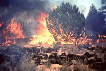
Abrupt declines in fire frequency occurred throughout the Jemez Mountains in the late 1800s, likely due to overgrazing-induced suppression of surface fires as livestock ate the grassy surface fuels. After 1910, active fire suppression began in earnest, and nearly a century of suppression has led to landscape-wide buildups of woody fuels. As a result, the frequency and severity of wildfire activity has been escalating. In particular, the size of stand-replacing crown fires has increased markedly in most forest types. The prevalence of drought conditions across the Southwest since 1996 has exacerbated the severity of recent fires.
Scientific characterizations of fire histories and associated
vegetation changes from the Jemez Mountains are being used to support
restoration of less hazardous and more sustainable ecological conditions
in the forests of this region. Nearby land managers using this information
for forest thinning and prescribed burning projects include the National
Park Service, Los Alamos National Laboratory, USDA Forest Service, Valles
Caldera National Preserve, Bureau of Land Management, Los Alamos County,
and the City of Santa Fe, as well as a number of Native American pueblos.
In addition, this fire history research has helped provide impetus to
the ongoing establishment of the Jemez Mountains as one locus for the
national Fire Learning Network coordinated by The Nature Conservancy.
|
For more information, contact:

![]() U.S. Department of the Interior | U.S. Geological Survey
U.S. Department of the Interior | U.S. Geological Survey
URL: http://www.fort.usgs.gov/resources/research_briefs/Callen_fire.asp
Page Contact Information: AskFORT@usgs.gov
Page Last Modified: 8:01:01 PM
