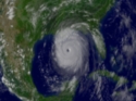
 | ImageHurricane Katrina
This GOES-12 1 km visible satellite image was taken on August 28, 2005, when Hurricane Katrina was at its maximum intensity of Category 5. | 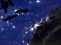 | ImageThe 2003 Blackout (August 13)
The Northeast Blackout of August 14, 2003 caused widespread loses of electrical power to the Northeastern and Mid-Western United States, and parts of Ontario, affecting over 40 million people. This image from the U.S. Air Force DMSP satellite shows the night time lights of the region on August 13, 2003. (more...) | |
|
|