HAZUS News
- SAVE THE DATE! 3rd Annual HAZUS Conference
- March 2009 Issue of Hot Zone is Available
- HAZUS Posters Selected for the 2009 ESRI Map Book
- HAZUS for the International Community
- Florida Implements CDMS Web Portal Project
- University of Utah Implements Sugar House Community Earthquake Loss Project
- HAZUS-MH Used to Support Hurricane Ike Operations
- Comprehensive Data Management System (CDMS) Version 2.0 is available from FEMA
- FEMA Introduces HAZUS-MH Training and Credentialing Program
- Summary of HAZUS-MH Databases
- FEMA Concludes a Successful 2008 Annual HAZUS Users Conference
- Updated Annualized Earthquake Loss Study (FEMA 366) Now Available
- HAZUS-MH Used in Two Integrated Emergency Management Courses (IEMC)
SAVE THE DATE! 3rd Annual HAZUS Conference
3rd Annual HAZUS Conference - Connecting the Pieces for Mitigation
August 10-12, 2009
Marriott Raleigh Crabtree Valley Hotel
Raleigh, North Carolina
Who Should Attend: New, experienced and interested users of HAZUS-MH, first responders, local government decision makers, planners and GIS specialists.
On the Agenda: The sharing of information concerning effective approaches for using HAZUS to support decision-making at all levels of government.
Call for Speakers: Suggested topics include: the role of HAZUS in risk identification and communication, HAZUS application in estimation and mitigation planning, HAZUS and human-caused hazards, and innovative approaches to decision making.
The deadline for submission of abstracts is April 15, 2009.
To submit an abstract, please e-mail Beth Miller Howser at HAZUSuser@ pbsj.com with the subject line: HAZUS Speaker Proposal and provide the following information:
• Proposed name of session
• Session format (presentation, workshop, panel discussion, etc.)
• Session description
• Contact information (including name, title, organization, phone number, and e-mail)
Registration: More information on registration is coming soon. For more information, please contact Beth Miller Howser at HAZUSuser@pbsj.com.
March 2009 Issue of Hot Zone is Available
The March issue of FEMA’s HAZUS Hot Zone newsletter contains information about Using HAZUS-MH to Support Preparedness for Hurricane Ike; HUG News; 3rd Annual HAZUS Conference -- Connecting the Pieces for Mitigation Information; HAZUS Training Information; and HAZUS Conference Events in 2009. Download the latest issue or click here to find previous issues of Hot Zone.
HAZUS Posters Selected for the 2009 ESRI Map Book
Published annually since 1984, the ESRI Map Book series is dedicated to acknowledging the important and innovative accomplishments of Geographic Information System (GIS) users around the world. Each volume of the ESRI Map Book showcases a small portion of the work presented at the Map Gallery exhibition at the annual ESRI International User Conference. For 2009, two HAZUS posters have been chosen for Volume 24 of the book: “HAZUS evaluation of 1906 magnitude earthquake in today's environment: Displaced Households” and “HAZUS valuation of 1906 magnitude earthquake in today's environment: Economic Loss.”
View additional HAZUS maps and posters here: http://www.fema.gov/plan/prevent/hazus/hz_maps.shtm.
HAZUS for the International Community
In response to the growing interest in HAZUS in the international community, a new link has been added to this web site that highlights key issues and steps that interested nations would have to take as part of a feasibility study for the international application of HAZUS. Click here for more information.
Florida Implements CDMS Web Portal Project
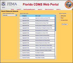
Florida became the second state, following South Carolina, to take training and implement the Comprehensive Data Management System (CDMS) Web Portal. The CDMS is a tool developed by FEMA to support the integration of locally developed inventory data into the HAZUS-MH loss estimation process. Specifically, the CDMS has three interrelated functions:
-
Support transfer of data into and out of the major master statewide databases
-
Provide validation of new data into the system
-
Allow users to query and print information within the system
The functionality of the Web Portal is the same as the desktop version. By requiring very little software and no physical installation, the Web Portal will enable the user-base to grow at a steady pace. Read more about this story.
University of Utah Implements Sugar House Community Earthquake Loss Project
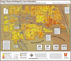
Stuart Moffatt from the University of Utah led a team of colleagues in the development of the Sugar House Community Earthquake Loss Estimation Project, an innovative initiative to estimate losses to this historic community on the Wasatch Front from a magnitude 7.0 earthquake. As stated by Moffatt, "We live on top of a fault in an area where a large percentage of the building stock is post-war brick-on-brick….we wanted to prepare a detailed map to help people see the potential loss we could suffer in our neighborhood." This was accomplished by using the HAZUS-MH Advanced Engineering Building Module (AEBM) to perform a Level 3 analysis of Sugar House parcels. The product of this project is a very detailed map that shows the vulnerability of the community at the parcel level, which is being used to promote seismic safety. View larger image of poster.
HAZUS-MH Used to Support Hurricane Ike Operations
As Hurricane Ike approached landfall in southeast Texas on September 13, 2008, officials at FEMA’s Mapping and Analysis Center (MAC) were in daily contact with HAZUS subject matter experts. FEMA’s HAZUS-MH team generated a suite of map-based products following each National Hurricane Center (NHC) advisory. For planning purposes, a key HAZUS-MH output is Estimated Maximum Sustained Wind Speeds. When used in conjunction with surge analysis, this template presents a useful snapshot of the exposure of the population and essential facilities to high winds and storm surge from Hurricane Ike. The ability to depict estimated damages on a regional (multi-county) scale is an added advantage. Find out how HAZUS-MH was used to support the Ike response operations. Read the full story. Download this story in PDF format.
Comprehensive Data Management System (CDMS) Version 2.0 is available from FEMA
FEMA has just released the CDMS Version 2.0, a complimentary tool to HAZUS-MH MR3 that provides users with the capability to update and manage statewide datasets, which are currently used to support analysis in HAZUS-MH. CDMS greatly simplifies and streamlines the process for updating statewide datasets, and represents an important milestone in the ongoing development of the HAZUS-MH technology. CDMS replaces two HAZUS-MH tools - InCAST and the Building Inventory Tool (BIT). Read about CDMS. Download CDMS Version 2.0.
FEMA Introduces HAZUS-MH Training and Credentialing Program
FEMA is launching a new initiative that recognizes emergency managers, GISThis new initiative, which was unveiled at the 2008 Annual HAZUS-MH Users Conference, provides recognition to HAZUS-MH users who have achieved a higher level of knowledge and expertise in one or more of the models. Emergency managers and GIS
demonstrated a proficiency in the use of the model, including an understanding of the underlying data structure. The HAZUS-MH Practitioner designation is given to users of the model who have also completed courses in the use of HAZUS-MH for disaster operations, risk assessment or mitigation planning.
The HAZUS-MH training and credentialing initiative is an important development in ongoing efforts to increase technical capacity in the use of HAZUS-MH. It will enable FEMA and the states to identify and quantify the distribution of HAZUS-MH expertise across the nation, important factors in strategic planning for HAZUS-MH.
Read more about the specialized training program.
Summary of HAZUS-MH Databases
One of the truly unique attributes of HAZUS-MH is the national inventory of hazard data, “point data” (e.g. essential facilities) and aggregated data on the general building stock. The Summary of HAZUS-MH Databases provides a very useful reference for these databases.
FEMA Concludes a Successful 2008 Annual HAZUS Users Conference
The recently concluded 2008 Annual HAZUS-MH conference brought together a diverse audience of approximately 300 emergency managers, model developers, GIS professionals, educators and risk management specialists to share expertise and experience in the development and use of HAZUS-MH. This year’s conference coincided with the release of the Comprehensive Data Management System (CDMS), a significant
milestone in the ongoing development of HAZUS-MH.
As part of the conference, Eric Berman, HAZUS Program Manager, was pleased to present the 2008 HAZUS User Awards. The awards are utilized to exemplify the outstanding work of organizations and individuals who have accelerated the awareness and use of the HAZUS program. Read about the 2008 HAZUS Award Recipients.
Updated Annualized Earthquake Loss Study (FEMA 366) Now Available
The recently updated HAZUS-MH Estimated Annualized Earthquake Losses for the United States (FEMA 366) can be downloaded from FEMA's website. HAZUS-MH was used in the preparation of the Annualized Earthquake Loss, which estimates seismic risk in all regions of the United States by using two risk indicators:
1. Annualized Earthquake Loss (AEL), which is the estimated long-term value of earthquake losses to the general building stock in any single year in a specified geographic area; and
2. Annualized Earthquake Loss Ratio (AELR), which expresses estimated annualized loss as a fraction of the building inventory replacement value.
This study is an important contribution to our understanding of the earthquake risk in the United States, and in ongoing efforts to promote seismic safety through the National Earthquake Hazards Reduction Program (NEHRP).
HAZUS-MH Used in Two Integrated Emergency Management Courses (IEMC)
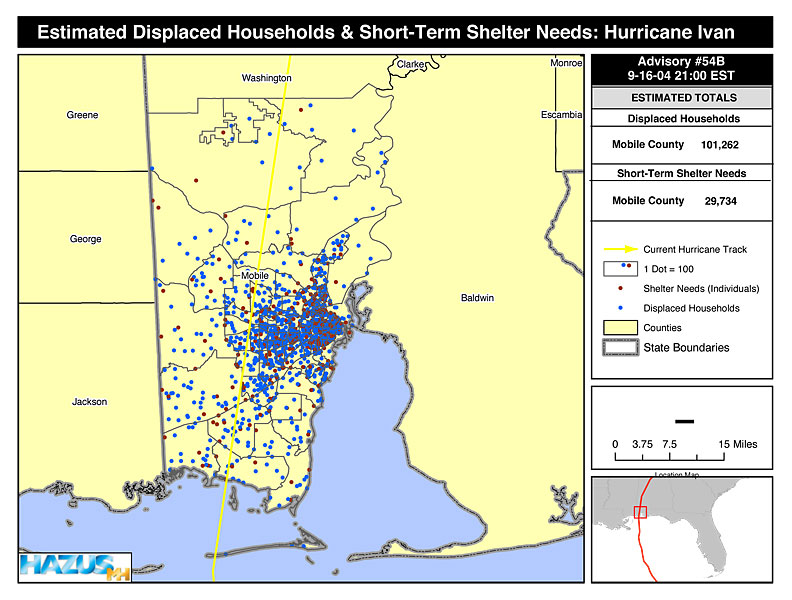
HAZUS-MH was successfully used in two Integrated Emergency Management Courses/Hurricane Recovery and Mitigation – one that focused on South Carolina and the other on Mobile, Alabama. These courses bring together State and local officials from the “study area” to develop and implement recovery and mitigation strategies following a major disaster.For these courses, HAZUS-MH was used to develop two scenario events:
 1) Hurricane Alonzo, a Category 3 event that reached landfall southwest of Horry County in South Carolina, and 2) Hurricane Daphney, a Category 4 hurricane that followed the same track as Hurricane Ivan in 2004, impacting southern Alabama and the Florida panhandle.
View larger Estimated Peak Gusts Wind Speeds: Hurricane Alonzo map graphic (64 k).
For both exercises, HAZUS-MH depicted the hurricane paths and extent of
 wind
wind HAZUS-MH is well suited for community or state-based hurricane exercises. The loss estimates enable response and recovery officials to delineate the extent of damage, and to scale resource requirements to support recovery.
For additional information on how HAZUS-MH can be used to support response and recovery operations, contact Tom Durham at TSDurham@PBSJ.com.
Download Plug-in
Some of the links on this page require a plug-in to view them. Links to the plug-ins are available below.
Last Modified: Thursday, 19-Mar-2009 16:32:14 EDT
Fast Facts
Since the late 1990s, HAZUS has been used to support analysis of shelter requirements, displaced households, and residential losses from earthquakes, hurricane winds, and floods. This analysis has important potential applications for FEMA’s Individuals and Households Program (IHP) applications include determining the exposure of population to hazard impacts (hurricane winds, storm surge, ground shaking); and estimations such as the number of IA Preliminary Damage Assessment Teams required for a disaster, residential damage, short-term shelter requirements, or number of displaced households.
 Email Updates
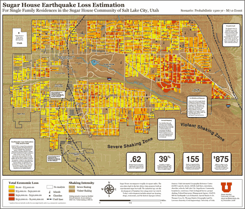