On Board the OSV BOLD: Transition
Tuesday, February 24th, 2009| For more than a month, EPA’s Ocean Survey Vessel (OSV) Bold is studying the health of the waters around Puerto Rico and the U.S. Virgin Islands. EPA scientists and non-scientists will blog about their research and what it’s like to live and work at sea. |
About the author: Charles LoBue serves as the chief scientist and diver for the US Virgin Island leg of the OSV BOLD voyage. He is an environmental scientist in EPA Region 2 in New York City.
Feb. 23, 2009 - 3:00 pm (Day 15)
As the Puerto Rico leg of the OSV BOLD’s survey winds down, the U.S. Virgin Islands leg is beginning. We’re staffed, equipped and ready to begin a nearly three-week survey to assess the condition of coral reefs around St. Thomas and St. John. We’ve reassembled this experienced team of divers and scientists to resume the work that began in 2006. Back then, EPA worked with V.I. Department of Planning and Natural Resources (DPNR) in St. Croix to initiate an inventive new coral monitoring program developed by EPA’s Office of Research and Development. Our team will include divers from EPA, DPNR, U.S. Fish and Wildlife Service, and The Nature Conservancy.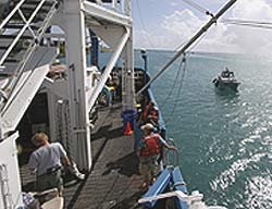
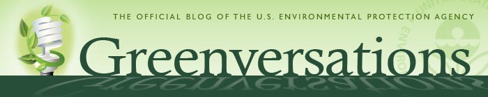
The waters that we are working in this year are new to us, which adds an element of adventure. Our plan is to perform strategic observations and measurements of corals and other biota at 60 stations around the islands. Water and sediment sampling will add to the mix. Each morning, we will assign dive teams to three small boats, which will be dispatched to different observation stations.
 Here’s the basic process once we’re in the water. When a dive team arrives at a station, a snorkel reconnaissance is performed to assess whether the site has suitable coral cover. The team then enters the water and lays a 25-meter transect line to mark the domain of the observations. The team then makes a general assessment of the cover types, measures topography, counts other invertebrate species, and collects sediment and water samples throughout the transect area. Coral experts will identify every hard coral colony encountered within a meter of the transect line, measure its dimensions, and judge how much of it is thriving.
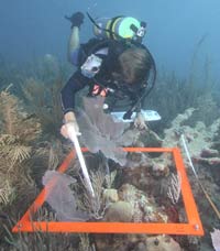
 When the team returns to the OSV BOLD, data are entered into a computer for analyses and water samples are processed. This will go on for the duration of the survey.
Sure it may seem to be a cookie-cutter process, but the best laid plans are always at the mercy of the weather and sea condition. Of course, underlying all this field work is the logistics and procedures needed to maintain to safe diving operations. Our challenge is to find and assess 60 suitable stations over some 50 some-odd miles of coast around the two islands and assorted cays. So here’s to blue skies, calm seas, and healthy coral.
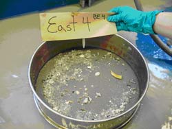 We broke up into three teams. Two teams sampled in the RHIBS and one team stayed on board the OSV BOLD to process the sediment samples collected by the other teams. We will analyze the sediment samples of sand, silt and clay for grain size, total organic carbon (TOC), and benthic community analyses (organisms that live at the bottom of the ocean). The grain size and TOC samples are placed into a refrigerator and will be shipped to our lab for analysis. The benthic community samples are placed into a sieve, small round pan with a 0.02 inch (0.5 mm) screen on the bottom.
 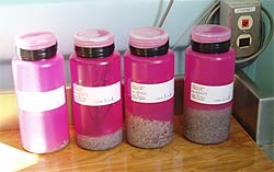 The remaining material is gently scooped into a plastic container. The contents are preserved and stained, which allows for easier identification of any organisms. We then wrap electrical tape around the lids to further prevent leakage of the preservative. Our results will be utilized to help better protect and preserve the coral reefs and their associated ecosystems.
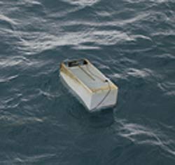 I have been wondering ever since how this refrigerator ended up in the midst of Puerto Rico’s north coast. Could heavy rains have carried it from somewhere up in the mountains to the ocean? Was it not properly disposed of – perhaps just thrown into an illegal dump next to the coast that had eroded with time? We will never know for certain, but one thing is clear – in addition to presenting a navigational hazard, this refrigerator must have leaked all of its contents into the ocean, affecting marine life.
 So, getting back to my 3rd graders…I give each student a fake $1 million dollar bill, a “piece of land,” and colored pencils to draw what they would build on their riverfront property with their million dollars. The idea is that each student’s piece of land is part of the ecosystem and what one person does on their land can affect others as the pieces are assembled. The activity is called
  Each week we write about the science behind environmental protection.
 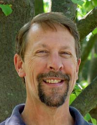 I gazed over the podium at the Portuguese faces waiting to hear how the U.S. EPA measures the health of U.S. estuaries and coastal oceans. A conference in the Azores was comparing the approaches used by the U.S. and the European Union (EU). A few opening pleasantries quickly exhausted my what-you-can-learn-from-ten-CDs knowledge of the Portuguese language and I switched to English.