Ocean Dredged Material Disposal Sites (ODMDS) in the Southeast
Most of the dredged material disposed in the ocean is disposed
at ocean dumping sites specifically designated by EPA for dredged material disposal
under section 102 of the Marine Protection, Research, and Sanctuaries Act (MPRSA).
EPA designated sites are to be used for ocean disposal to the extent feasible.
All ocean dumping sites are required to have a site management and
monitoring plan (SMMP). Appropriate management of ocean dumping sites is aimed
at assuring that disposal activities will not unreasonably degrade or endanger
human health, welfare, the marine environment or economic potentialities.
- regulating the times, the quantity, and the physical/chemical characteristics of dredged material that is dumped at the site;
- establishing disposal controls, conditions, and requirements to avoid and minimize potential impacts to the marine environment; and
- monitoring the site environs to verify that unanticipated or significant adverse effects are not occurring from past or continued use of the disposal site and that permit terms are met.
Disposal Sites in the Southeast
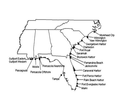
|
Alabama |
Mobile |
|---|---|
| Florida |
Canaveral Harbor Fernandina Beach Fort Pierce Harbor Jacksonville Miami Palm Beach Harbor Pensacola Nearshore Pensacola Offshore Port Everglades Harbor Tampa |
| Georgia |
Brunswick Harbor Savannah |
| Mississippi |
Gulfport Eastern Site Gulfport Western Site Pascagoula |
| North Carolina |
Morehead City New Wilmington Wilmington |
| South Carolina |
Charleston Georgetown Harbor Port Royal |
You will need Adobe Reader to view some of the files on this page. See EPA's PDF page to learn more.
Alabama Dredged Material Disposal Sites
Mobile
| Location: | 30°10'00''N., 88°07'42''W.; 30°10'24''N., 88°05'12''W.; 30°09'24''N., 88°04'42''W.; 30°08'30''N., 88°05'12''W.; 30°08'30''N., 88°08'12''W. |
|---|---|
| Size: | 4.8 square nautical miles |
| Depth: | Average 14 meters |
| Primary use: | Dredged material |
| Period of use: | Continuing use |
| Restriction: | Disposal shall be limited to dredged materials which meet the Ocean Dumping Criteria |
Florida Dredged Material Disposal Sites
Canaveral Harbor
| Location: | 28°20'15''N., 80°31'11''W.; 28°18'51''N., 80°29'15''W.; 28°17'13''N., 80°30'53''W.; 28°18'36''N., 80°32'45''W. Center coordinates: 28°18'44''N., 80°31'00''W. (NAD 27) |
|---|---|
| Size: | 4 square nautical miles |
| Depth: | Range 47 to 55 feet |
| Primary use: | Dredged material |
| Period of use: | Continuing use |
| Restriction: | Disposal shall be limited to suitable dredged material from the greater Canaveral, Florida, vicinity |
| Management Plan: | Canaveral ODMDS Site Management and Monitoring Plan (SMMP) - 2001 (PDF) (71 pp, 3.6MB) |
|
Reports: |
Spatial Analysis of Sediment Grain Size - 2005 (PDF) (20 pp, 1.1MB) Ocean Current and Wave Measurements - 2005 (PDF) (48 pp, 1.8MB) |
Fernandina Beach
| Location: | 30°33'00''N., 81°16'52''W.; 30°31'00''N., 81°16'52''W.; 30°31'00''N., 81°19'08''W.; 30°33'00''N., 81°19'08''W. |
|---|---|
| Size: | Four square nautical miles |
| Depth: | Average 16 meters |
| Primary use: | Dredged material |
| Period of use: | Continuing Use |
| Restriction: | Disposal shall be limited to dredged material which meets the criteria given in the Ocean Dumping Regulations in 40 CFR part 227 |
| Management Plan: |
Fernandina Beach ODMDS SMMP - 1998 (PDF) (16 pp, 584K)
Fernandina Beach ODMDS SMMP Addendum #1 - 2001 (PDF) (10 pp, 217K) |
| Reports: |
Fernandina Beach ODMDS Bathymetry (2001-2005) (PDF) (1 p, 267K) Fernandina Beach ODMDS 2005 Trend Assessment Survey (PDF) (56 pp, 2.1MB) |
Fort Pierce Harbor
| Location: |
27°28'00''N., 80°12'33''W.; 27°28'00''N., 80°11'27''W.; 27°27'00''N., 80°11'27''W.; and 27°27'00''N.,80°12'33''W. |
|---|---|
| Size: | 1 square nautical mile |
| Depth: | Average range 40 to 54 feet |
| Primary use: | Dredged material |
| Period of use: | Continuing use |
| Restriction: | Disposal shall be limited to suitable dredged material from the greater Fort Pierce Harbor vicinity. All dredged material consisting of greater than 10% fine grained material (grain size of less than 0.047mm) by weight shall be limited to that part of the site east of 80°12'00''W. and south of 27°27'20''N. |
| Management Plan: |
Fort Pierce ODMDS SMMP - 2000 (PDF) (23 pp, 1MB) |
|
Reports: |
Benthic Surveys: 1992 and 1999 (PDF) (54 pp, 5.2MB)
Sidescan Sonar Survey - 1999 (PDF) (1 p, 684K)
|
Jacksonville
| Location: | 30°21'30''N., 81°18'34''W.; 30°21'30''N., 81°17'26''W.; 30°20'30''N., 81°17'26''W.; 30°20'30''N., 81°18'34''W. |
|---|---|
| Size: | One square nautical mile |
| Depth: | Ranges from 12 to 16 meters |
| Primary use: | Dredged material |
| Period of use: | Continuing use |
| Restriction: | Disposal shall be limited to dredged material from the Jacksonville, Florida, area |
| Management Plan: | Jacksonville ODMDS SMMP - 2007 (PDF) (47 pp, 591K) |
|
Reports: |
Bathymetric Changes 2002 to 2004 - 2004 (PDF)(1 p, 3.2MB)
|
Miami
| Location: | 25°45'30''N 80°03'54''W; 25°45'30''N 80°02'50''W; 25°44'30''N 80°03'54''W; 25°44'30''N 80°02'50''W. Center coordinates are 25°45'00''N and 80°03'22''W. |
|---|---|
| Size: | Approximately 1 square nautical mile |
| Depth: | Ranges from 130 to 240 meters |
| Primary use: | Dredged material |
| Period of use: | Continuing use |
| Restriction: | Disposal shall be limited to suitable dredged material from the greater Miami, Florida vicinity. Disposal shall comply with conditions set forth in the most recent approved Site Management and Monitoring Plan |
| Management Plan: | Miami ODMDS SMMP - 2008 (PDF) (48 pp, 610K) |
|
Reports: |
Sediment Survey - 2000 (PDF) (52 pp, 982K) May 2006 Post-Disposal SPI Mapping at the Miami ODMDS (PDF) (83 pp, 2694K) Miami Ocean Monitoring Study Site 1 Monitoring Study(PDF) (48 pp, 3809K) Review of the Real-Time Current Monitoring Requirements for the Miami ODMDS (PDF) (21 pp, 496K) |
Palm Beach Harbor
| Location: | (NAD83): 26°47'30"N., 79°57'09"W.; 26°47'30"N., 79°56'02"W.; 26°46'30"N., 79°57'09"W.; 26°46'30"N., 79°56'02"W. Center coordinates are 26°47'00"N and 79°56'35"W. |
|---|---|
| Size: | Approximately 1 square nautical mile |
| Depth: | Ranges from 525 to 625 feet |
| Primary use: | Dredged material |
| Period of use: | Continuing use |
| Restriction: | Disposal shall be limited to suitable dredged material. Disposal shall comply with conditions set forth in the most recent approved Site Management and Monitoring Plan |
| Management Plan: | Palm Beach Harbor ODMDS SMMP - 2004 (PDF) (43 pp, 2MB) |
| Reports: |
Pensacola Nearshore
| Location: | 30°17'24''N., 87°18'30''W.; 30°17'00''N., 87°19'50''W.; 30°15'36''N., 87°17'48''W.; 30°15'15''N., 87°19'18''W. |
|---|---|
| Size: | 2.48 square nautical miles |
| Depth: | Averages 11 meters |
| Primary use: | Dredged material |
| Period of use: | Continuing use |
| Restriction: | Disposal shall be limited to dredged materials which are shown to be predominantly sand (defined by a median grain size greater than 0.125 mm and a composition of less than 10% fines) and meet the Ocean Dumping criteria |
Pensacola Offshore
| Location: | 30°08'50''N., 87°19'30''W.; 30°08'50''N., 87°16'30''W.; 30°07'05''N., 87°16'30''W.; 30°07'05''N., 87°19'30''W. |
|---|---|
| Size: | Approximately 6 square statute mile |
| Depth: | Ranges from 65 to 80 feet |
| Primary use: | Dredged material |
| Period of use: | Continuing use |
| Restriction: | Disposal is restricted to predominantly fine-grained dredged material from the greater Pensacola, Florida area that meets the Ocean Dumping Criteria but is not suitable for beach nourishment or disposal at the existing EPA designated Pensacola (Nearshore) ODMDS (Sec. 228.15(h)(11)). The Pensacola (Nearshore) ODMDS is restricted to suitable dredged material with a median grain size of greater than 0.125 mm and a composition of less than 10% fines. |
| Management Plan: | Pensacola ODMDS SMMP - 2005 (PDF) (47 pp, 1MB) |
Port Everglades Harbor
| Location: | (NAD83): 26°07'30"N., 80°02'00"W.; 26°07'30"N., 80°01'00"W.; 26°06'30"N., 80°02'00"W.; 26°06'30 N., 80°01'00"W. Center coordinates are 26°07'00"N and 80°01"30"W. |
|---|---|
| Size: | Approximately 1 square nautical mile |
| Depth: | Ranges from 640 to 705 feet |
| Primary use: | Dredged material |
| Period of use: | Continuing use |
| Restriction: | Disposal shall be limited to suitable dredged material. Disposal shall comply with conditions set forth in the most recent approved Site Management and Monitoring Plan. |
| Management Plan: | Port Everglades Harbor ODMDS SMMP - 2004(PDF) (43 pp, 2MB) |
| Reports: |
Tampa
| Location: | 27°32'27''N 83°06'02"W; 27°32'27''N 83°03'46''W; 27°30'27''N 83°06'02''W; 27°30'27''N 83°03'46''W. |
|---|---|
| Size: | Approximately 4 square nautical miles |
| Depth: | Approximately 22 meters |
| Primary use: | Dredged material |
| Period of use: | Continuing use |
| Restriction: | Disposal shall be limited to suitable dredged material from the greater Tampa, Florida vicinity. Disposal shall comply with conditions set forth in the most recent approved Site Management and Monitoring Plan. |
| Management Plan: | Tampa ODMDS SMMP - 1995 (PDF) (6 pp, 44K) |
Georgia Dredged Material Disposal Sites
Brunswick Harbor
| Location: | 31°02'35''N., 81°17'40''W.; 31°02'35''N., 81°16'30''W.; 31°00'30''N., 81°16'30''W.; 31°00'30''N., 81°17'42''W. |
|---|---|
| Size: | Approximately 2 square nautical miles |
| Depth: | Average 9 meters |
| Primary use: | Dredged material |
| Period of use: | Continuing use |
| Restriction: | Disposal shall be limited to suitable dredged material from the greater Brunswick, Georgia, vicinity. |
| Management Plan: | Brunswick Harbor ODMDS SMMP - 1999 (PDF) (23 pp, 250K) |
| Reports: | Brunswick Harbor ODMDS 2006 Trend Assessment Survey (PDF) (54 pp, 1.5MB) |
Savannah
| Location: | 31°55'53''N., 80°44'20''W.; 31°57'55''N., 80°46'48''W.; 31°57'55''N., 80°44'20''W.; 31°55'53''N., 80°46'48''W. |
|---|---|
| Size: | 4.26 square nautical miles |
| Depth: | Averages 11.4 meters |
| Primary use: | Dredged material |
| Period of use: | Continuing use |
| Restriction: | Disposal shall be limited to dredged material from the Savannah Harbor area. |
| Management Plan: | Savannah ODMDS SMMP - 1997 (PDF) (19 pp, 367K) |
| Reports: | Savannah ODMDS 2006 Trend Assessment Survey (PDF) <(53 pp, 1.1MB) |
Mississippi Dredged Material Disposal Sites
Gulfport Eastern Site
| Location: | 30°11'10''N., 88°58'24''W.; 30°11'12''N., 88°57'30''W.; 30°07'36''N., 88°54'24''W.; 30°07'24''N., 88°54'48''W. |
|---|---|
| Size: | 2.47 square nautical miles |
| Depth: | 9.1 meters |
| Primary use: | Dredged material |
| Period of use: | Continuing use |
| Restriction: | Disposal shall be limited to materials which meet the Ocean Dumping Criteria. |
Gulfport Western Site
| Location: | 30°12'00''N., 89°00'30''W.; 30°12'00''N., 88°59'30''W.; 30°11'00''N., 89°00'00''W.; 30°07'00''N., 88°56'30''W.; 30 °06'36''N., 88 °57'00''W.; 30 °10'30''N., 89 °00'36''W. |
|---|---|
| Size: | 5.2 square nautical miles |
| Depth: | 8.2 meters |
| Primary use: | Dredged material |
| Period of use: | Continuing use |
| Restriction: | Disposal shall be limited to dredged material which meets the Ocean Dumping Criteria. |
Pascagoula
| Location: | 30°12'06''N., 88°44'30''W.; 30°11'42''N., 88°33'24''W.; 30°08'30''N., 88°37'00''W.; and 30°08'18''N., 88°41'54''W. Center coordinates: 30°10'09''N., 88°39'12''W. |
|---|---|
| Size: | 18.5 square nautical miles |
| Depth: | Average 46 feet, range 38-52 feet |
| Primary use: | Dredged material |
| Period of use: | Continuing use |
| Restriction: | Disposal shall be limited to suitable material from the Mississippi Sound and vicinity. |
| Management Plan: | Pascagoula ODMDS SMMP - 2006 (PDF) (53 pp, 2.7MB) |
| Reports: | Pascagoula ODMDS 2006 Trend Assessment Survey (PDF) (48 pp, 932K) |
North Carolina Dredged Material Disposal Sites
Morehead City
| Location: | 34°38'30''N., 76°45'0''W.; 34°38'30''N., 76°41'42''W.; 34°38'09''N., 76°41'0"W.; 34°36'0''N., 76°41'0''W.; 34°36'0''N., 76°45'0''W. |
|---|---|
| Size: | 8 square nautical miles |
| Depth: | Average 12.0 meters |
| Primary use: | Dredged material |
| Period of use: | Continuing use |
| Restriction: | Disposal shall be limited to dredged material from the Morehead City Harbor, North Carolina area. All material disposed must satisfy the requirements of the ocean dumping regulations. |
| Management Plan: | Morehead City
ODMDS SMMP - 1997 (PDF) (31 pp, 1MB) |
New Wilmington
| Location: | 33°46'N.,78°02.5'W. 33°46'N., 78°01'W. 33°41'N., 78°01'W. 33°41'N., 78°04'W. |
|---|---|
| Size: | Approximately 9.4 square nautical miles |
| Depth: | Ranges from 35-52 feet |
| Primary use: | Dredged material |
| Period of use: | Continuing use |
| Restriction: | Disposal shall be limited to suitable dredged material from the greater Wilmington, North Carolina vicinity. Disposal shall comply with conditions set forth in the most recent approved Site Management and Monitoring Plan |
| Management Plan: | New Wilmington ODMDS SMMP - 2002 (PDF) (25 pp, 2MB) |
Wilmington
| Location: | 33°49'30''N., 78°03'06''W.; 33°48'18''N., 78°01'39''W.; 33°47'19''N., 78°02'48''W.; 33°48'30''N., 78°04'16''W. |
|---|---|
| Size: | 2.3 square nautical miles |
| Depth: | Averages 13 meters |
| Primary use: | Dredged material |
| Period of use: | Continuing use |
| Restriction: | Disposal shall be limited to the dredged material from Wilmington Harbor area. |
| Management Plan: | Wilmington ODMDS SMMP - 1996 (PDF) (39 pp, 3MB) |
South Carolina Dredged Material Disposal Sites
Charleston
| Location: | 32°38'06''N., 79°41'57''W.; 32°40'42''N., 79°47'30''W.; 32°39'04''N., 79°49'21''W.; 32°36'28''N., 79°43'48''W. |
|---|---|
| Size: | 11.8 square nautical miles |
| Depth: | Averages 11 meters |
| Primary use: | Dredged material from the Charleston Harbor deepening project |
| Period of use: | Continued use |
| Restriction: | Disposal shall be limited to dredged material from the
Charleston Harbor area. All dredged materials must be placed within the box defined by the
following four corner coordinates (NAD83): 32.65663°N, 79.75716°W;
32.64257°N, 79.72733°W; 32.61733° N,79.74381°W; and 32.63142°N, 79.77367°W. Additionally, all disposals shall be in accordance with all provisions of disposal placement as specified by the Site Management Plan, which is periodically updated. |
| Management Plan: | Charleston ODMDS SMMP - 2005 (PDF) (36 pp, 1MB) |
| Reports: |
An Environmental Monitoring Study of Hard Bottom Reef Areas Near the Charleston ODMDS - 2006 (PDF) (131 pp, 8.4MB)
Utilizing Gamma Isotope Tracers to Determine Sediment Source at Reef Sites Near the Charleston ODMDS (Phase II) - (2005) (PDF) (22 pp, 275K)
Utilizing Gamma Isotope Tracers to Determine Sediment Source at Reef Sites Near the Charleston ODMDS - 2004 (PDF) (20 pp, 363K)
|

Georgetown Harbor
| Location: | 33°11'18''N., 79°07'20"W.; 33°11'18''N., 79°05'23''W.; 33°10'38''N., 79°05'24"W.; 33°10'38''N., 79°07'21''W. |
|---|---|
| Size: | 1 square nautical mile |
| Depth: | 6 to 11 meter range |
| Primary use: | Dredged material |
| Period of use: | Continuing use |
| Restriction: | Disposal shall be limited to suitable dredged material from the greater Georgetown, South Carolina, area. |
| Management Plan: | Georgetown ODMDS SMMP - 1999 (PDF) (7 pp, 93K) |
| Reports: |
Port Royal
| Location: | (NAD83): 32°05.00'N., 80°36.47'W.; 32°05.00'N., 80°35.30' W.; 32°04.00'N., 80°35.30'W.; 32°04.00'N., 80°36.47'W. |
|---|---|
| Size: | Approximately 1.0 square nautical miles |
| Depth: | Averages 36 feet |
| Primary use: | Dredged material |
| Period of use: | Continuing use |
| Restriction: | Disposal shall be limited to suitable dredged material from the greater Port Royal, South Carolina, vicinity. Disposal shall comply with conditions set forth in the most recent approved Site Management and Monitoring Plan. |
| Management Plan: | Port Royal ODMDS SMMP -2005 (PDF) (16 pp, 83K) |