Archive for November, 2007

Surface Temperature Field Campaign - Day 2

Friday, November 30th, 2007

27 November 2007

The number of schools that have entered data in association with the surface temperature field campaign is slowly increasing. I put the list of schools that have entered data thus far at the end of this blog.

A cold front swept across the Great Lakes (figure) this afternoon. At my house in Temperance, Michigan, the temperature dropped from about 44° F (7° C) to near the freezing mark in a few hours.

Lake effect snow showers set up downwind from Lake Superior and Michigan today after the cold front went through (see the figure below; and recall from the last blog that snowfall on the downwind side of large lakes like the Great Lakes is increased because the air moistens through evaporation as it passes over the lake. This is called “lake-effect” snow).

The clouds form cloud “streets”. The clouds form parallel to the direction that the wind is blowing. From this satellite image we can tell that the winds were blowing from the north northwest near Lake Superior while the winds were more northwesterly over the main part of Michigan.

You will notice that the lakes affect air temperatures as well as clouds and snow. In Wisconsin, the air temperature when this image was taken was approximately 10° F (-12° C). On the east side of Lake Michigan in Michigan, the air temperature was 27° F (-3° C). The warm lake water of Lake Michigan warmed the air. This helps moderate the weather on the downwind sides of the lakes. In fact, there are many orchards on the western side of Michigan. The trees do not like extreme temperatures. Lake Michigan protects the area from very cold temperatures in the winter and very hot temperatures in the summer. Apples, cherries, grapes, pears and peaches are some of the fruits grown around the Great Lakes. When I was younger, I picked fruit and trimmed trees in the orchards as a summer job.

Surface Temperature blog image

Satellite image showing cloud streets and snow around the Great Lakes, with temperatures and winds. It is difficult to tell the difference between clouds and snow in the satellite image. Both appear white. There is not much snow on the ground in this image so there should not be too much confusion. But, in Ontario, Canada, north of Lake Superior, there is snow on the ground.

Schools participating in the surface temperature field campaign thus far:

Roswell Kent Middle School, Akron, Ohio, USA — 4 observations
Lorain Community College Early College High School, Elyria, Ohio, USA
Kilingi-Nomme Gymnasium, Parnumaa, Estonia — 6 observations
White Cloud Public, White Cloud, Michigan, USA — 2 observations
Blue Valley High School, Stilwell, Kansas, USA
Roxboro Middle School, Cleveland Heights, Ohio, USA
Bowling Green State University, Bowling Green, Ohio, USA
Ida Elementary School, Ida, Michigan, USA — 6 observations
Gimnazium in Toszek, Toszek, Poland — 14 observations
Waynesboro Senior High School, Waynesboro, Pennsylvania, USA

Dr. C

SCUBAnauts International (SNI) - Day 5

Wednesday, November 28th, 2007

There is much exciting wildlife below the water, as you will see below, and some beautiful pictures! Again — you might want to look on the Web for more images of some of the sea creatures the bloggers saw.

Notice that we could estimate the air pressure the climbers were experiencing on Mauna Kea. What about the pressure below the water? A rule of thumb is that the pressure increases by about one atmosphere (1013 hectoPascals or hPa) for each 10 m below the surface. While the Operation Deep Climb hikers were experiencing an air pressure of around 696 hPa at 3200 m elevation, the SNI articipants were experiencing a total pressure of:


1013 hPa (from the air)
+ 1013 hPa/10 meters times 15 meters (or 1519.5 hPa)
= 2543 hPa 15 meters below the ocean surface.

You can feel air pressure changes if you go up or down quickly in an elevator, in airplane, or on a mountain road: your ears “pop” as pressure from the inside and outside balance. (The air inside a commercial aircraft at cruising altitude is pressurized so that the pressure is about 15% lower than at sea level — much higher of course than it is outside!)

Day 5 - 15 October 2007

Madison
SNI participant

We went to a black sand beach. The most durable minerals survived when the lava flows are eroded, they wash up on the beach, forming black sand. There were many turtles on the rocks.

SCUBAnauts picture

Then we went to the southern-most point of the U.S. It was a cliff that dropped off into the Pacific.

SCUBAnauts picture

Later we did our first dive in Hawaii! The first dive was in Garden Eel Cove, it was a 40 minute dive at 50 feet (15 meters). We saw a garden eel and lots of urchins. The coral was really pretty. Our second dive, a night dive, was also at Garden Eel Cove. It was an hour long and at 40 feet. We sat at the bottom in a circle, and huge manta rays came overhead. Sometimes they got really close to the top of your head. They were 15-20 feet (4.6 – 6.1 meters) across, and the baby was about 6 feet (1.8 meters). Their mouths were about a foot across (0.3 meters). The water was turbulent because the rays were disrupting it while swimming around. They came to the lights to feed on the light-attracted plankton.

Connor
SNI participant

The black sand beach was incredible! We saw many crabs, fish, and even a baby eel in one of the tide pools, and a couple of turtles resting on the beach.

SCUBAnauts picture

We also had our first dives of the trip today, our first dive was o.k. we got to swim around and see garden eels, colorful reefs, and fish.

But, the first dive was nothing compared to the second dive, which was the most amazing dive I’ll ever go on! It was the manta ray dive, which was so awesome. We got about 10 manta rays, which is pretty good the captain said, because sometimes they don’t get any. But, it was the coolest thing ever!

Surface Temperature Field Campaign

Wednesday, November 28th, 2007

This is a fun and busy time! This is the first blog by Professor Kevin Czajkowski of the University of Toledo, Toledo Ohio, USA, as part of a Surface Temperature Field Campaign (see the announcement). There will be many more!

He is very interested in snow and its affects on the surface temperature. If you can participate in this field campaign, think about it. If you don’t have the right instruments, watch for how snow affects surface (and air) temperature where you live. If you don’t have a thermometer feel the surfaces with your hands. And watch for what Prof. Czajkowski has to say during the next few weeks.

Here in Boulder, our snow has almost disappeared, allowing the surface (and air) temperature to warm up.

26 November 2007

This is the first installment of my blog for the GLOBE surface temperature field campaign. I hope to post an entry every day for the next four weeks of the surface temperature field campaign giving updates on how the campaign is going, comments about how the field campaign relates to global climate issues and descriptions of the weather where schools participating in the field campaign are located.

I am very excited that the surface temperature field campaign started today. Participation from around the world should be the best that we have ever had. Eight schools have entered data so far. I encourage you to have your students enter data as they take it so I can look it over.

Roswell Kent Middle School, Akron, Ohio, USA — 4 observations
Kilingi-Nomme Gymnasium, Parnumaa, Estonia — 6 observations
White Cloud Public, White Cloud, Michigan, USA — 2 observations
Blue Valley High School, Stilwell, Kansas, USA
Roxboro Middle School, Cleveland Heights, Ohio, USA
Ida Elementary School, Ida, Michigan, USA — 6 observations
Gimnazium in Toszek, Toszek, Poland — 14 observations
Waynesboro Senior High School, Waynesboro, Pennsylvania, USA

This year we are linking the surface temperature field campaign to the International Polar Year (IPY for short). The idea is to have students measure the surface temperature in their own area so they can learn how the surface would warm in the polar areas of the world. One aspect is looking at the effects of snow and ice, both of which reflect sunlight back to space. Another could be changes in vegetation cover that have occurred due to warming of the polar regions. Or, students could look at how cloud cover affects the surface temperature through the way that sunlight reaches the surface to heat it.

Surface Temperature Map
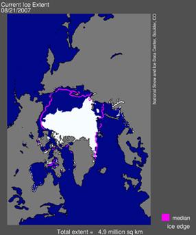
This past September, the ice cover in the Arctic Ocean melted back further than had occurred since records were started. In this image, you can see the ice extent on August 21, 2007 and the median ice edge (red line) for that same date from the data records. (The “median value� is the middle value) The ice melt-back in the Arctic this past summer is striking. How would the lack of ice in the ocean change the temperature in the Arctic? An article about the ice can be found here.

If you would like to monitor the current ice situation in the Arctic, you can go to this webpage.

You will see that I get really excited about snow. I started to take an interest in weather when I was 10 years old growing up in a suburb of Buffalo, New York. In 1977, there was an incredible blizzard there with over three feet of snow, winds gusting up to 70 mph (over 110 kph) and snow drifts over peoples’ houses. School was cancelled for 5 days straight. I thought it was the best thing going. Funny though that my love of missing school kept me in school through my Bachelors and Ph.D. in meteorology and now I am a professor and teach courses about the weather and climate.

Current Weather situation

It certainly has been colder than normal and there has been a lot of rain in the Great Lakes region. I was lucky enough to be at my parents’ house north of Buffalo, New York to experience two inches (5 cm) of snow on Thursday. The snow stayed on the ground throughout the weekend. Northeast Ohio and the Erie, Pennsylvania region got up to 6 inches (15 cm) of snow. Peggy LeMone, GLOBE Chief Scientist, said that there was some snow in and around Boulder, Colorado (5 inches or 13 cm at her house). Surprisingly to me, there was a snowstorm in western Texas, New Mexico and even in northern Mexico over the weekend. There is also a fair amount of snow in the mountains in Washington, Oregon, Idaho and Montana. You can go to the U.S. National Snow Analysis page on the NOAA website for the current snow cover and depth in the US: http://www.nohrsc.noaa.gov/nsa/.

I have most of my information from the USA because that is the easiest for me to get. I went to the GLOBE website to get observations of snow depth around the world. Some parts of northern Europe have snow on the ground as well including Poland and Estonia.

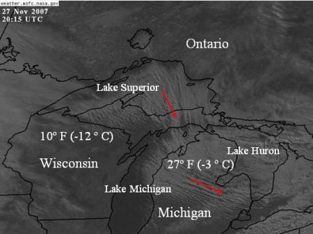
Currently, there is a low pressure system over Kentucky that has tapped the Gulf of Mexico for moisture. It is producing rain over much of the eastern USA with some snow starting to form in Michigan. There are a series of fronts associated with this storm that make it look like an octopus. There is a high pressure system over the mountain west. That is why the Santa Ana winds kicked up some fires in California again over the holiday weekend. Lastly, there is a cold front that stretches from Ontario that goes through Michigan and becomes a stationary front in Wisconsin. There is really cold air behind this front in southern Canada.

Map of the USA

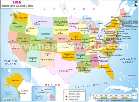
Map of the USA, to locate the states mentioned in the blog.

The Forecast

The long range forecast for the northern part of the US keeps hinting that a cold pattern will set up. This is the same pattern that gave the Great Lakes region the cold period from mid January to mid march last winter (2006-2007). It looks like we will continue to see storms, rain and snow, with colder than normal temperatures across the northern US. This is a big difference from last December. An Alberta Clipper (a fast moving storm that forms in Alberta (in West Central Canada) and comes down into the Great Lakes) will move through on Wednesday night and could produce an inch of snow especially in Michigan. These types of clippers are known for snow downwind of the lakes as well. This snow is called “lake effect snow” because the snowstorm gets moisture from the lake. This means more snow downwind of the lakes. The western side of Michigan should get some good lake effect snow Tuesday and then again Thursday through Friday. Also, northeast Ohio and Erie, Pennsylvania should get some measurable lake effect snow. The next major system will come through next weekend. Depending on its track, this weather system could produce significant snowfall over a larger area. Elsewhere, temperatures should remain near freezing in Estonia and Poland.

I talked to one teacher in Michigan today who said she couldn’t wait for the first snow day. I can’t wait either.

If you want to see where I get my weather information, you can go to my favorite weather pages.

Dr. C

SCUBAnauts Operation Deep Climb - Day 5

Tuesday, November 27th, 2007

As the Operation Deep Climb hikers make their way up Mauna Kea, not only does the team tire, but some are experiencing altitude sickness. This is because they live at sea level, and air pressure lowers as they get higher. By the time they stopped at 10,500 ft (3200 m), the air pressure was about 696 hectoPascals, and the air density was about 0.87 kilograms per cubic meter, compared to sea-level values of 1016 hectoPascals for air pressure and 1.2 kilograms per cubic meter for air density. This means that the oxygen content of the air was 73 per cent of its value at sea level. The symptoms of altitude sickness — headache, nausea, and dizziness — are rather common at higher altitudes for people who live at sea level. (For this reason, I had to abandon my first attempt at a “fourteener” here in Colorado — “fourteeners” are 14,000 feet [4268 meters] or higher).

To avoid altitude sickness, serious mountaineers wanting to summit 8,000-meter peaks not only spend a lot of time exercising to bring their body to a peak fitness level, but they try to spend some time at higher elevations before the climb to get their bodies acclimated to higher elevations. For comparison, the height of Mt. Everest is roughly 8,850 meters. Using the data from the Hilo sounding for 14 October the air pressure at that height is 332 hectoPascals, the temperature is -32 degrees Celsius, and the air density is 0.48 kilograms per cubic meter, which is 40% the value at sea level.

Day 5 - 15 October 2007

Anna - 16
Operation Deep Climb participant

Once I woke up this morning I began to pack my things. We talked with the cameramen and producers and today our teams would be different. Savannah was a team leader; in her group were David, Andrew and Collin. Mack was the leader of the team I was in; also with us were Santannah and Evan. We were also told that the groups would be kept together and so when would take a break so would the other. Today we started off hiking through very thick, knee high grass. Then we started to see rocky ridges and valleys. Then the terrain changed entirely to rocks, gravel and few trees. At one point Sergeant Gregory explained to us how to identify a poisonous plant, and most of us ate a dandelion. I tried it and it was a little tart.

Soon I noticed that there were no more trees or plant life and the landscape seemed more “like Mars.” At one point I had found a very interesting lava rock that I wanted to keep as a souvenir, but when I asked Bebe if I was allowed to take it, she said no and that Madame Pele would curse me if I did. Later I found an old horseshoe that Madame Pele would let me keep, so I am carrying that with me now. Today one of the members of the team I was in started to feel a little lousy. Mack was a good team leader and adjusted the rest of the team to help out our teammate. I also helped by helping to get my friend’s mind off of their condition by singing, you are lucky you couldn’t hear us.

SCUBAnauts picture

Our camp tonight is at around 10,500 feet (3,200 meters) of elevation, we were told that we were getting close and then the time went a lot more slowly. We finally saw where we would be spending the night. It was within walls of rocks that seemed to tower over our small tents. The view from this location was one of my favorite sights of this trip so far. We had passed the cloud level today and we were lucky enough to see the sunset at the cloud level.

I don’t know how but the producers brought us hot chocolate for our Nalgene bottles. I was told that the wind chill made it feel like it is in the forties (4.4-10 ° C), which is freezing to this Florida girl. Tonight I shared a tent with Santannah and Savannah. It seemed that everyone went to bed pretty early, I think that this happened mainly because it was so cold once the sun went down; there was nothing to do, but go to sleep. So far I have enjoyed this trip, I like the people that I am with and the production crew is also really fun. Everything we have said on camera is our own words, I have never been asked to say something or read off of a card. Sometimes when I was being filmed while answering a question, just to someone say, “Can you repeat that in a full sentence?” I think the strap of my pack may be bothering my neck, but this won’t stop me.

Mack - 15
Operation: Deep Climb participant

Day five started before the sun even rose, we had to get an early start because we where going to be covering a lot of ground today. The terrain for the beginning part of the day was long grass that was annoying to hike on but the worst was yet to come. At about noon we crossed the cinder line, which is where the trees end and the lava rock begins. The rock was really had to walk on especially up hill. People kept slipping and falling on the loose rock. We stopped for the night by a rock pile where we set up our tents, cooked our food, and went to sleep; for we were all very tired and knew the next day was going to be the day we summited.

SCUBAnauts picture

Santannah - 14
Operation: Deep Climb participant

The next day of the hike was the longest and most exhausting. Like yesterday, in the beginning of the hike I felt terrible. It was hard to breathe, I had a splitting headache and my body had not had time yet to recover from yesterday’s adventure. Then suddenly I felt amazing, better than amazing, as if I was a new person. The was around the same time that the scenery changed from a rolling hills like terrain to one that look as if it came straight off of Mars. Nothing but red rock and sand surrounded us. Soon my “buzz” wore off and I was back where I started, the back of the pack. I was cold, tired and my body just wanted to shut down. The closer I go to camp the further away it seemed.

When we finally reached camp we set up our tent and I put on as many layers as I could. I drank a lot of water and then slept.

SCUBAnauts Operation Deep Climb - Day 4

Tuesday, November 20th, 2007

What an exciting adventure for both groups! To see what kind of weather they were encountering, I obtained a radiosonde sounding at nearby Hilo, which is located on the east side of the island of Hawaii and east of Mauna Kea. Winds in the sounding were out of the east at 6-12 knots (3-6 meters per second, slightly higher than 6-12 miles per hour,), so the sounding was roughly upwind of the mountain. The students who rode to the top of Mauna Kea wrote that the temperature was at most 3.9 degrees Celsius; slightly warmer than the 2.6 degrees reported during the previous night, but not much.

SCUBAnauts picture

The time of the sounding was 2:00 a.m. local standard time (3 a.m. local daylight time), so the temperatures the students on the ground would have been somewhat warmer due to daytime heating. If the air upstream of Mauna Kea were cooler than on the mountain at the same height, what effect would strong winds have on the daytime warming of the mountain? How about if the winds were calm?

Astronomers like to observe from Mauna Kea because of the clear, dry air as well as distance from light pollution. (For more about light pollution, see GLOBE at Night). Clouds of course block their view of the sky. But even humid air affects their ability to observe (astronomers look at the sky not only using visible light but also longer wavelengths, where water vapor interferes). Also, the air is very stable, which reduces turbulence overhead, so that astronomers can observe in more detail. (Have you ever seen how images in the distance “shimmer” when you look at them across a hot parking lot on a summer day? The turbulent eddies bend the light going through them slightly, creating the shimmering effect. It’s fun to watch but not very good if you want a sharp image of a building on the other side of the parking lot.)

In addition to having to work to go uphill, the students were probably having some trouble hiking because of the altitude. Taking the sounding, I calculated the air density. By the time they reached the cabin, the air density, and hence the amount of oxygen available, was 85 per cent of the sea level value.

Here are the blog entries of the two groups of students: