Where did the rain come from?
Thursday, September 28th, 2006I was watching a baseball game at Coors Field in Denver, Colorado, USA, when a big fat raindrop fell on my lap. I looked up — and there were only small altocumulus clouds overhead.
Where did the drop come from? Not from the altocumulus clouds — they were too thin, and the raindrops were big, even if there were only a few, so I guessed they came from a cumulus-type cloud. No one was pouring a drink from the upper seats: the drop wasn’t sticky.
In this case, the explanation is probably simple. The raindrop took a long time to fall from its parent cloud. By the time the raindrop fell to the ground (or rather my lap), its parent cloud had either changed, or more likely moved out of sight.
Cumulus and cumulonimbus cloud bases over Colorado are often higher than usual. This is because the air is very dry. Dry air has to rise a long distance before it can form cloud. Why? Clouds like the one that produced the raindrops form when air rises and cools. As air cools, the relative humidity rises. Once the air is “saturated,” that is the relative humidity is 100 percent, tiny water drops start to form. If the air near the surface is moist, the air doesn’t have to rise very far. For example, over the tropical oceans, the base of cumulus clouds in fair weather is about 600 meters above the water. And, if the relative humidity at the ground is 100%, you can get fog — the cloud base is zero meters above the ground.
So, on dry days, we see cloud bases that are even 3000 meters above the surface.
Scientists have measured the fall speed of raindrops in the laboratory and using radars looking straight up. Larger raindrops fall at higher speeds. I will assume my raindrop fell toward the ground at 8 meters per second.
If the cloud base was at 3000 meters, it would take 3000 meters divided by 8 meters per second, or 375 seconds, for my raindrop to fall from the cloud to my lap. That’s over six minutes. During that six minutes, the cloud probably moved out of my sight. Coors field is surrounded by three tiers of seats and high walls; so my view of the cloud could be easily blocked. For example, if the wind at cloud level was 20 meters per second, the cloud would have moved 7.5 km away by the time the raindrop hit the surface. If the wind at cloud level was 40 meters per second, the cloud would have moved 15 kilometers away. So, the cloud could have easily moved behind the “nosebleed seats” (the highest seats).
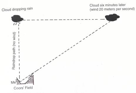
Illustration showing possible explanation for the rain with no cloud. Coors Field bleachers blocking my view. Not drawn to scale.
I assumed the raindrop would fall straight down from the cloud’s original position over my head. This would happen only if the wind was calm below cloud level. However, I don’t think it’s a bad guess, since the average wind between the cloud base and the ground could have been close to zero.
Just for fun — watch how the rain falls from distant clouds — sometimes it falls straight down (when the wind is the same through the rain and cloud), and sometimes it falls behind the cloud (when the wind “steering” the cloud is faster than the wind below cloud base), and sometimes it spreads out when it reaches the ground (when the air is also spreading out).