|
What's the difference between Ocean Surface Topography and Bathymetry?
TOPEX/Poseidon measures the precise shape of the ocean's surface (the surface topography). Bathymetry
refers to the relief on the floor of the ocean. The sea floor ridges, canyons, and abyssal plains,
that lie up to depths of five miles beneath the ocean surface, yield different gravitational pulls
on the ocean waters. The shape of the ocean bottom is thus reflected at the surface. For Nautical
charts see The National Ocean Service's (NOS) MapFinder.
Bathymetry
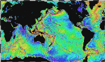
The map of the ocean floor (above) was produced by David Sandwell and Walter Smith using altimeter
data from Geosat and ERS altimeters. These two scientists have a highly recommended site,
Exploring the ocean basins with satellite
altimeter data, that explain the methods of deriving this map from ocean altimetry as well as uses for
this type of information. When TOPEX/Poseidon data are used in this type of product, they provide a minor
improvement because the track spacing at the equator is ~300 km, optimized for oceanographic studies. Other
satellites (Geosat, ERS-1) were temporarily placed in orbits that leave much smaller gaps
at the equator, precisely for this kind of work. Sandwell, D.T. and W.H.F Smith, Marine Gravity from Geosat
and ERS 1 Satellite Altimetry, J. Geophys. Res., v. 102, no. B5, p. 10039-10054, 1997.
Mean Sea Surface Height and Gravity
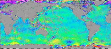
Above is an image of the mean Sea Surface Height produced by Geosat, the ERS satellites and TOPEX/Poseidon
data. The sea surface height measured by altimeters is mostly a measurement of the geoid, but it includes
a small (~1%) component due to the ocean circulation. This map has been produced primarily for oceanographers
studying ocean circulation using altimeter data. This map and related
gravity products, were produced by the Geodynamics Group at Raytheon under
contract to NASA.
Obtaining Bathymetric Charts
The National Ocean Service's (NOS) MapFinder provides direct
Internet access to NOS imagery and data holdings for coastal photography, nautical charts, historical maps,
coastal survey maps, environmental sensitivity index maps, hydrographic survey outlines, water level
stations, estuarine bathymetry, and geodetic control points. These are on-line as directly usable products,
or as previews of higher quality products that can be ordered from NOS.
|