SCIENCE
The following is a summary of what you'll find in this section.
To gather long-term
information about the world's oceans and currents, orbiting instruments
must take extremely precise measurements of the height of the ocean
surface - commonly called sea level
- above the center of the Earth. This is referred to as ocean surface topography; not to be
confused with bathymetry, which is the relief on the bottom of the ocean. Ocean
surface topography data contains information that has
significant practical applications in such areas as the study of worldwide
weather and
climate
patterns, the monitoring of shoreline evolution, and the protection
of our great ocean fisheries. There are many scientists studying this information.
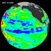
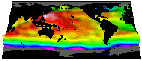
The image at right shows the latest satellite ocean surface topography data.
Ocean topography missions like TOPEX/Poseidon and Jason
seek to satisfy the following science goals:
- To determine general ocean circulation,
and to understand its role in the Earth's climate, and its hydrological
and biogeochemical cycles.
- To study the variation of ocean circulation on time scales from seasonal and annual to decadal and the effects on climate change.
- To collaborate with other global ocean monitoring programs to produce routine models of the global ocean for scientific and operational applications.
- To study large-scale ocean tides.
- To study geophysical processes from their effects on ocean surface topography.
Altimeter data are being used as part of a suite of data used as input into dynamic models for
long term climate forecasting and prediction. Other data sources include sea surface temperature
measurements from satellites, and in-situ measurements from buoys and drifters.
 For TOPEX/Poseidon and Jason-1, taking measurements and turning them into usable scientific data
products involves ground-based verification of the satellite measurements, an elaborate satellite
telecommunications system for transmitting and receiving the data from its instruments, and a
complex data processing effort involving two NASA centers and the French space agency CNES.
For TOPEX/Poseidon and Jason-1, taking measurements and turning them into usable scientific data
products involves ground-based verification of the satellite measurements, an elaborate satellite
telecommunications system for transmitting and receiving the data from its instruments, and a
complex data processing effort involving two NASA centers and the French space agency CNES.
Data from TOPEX/Poseidon and Jason-1 are delivered to customers
in map or digital form. Data products
are generated for:
|