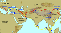
On the Road with Marco Polo: Crossing the Deserts of China
After resting up and replenishing their supplies in the trading city of Kashgar,
Marco Polo and his father and uncle continued eastward on their journey from
Venice to China. They had some difficult times ahead.
- Access Topography
of Eastern Asia available through Asia Source. Have the students find
Kashgar. Ask what lies between Kashgar and Beijing? (Two vast deserts—the
Taklimakan and the Gobi—both bounded by mountain ranges.)
- Go to Largest
Deserts of the World available through EDSITEment-reviewed resource Internet
Public Library. Find the Gobi and Taklimakan (also written Takla Makan).
Have the students locate these deserts (and perhaps some of the others listed)
on the classroom map of the world.
The Taklimakan is Asia's driest desert, a vast expanse of pebbles and sifting
sands nestled between two mountain ranges. The Polos chose a route that skirted
the southern edge of the desert, trudging through the arid landscape from one
oasis to the next. Each oasis was a welcome haven, offering fresh water, food
supplies, and pack animals. Some of these stopping places were famous for fresh
fruits, such as melons and grapes—a great treat for the weary travelers
whose diets consisted mostly of hard bread, cheese, salted meat, and water.
Today, a few of the ancient oases offer welcome relief to hot and thirsty tourists.
Student Activity:
- Access Taklimakan
available through Internet Public Library.
Think about the difficulties of crossing such a desert. No wonder merchants
chose to skirt this vast wasteland, choosing between routes going to the north
and to the south of it.
- Now access Where the
Gobi meets the Taklamakan available through EDSITEment-reviewed resource
Asia Source. A modern photograph shows that the Taklimakan is still a desolate
place.
- Go to Photographs
of Silk Road Photo Gallery available through EDSITEment-reviewed resource
Asia Source. Click on the images
of the terrain and inhabitants of the Taklimakan region to enlarge them.
Guiding Questions for Discussion:
- How would you describe the geography of the Taklimakan?
- What was (and is) the best way to travel from one end of the desert to the
other?
- How do some of the local inhabitants make a living?
At the eastern edge of the Taklimakan lay the city of Dunhuang, long famous
for its Buddhist temples, statues, and paintings.
Student Activity:
Learn about the ancient city of Dunhuang by accessing the following links
available through Asia Source.
- Silk Road available
through Asia Source. On the left
margin scroll down to maps, then trade routes, then China 3. With a cursor,
follow the route from Kashgar to Dunhuang. Find the major mountain ranges
on this map (the Pamirs, Hindu Kush, Tien Shan, Karakoram, and the Himalayas).
- Dunhuang
- Dunhuang
(Note: This website takes a long time to download (the first time viewed)
but is well worth the wait!)
Guiding Questions for Discussion:
- Where is Dunhuang?
- What type of art and architecture can be seen there?
- What factors led to Dunhuang becoming an important center of religious art?
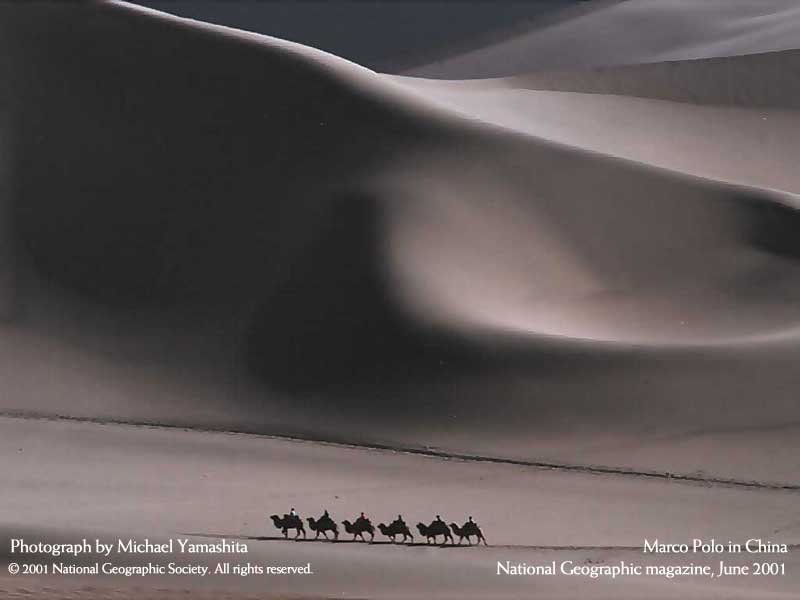
Most people associate desert crossings with camels, and rightly so. The merchants
who transported goods across the Taklimakan and the Gobi would have been in
a bad way without their sturdy, resilient camels—the “ships of the
desert.”
Student Activity:
Access the following sites about camels and study the texts and images:
Guiding Questions for Discussion:
- What has long been the major means of transporting goods (and people) across
the Taklimakan?
- What physical characteristics enable the camel to withstand the harsh environment
of the desert?
- What is the purpose of the bells used by the camel drivers?
- How would you describe the personality of a camel?
From Dunhuang, the Polos set out across the Gobi, Asia's largest desert. For
over a month they trekked through this harsh wasteland. Marco described how
travelers in the Gobi were often plagued by strange mirages (phantom figures
of friends in the distance) or frightening sounds (weird murmuring or repetitive
drumbeats). Such illusions were caused by the intensity of the sun, the lack
of water, and the seemingly endless stretches of the "unfriendly" landscapes.
Student Activity:
- Access Gobi
Desert available through Internet Public Library. Compare the geography
of the Gobi to that of the Taklimakan.
- View modern photographs of the Gobi by accessing China's
Unknown Gobi available through EDSITEment-reviewed resource Xpeditions.
- Return to the map entitled China 3 by accessing Silk
Road and scrolling down to maps, then trade routes,
then China 3. Find the Gobi Desert. What modern country does most
of this desert belong to? Find Beijing—the final destination of Marco
Polo.
Guiding Questions for Discussion:
- How does the Gobi compare to the Taklimakan?
- What were some of the psychological challenges posed to travelers by the
natural environment of the Gobi?
Assessment:
Divide the class into groups of three. Have each group select
a desert—the Taklimakan or the Gobi—and then make a poster, referring
to the websites visited in this lesson. The posters can be illustrated by images
downloaded, by images cut from magazines, or by original drawings.
Selected EDSITEment Websites
Asia Source
Internet Public Library
- Largest
Deserts of the World
[http://encarta.msn.com/encnet/refpages/RefMedia.aspx?refid=701500505]
- Taklimakan
[http://education.yahoo.com/reference/encyclopedia/
entry/Taklimak;_ylt=AggsXVvz_dGHeCIfR1C4XW5St8wF]
- Bactrian
camel
[http://encarta.msn.com/encnet/refpages/RefMedia.aspx?refid=461529631]
- Camels
in the Taklamakan
[http://encarta.msn.com/encnet/refpages/RefMedia.aspx?refid=461544696]
- Gobi
Desert
[http://education.yahoo.com/reference/encyclopedia/
entry/Gobi;_ylt=AuK8ulNXG2ggj4ytNrfusHJSt8wF]
Xpeditions
- China's
Unknown Gobi
[http://ngm.nationalgeographic.com/ngm/data/2002/
01/01/html/zm_20020101.4.4.html]
- Camel
convoy
[http://ngm.nationalgeographic.com/ngm/0106/
images/wallpaper_sm1.jpg]
- Camel
and donkey
[http://ngm.nationalgeographic.com/ngm/0106/feature2/zoom3.html]
- Silk Road
[http://www.silk-road.com/toc/index.html]
Standards Alignment
View your state’s standards
|

