| Subject Areas |
|
Art and Culture
|
| |
Anthropology |
| |
Architecture |
|
History and Social Studies
|
| |
World History - Africa |
| |
World History - Ancient World |
| |
World History - Asia/Far East |
| |
| Time Required |
| | Activity 1: 2 class periods (1 for lesson; 1 for assessment)
Activity 2: 2 class periods
Activity 3: 2 class periods
Activity 4: 2 class periods
Activity 5: 2 class periods
Activity 6: 2 class periods
Activity 7: 2 class periods
Activity 8: indeterminate
|
| |
| Skills |
| | Map skills
Observation and description
Historical interpretation and analysis
Critical Thinking
Information gathering
Visual analysis
Communication
|
| |
| Curriculum Unit |
|
Trekking to Timbuktu—Teacher Version
|
| |
| Additional Data |
| | Date Created: 10/15/03
|
| |
| Author(s) |
| |
Suzanne Art
,
|
| Date Posted |
| | 10/28/2003 |
| |
| Feedback |
| |
Send us your thoughts about this lesson! |
| |
| Email this Lesson |
| |
Send this lesson to friends or colleagues |
| |
|

|
Trekking to Timbuktu: The Geography of Mali —Teacher Version
Click here for Student Version—
Introduction:
The ancient city of Timbuktu lies in West Africa in the present-day nation of
Mali. This is a region of varied landscapes, ranging from sizzling desert sands
to tropical jungle. The Niger River that flows through Mali has been an important
trading highway as well as a source of subsistence for the local people since
very early times.
In this lesson, students will learn about the geography of Mali.
Guiding Questions:
Where is Mali?
What are the major geographical features of Mali?
In what part of Mali is Timbuktu?
What's the local weather?
What critical roles has the Niger River played in the lives of the people of
Mali?
How much have conditions changed?
Learning Objectives:
After completing this lesson, students will be able to
- Locate Mali on a world map
- Describe the landscape and climate of Mali
- Locate the city of Timbuktu and describe the local weather
- Indicate the route of the Niger River and discuss the river's economic significance
- Compare life along the Niger in ancient times to that of today
Become familiar with the lesson plan and bookmark important websites. You might
wish to download and duplicate the map of North Africa available at Outline
maps: available through EDSITEment-reviewed resource Internet Public Library.
Suggested Activities:
1. Finding Mali on the Map
2. Mali's Landscape and Climate
3. The Niger River
1. Finding Mali on the Map
West Africa is a large area of the African continent extending from Mauritania
on the Atlantic coast eastward to Niger and south to Nigeria. Mali is the largest
country in this region.
- Access Map
of Africa: This is a satellite map. Notice how the Sahara Desert (the
tan area) covers the entire northern part of Africa, with the exception of
a few coastal areas. Look at the western bulge of the continent. The parts
of this bulge that lie along the edge of the desert and south of it make up
a region known as West Africa.
- Now go to the Africa
Map. (The city's name is often spelled in the French manner - Tombouktou.
This is because Mali was once a part of French West Africa.)
- Go to Map of
Africa: This is a political map. Have the students point out Mali. Then
have them locate each of the other modern countries of West Africa: Mauritania,
Niger, Nigeria, Senegal, The Gambia, Guinea-Bissau, Guinea, Sierra Leone,
Liberia, Cote D'Ivoire, Burkina Faso, Ghana, Togo, Benin.
- Go to Map
of Africa available through EDSITEment-reviewed resource Labyrinth.
Have the students find Mali and Timbuktu. What is the capital of modern Mali?
(Bamako)
2. Mali's Landscape and Climate
The most habitable part of West Africa is a broad expanse of sahel and savanna
lying between the Sahara desert and the tropical rainforests of southern Guinea.
Most of modern Mali lies in this region.
- Go to Mali: Geography
and History: Have the students read the first paragraph and then find
Timbuktu (Tombouktou) on the map. How wide is the sahel? What are the three
distinct geographical regions of Mali? (The desert, a semi-arid strip of land,
and a more moderate region receiving plentiful rainfall)
- Now go to the Clickable
Map of Africa: available through EDSITEment-reviewed resource African
Studies WWW . Click on the section containing Mali and Niger. What is
the difference between the sahel and the savanna?
- Return to Map
of Africa:. Find the equator. Now find the lines of latitude known as
the Tropic of Cancer and the Tropic of Capricorn. Which is closest to Mali?
The area lying between these lines is known as the tropics.
- Access Temperature
in Timbuktu: What is the average daytime temperature in Timbuktu at this
time of year? Would the temperature vary very much from month to month? (Rather
than the four seasons enjoyed at other latitudes, equatorial locations generally
remain at the same temperature year round.)
3. The Niger River
The Niger River has long been the source of life and prosperity for the inhabitants
of the regions it flows through. The fertile inland delta of the river is in Mali.
- Access the Niger
River Basin Map. Follow the river from its source in Guinea to where it
loops southeastward (just beyond Timbuktu), then on to its mouth in Nigeria.
What countries does it flow through?
- Go to the map of Mali available through EDSITEment-reviewed
resource African
Studies WWW . Locate Timbuktu. Do you see the lakes? (Lac is
the French word for "lake.") How can there be lakes in such an arid land?
(They could be filled by underground springs. But in this case, they simply
fill up once a year from the overflow when the Niger floods its banks.)
- Return to Mali:
Geography and History. Have the students read paragraphs 3 and 4. In what
three ways has the Niger River been the source of subsistence for local inhabitants?
How often does the river flood? In earlier times, what major products were
transported along the river? View the fishermen
on the river: photographed by Lucy Johnson. Piroques like these
have been used for fishing and transportation along the Niger since ancient
times.
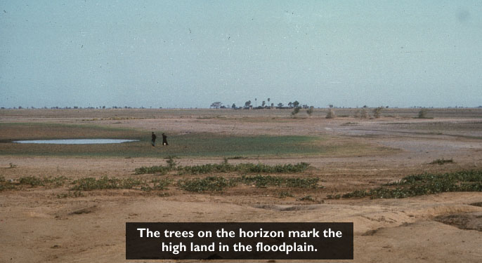
The prime farming area of the Niger is the inland delta in Mali. Like the Nile
River of ancient Egypt, the Niger floods its banks once a year, depositing a rich
new layer of silt on the floodplain in this wide, flat stretch of land.
- Access Landscapes.
Have the students read the first paragraph. During what time of year is the
annual flooding? About how much land is covered? You can view a photo of the
floodplain at Inland
Niger Delta Landscape: available through African
Studies WWW . View the close-up map of the delta and floodplain at Inland
Niger Delta. Notice that Timbuktu lies in the Sahara Desert, a few miles
inland from the river.
- Go to Wonders:
Niger River. Have the students read the second paragraph. What four food
economies thrive in the region of the inland delta?
- Read some first-hand accounts of life along the river by accessing The
Niger River available through EDSITEment-reviewed resource African
Studies WWW. What uses of the Niger did you find that hasn't been mentioned
before? (Washing and doing laundry.) After reading the text, click on "the
cattle crossing festival" and a fisherman's tale". In what ways does life along the river continue much as it did centuries
ago?
Assessment:
- Hand out copies of the map of North Africa found at Outline
maps: Have the students indicate with colored markers the Sahara Desert,
the sahel, and the savanna. Then have them label the following: Niger River,
inland delta of the Niger, modern-day Mali, Guinea, Niger, Benin, Nigeria,
and the city of Timbuktu.
- As a follow-up activity, instruct the students to write a short essay about
the Niger River. Preliminary to this activity, explain that a Greek historian
(Herodotus) once described ancient Egypt as "the gift of the Nile" After discussing
the meaning of this quotation, have the students think about ways in which
Mali might be considered "the gift of the Niger."
Selected EDSITEment Websites
African Studies WWW
[http://www.sas.upenn.edu/African_Studies/AS.html]
- Inland
Niger Delta Landscape:
[http://www.ruf.rice.edu/~anth/arch/mali-interactive/pictures/plains.jpg]
- Mali
[http://www.sas.upenn.edu/African_Studies/CIA_Maps/Mali_19856.gif]
- The
Niger River:
[http://www.oxfam.org.uk/coolplanet/ontheline/explore/journey/mali/niger.htm]
Internet Public Library
[http://www.ipl.org]
- Outline
maps:
[http://geography.about.com/gi/dynamic/offsite.htm?site=http%3A%2F%2Fwww.southernct.edu%2F%7Elukinbea%2Foutline.html]
Labyrinth
[http://www.georgetown.edu/labyrinth/]
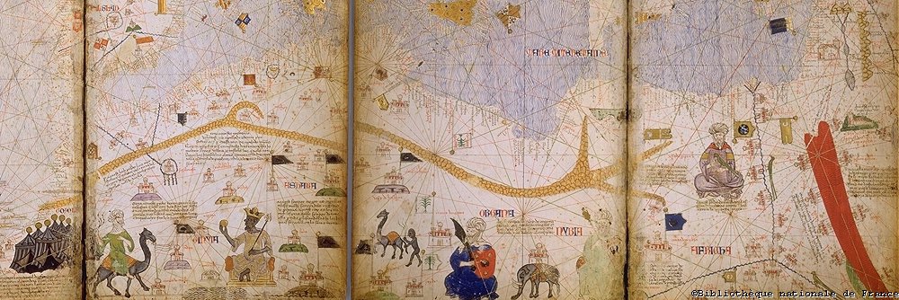
- enluminures
[http://www.bnf.fr/enluminures/images/jpeg/i8_0000m.jpg]
National Geographic Xpeditions
- Map of Africa:
[http://plasma.nationalgeographic.com/mapmachine/index.html?id=362&size=medium&left=-39&bottom=-34.6&right=72.8&top=38.2&point=x16.9,x1.8&text=Africa]
- Map of Africa:
[http://www.library.northwestern.edu/africana/map/]
Standards Alignment
View your state’s standards
|


