On the Road with Marco Polo: Marco Polo in China
After a long trek across the Gobi Desert, Marco Polo, his father, and his
uncle finally arrived at the Shangdu, the summer palace of Kublai Khan. At last
they stood face to face with the Emperor
of China (painting available through Asia Source)
At this time, most of Asia was under control of the Mongols, a nomadic people
whose homeland was in the Gobi. In the 12th century, Mongol leader Genghis Khan
had unified the many tribes of the Mongols and then led armies across Asia.
Student Activity:
- Access The Silk Road
available through Asia Source. Scroll
down to maps, select empires, then Mongol Empire.
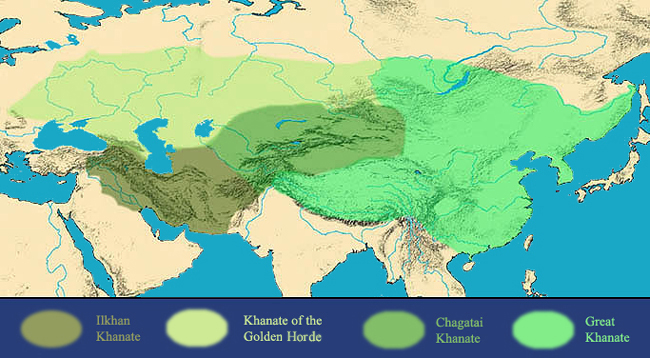
As you can see, the Mongol Empire was huge! In fact, it was the largest empire
in the history of mankind.
- Kublai Khan, grandson of Genghis Khan, now ruled the eastern part of the
empire, known as the Great Khanate. Go to Mongol
Empire available through Asia Source. Kublai's realm is shown on the map
in bright green—it included almost all of the land that makes up modern
China.
Guiding Questions for Discussion:
- Who were the Mongols?
- What was the Mongol Empire?
- Who was Kublai Khan, and what region did he rule?
Kublai Khan was very impressed with Marco's powers of observation and his
skill with language (he had picked up several local languages as he traveled
through Central Asia). So he appointed him to his court. For the next 17 years,
Marco was sent on many missions throughout the khan's realm.
Kublai's capital was built on the site of modern Beijing. It was known as Khanbalik
(a Mongol term meaning “City of the Khan” [note the alternate spelling:
Cambaluc]) and was located about 160 miles south of Shangdu. Kublai's vast empire
was made up of mountains, deserts, high plains, rivers, and fertile valleys.
Student Activity:
- Access the Small
map of China available through SARAI
Find Beijing. The two main rivers in China are the Huang He (Yellow River)
and the Chang Jiang (Yangtze River). Find them on the map. Notice that they
both flow from west to east.
- Go to the Elevation
map of China available through Ask Asia.
Find the Yellow River and the Yangtze River. Now find Beijing. Look at the
map key. Notice that the part of China colored green has the lowest elevation.
This is very fertile farmland watered by the rivers. It is where most of the
Chinese people have lived since very early times. Where are the highest mountains
in China located?
- Access Marco
Polo: The Glories of Kinsay available through Labyrinth.
This description of a Chinese city (Hangzhou) later appeared in Marco Polo's
book about his Asian adventures.
Guiding Questions for Discussion:
- What does China look like on a map?
- What are China's major rivers?
- Where do most of the Chinese live and why do they live there?
- What was life like in 13th century Hangzhou?
The Chinese city of Chang'an was the eastern terminus of the Silk Road. As
you would expect, it was a bustling center of trade, where merchants brought
products from Central Asia and even as far away as Europe to trade for Chinese
products.
- Access The Silk Road.
On the left margin scroll down to Maps, click Trade Routes,
then China 2. Point out the locations of Chang'an, Khanbalik, and
Shangdu.
The major Chinese products of the 13th century were silk, ceramics, carved
jade, lacquerware, and tea.
Student Activity:
View images and descriptions of these five Chinese products by accessing the
following resources available through Asia
Source:
Guiding Questions for Discussion:
- What were the major products of 13th century China?
- Where does silk come from, and how is silk cloth produced?
- What are the origins of Chinese pottery and porcelain?
- What is jade and why is it difficult to carve?
- What are the special properties of lacquerware?
- How is tea produced, and why did drinking tea become such a popular pastime?
Assessment:
Distribute copies of the blank map of China,
which you downloaded while preparing this lesson. Instruct the students to label
the approximate locations of Beijing (Khanbalik), Shangdu, and Chang'an, referring
to the maps previously viewed. You might also wish to have them sketch in the
Yellow and Yangtze Rivers as well as the Taklimakan and Gobi Deserts.
After completing the map, have the students choose one of the five products
described in this lesson (silk, porcelain, jade, lacquerware, and tea) as the
topic of a short report. Additional information can be found through EDSITEment-reviewed
resource Internet Public Library.
Selected EDSITEment Websites
Asia Source
Internet Public Library
Labyrinth
Xpeditions
- China
[http://www.nationalgeographic.com/xpeditions/atlas/index.html?Parent=
asia&Rootmap=china&Mode=b&SubMode=w]
SARAI
Standards Alignment
View your state’s standards
|

