Pacific Islands Water Science Center
 |
Recent hydrologic conditions, Iao and Waihee aquifer areas, Maui, HawaiiLast updated July 18, 2008 Introduction
Summary of recent conditions The 12-month moving mean of Iao aquifer area total pumpage was 16.36 Mgal/d as of June 2008 or about 1.89 Mgal/d less than in June 2007. The 12-month moving mean of Waihee aquifer area total pumpage was 5.59 Mgal/d as of June 2008 or about 1.16 Mgal/d more than in June 2007. Most water levels have decreased from April to July 2008 and are about the same as this time last year. Chloride concentration of the pumped water from well fields is the same in most well fields relative to the same time last year. Chloride-concentration data from the Waiehu deep monitor well indicate a rise in the middle of the transition zone of about 1.6 ft since April 2008 and about 6.2 ft since July 2007. The 12-month moving means of rainfall are below the long-term means of rainfall at the rain gages used for these quarterly updates. Streamflow was below the median during April-June 2008 at the gaging stations on Waihee River and Iao Stream during April-June 2008. Background information about the Iao and Waihee aquifer areas Since the introduction of pumping, ground-water levels have declined and the chloride concentrations of pumped water have risen above predevelopment levels at all of the well fields. In addition, the transition zone between freshwater and saltwater, which has been monitored at the Waiehu deep monitor well since 1985, has been moving upward during the period of record. The Iao aquifer lies on the flank of the West Maui Mountain and encompasses about 24.7 square miles. The boundaries of the Iao aquifer, as defined by the Commission on Water Resource Management (1990) and Mink and Lau (1990), are: the ridge south of Waihee River and north of Kalepa Gulch extending from the coast to the summit of West Maui Mountain; the crest of the West Maui Mountain; the ridge north of Waikapu Stream extending from the crest to the isthmus; and the southern divide of Iao Stream to Kahului Bay (click here to see a detailed map from US Geological Survey Water-Resources Investigations Report 00-4223 in .pdf format). The area is characterized by a steep and mountainous region to the west, an area of sloping alluvial and colluvial plains extending east from the mountains, and an area of lithified sand dunes and coastal plains near the ocean. The adjacent aquifer area north of the Iao aquifer is the Waihee aquifer which extends north to Kahakuloa Stream. The fresh ground-water system in the Iao aquifer contains: (1) dike-impounded water, (2) a freshwater lens floating on saltwater, and (3) perched water (click here for illustration in .pdf format). The dike-impounded water body is found in the mountainous interior part of the aquifer. A freshwater-lens system is found within the dike-free volcanic rocks and also in the coastal sedimentary deposits. Perched water in the sedimentary deposits overlying volcanic rocks is vertically separated from the freshwater lens by a zone of unsaturated rock. The general movement of fresh ground water in the Iao aquifer area is from the dike-impounded water body into the freshwater-lens system and then to the ocean (US Geological Survey Water-Resources Investigations Report 00-4223). Similar occurrences of ground water are expected in the Waihee aquifer area. Additional information about the Iao aquifer area can be found in: "The response of the Iao aquifer to ground-water development, rainfall, and land-use practices between 1940 and 1998, Island of Maui, Hawaii" by William Meyer and Todd K. Presley, 2001, US Geological Survey Water-Resources Investigations Report 00-4223 "Analytical versus numerical estimates of water-level declines caused by pumping, and a case study of the Iao aquifer, Maui, Hawaii" by Delwyn S. Oki and William Meyer, 2001, US Geological Survey Water-Resources Investigations Report 00-4244. A general description of the USGS cooperative program with the County of Maui Department of Water Supply can be viewed here. References: Commission on Water Resource Management, 1990, Water Resources Protection Plan: prepared by George A.L. Yuen and Associates, Inc., for Department of Land and Natural Resources, State of Hawaii, 262 p. Mink, J.F., and Lau, L.S., 1990, Aquifer identification and classification for Maui: groundwater protection strategy for Hawaii: Honolulu, Hawaii, University of Hawaii Water Resources Research Center, Technical Report no. 185, 47 p.
RainfallData provided by the State of Hawaii Commission on Water Resource Management, the Hawaii State Climate Office at the University of Hawaii at Manoa Meteorology Department, Maui Land and Pineapple Company, Inc., and the National Weather Service. 
Introduction The Iao and Waihee aquifer areas have a dramatic range in rainfall between Puu Kukui (altitude 5,788 ft) and the shoreline. The mean annual rainfall at Puu Kukui (greater than 371 in.) is the second highest recorded in the State. Mean annual rainfall declines rapidly toward the ocean and is 30 in. or less at the shoreline. Precipitation in the area is actually a combination of rainfall over all elevations and fog drip at higher elevations where the montane forest canopy intercepts cloud water. Fog drip has not been measured on West Maui Mountain, but studies of other high mountains in Hawaii have shown that fog drip can significantly augment rainfall at elevations above 2,000 ft (US Geological Survey Water-Resources Investigations Report 00-4223). Four rainfall stations are reported here. Station 380, Puu Kukui, at an altitude of 5,790 ft, includes rainfall data for 1928-present. Station 482, Waihee Valley, at an altitude of 300 ft, includes data for 1913-present. Station 484, Waiehu Camp, at an altitude of 320 ft, includes data for 1910-present. At Wailuku, Station 486 at an altitude of 180 ft, includes data for 1887-2002 (discontinued) and Station WUKH1 (NWS Hydronet station) nearby includes data from 2003-present compared with historical data from Station 486. Summary of recent conditions Rain-gage data are current through June at Puu Kukui rain gage and May at Waihee Valley and Waiehu Camp rain gages. Wailuku data is missing since February 2008. The 12-month moving mean decreased at the three available gages and the 12-month moving means of rainfall are below the long-term means at these three gages. The 12-month moving mean is about 70 percent of the long-term mean (370 in/yr) at Puu Kukui. At Wailuku, the 12-month moving mean is not available. The long-term mean is 30 in/yr. At Waiehu Camp, the 12-month moving mean is at about 73 percent of the long-term mean (35 in/yr). At Waihee Valley, the 12-month moving mean is at about 69 percent of the long-term mean (45 in/yr). Additional information about the Iao aquifer area can be found in: "The response of the Iao aquifer to ground-water development, rainfall, and land-use practices between 1940 and 1998, Island of Maui, Hawaii" by William Meyer and Todd K. Presley, 2001, US Geological Survey Water-Resources Investigations Report 00-4223 "Analytical versus numerical estimates of water-level declines caused by pumping, and a case study of the Iao aquifer, Maui, Hawaii" by Delwyn S. Oki and William Meyer, 2001, US Geological Survey Water-Resources Investigations Report 00-4244
Twelve-month moving mean of rainfall at Puu Kukui, Wailuku, Waihee Valley, and Waiehu Camp rain gages, 1985 to present. Pumpage at well fieldsPumpage data provided by the County of Maui Department of Water Supply (DWS). 
Introduction Ground-water withdrawal in the Iao and Waihee aquifer areas provides water to the Wailuku area and the populated central isthmus of the island. In 1998, about 76 percent of the ground water supplied by the DWS to the island was from the Iao aquifer (unpub. data from DWS). Significant ground-water withdrawal from the Iao aquifer for irrigation began in 1948 to supplement the water diverted by ditch systems. Withdrawal for domestic use from Iao aquifer area began in 1955. Since 1985, water has been pumped only for domestic use, and is withdrawn from five locations in the Iao aquifer (Waihee well field, Waiehu Heights well field, Mokuhau well field, Kepaniwai well, and shaft 33) and two locations in the Waihee aquifer (North Waihee and Kanoa well fields). In 1990, the State of Hawaii Commission on Water Resource Management established 20 Mgal/d as the sustainable yield of the Iao aquifer (Commission on Water Resource Management, 1990). This pumpage value was surpassed by 0.50 and 0.35 Mgal/d in 1995 and 1996, respectively (US Geological Survey Water-Resources Investigations Report 00-4223). The sustainable yield of the Waihee aquifer was established at 8 Mgal/d. Well-construction information for wells described in this web page is available here. Summary of recent conditions The 12-month moving mean of Iao aquifer total pumpage (not including North Waihee and Kanoa well fields) through June 2008 was 16.36 Mgal/d. The 12-month moving mean of total pumpage decreased by about 1.89 Mgal/d relative to the mean for June 2007. The mean of the Iao aquifer total pumpage during Apr-Jun 2008 was lower than Apr-Jun 2007 by about 2.29 Mgal/d (17.18 compared to 19.48 Mgal/d). The mean of the total pumpage was higher during Apr-Jun 2008 than Jan-Mar 2008 by about 2.56 Mgal/d. The 12-month moving mean of Waihee aquifer total pumpage (North Waihee and Kanoa well fields) through June 2008 was 5.59 Mgal/d. The 12-month moving mean of total pumpage increased by about 1.16 Mgal/d relative to the mean for June 2007. The mean of the Waihee aquifer total pumpage during Apr-Jun 2008 was higher than Apr-Jun 2007 by about 0.24 Mgal/d (5.01 Mgal/d compared to 4.77 Mgal/d). The mean of the total pumpage was lower during Apr-Jun 2008 than Jan-Mar 2008 by about 0.73 Mgal/d. The 12-month moving means for June 2008 relative to June 2007 changed the most at Waiehu Heights and Mokuhau well fields. Waiehu Heights well field decreased by 0.95 Mgal/d and Mokuhau well field decreased by 0.81Mgal/d. Pumpage differences between Apr-Jun 2008 and Apr-Jun 2007 were most notable at Kanoa and Mokuhau well fields. Pumpage increased by 1.10 Mgal/d at Kanoa well field and decreased by 0.95 Mgal/d at Mokuhau well field . Pumpage decreased during Apr-Jun 2008 relative to Jan-Mar 2008 at North Waihee well field by 0.91 Mgal/d, stayed about the same at Kepaniwai well and Shaft 33, and increased at Waihee, Mokuhau, Kanoa, and Waiehu Heights well fields by 2.12, 0.33, 0.18, and 0.12 Mgal/d. This summary incorporates corrections to historical pumpage data after January 2001 as provided by the County of Maui Department of Water Supply on November 8, 2004. Additional information about the Iao aquifer area can be found in: "The response of the Iao aquifer to ground-water development, rainfall, and land-use practices between 1940 and 1998, Island of Maui, Hawaii" by William Meyer and Todd K. Presley, 2001, US Geological Survey Water-Resources Investigations Report 00-4223 "Analytical versus numerical estimates of water-level declines caused by pumping, and a case study of the Iao aquifer, Maui, Hawaii" by Delwyn S. Oki and William Meyer, 2001, US Geological Survey Water-Resources Investigations Report 00-4244] References: Commission on Water Resource Management, 1990, Water Resources Protection Plan: prepared by George A.L. Yuen and Associates, Inc., for Department of Land and Natural Resources, State of Hawaii, 262 p.
Monthly pumpage for selected wells and Iao aquifer total pumpage and 12-month moving mean of total pumpage, 1984 to present. 
Annual pumpage for selected wells and Iao aquifer domestic and total pumpage, 1948 to present.
Monthly pumpage for North Waihee and Kanoa well fields, 1997 to present.
Combined monthly pumpage for Iao and Waihee aquifers, 1984 to present.
12-month moving mean of pumpage and comparison to previous year's 12-month moving mean for Iao and Waihee aquifers, 1998 to present. A positive difference indicates a higher rate than the previous year's rate.
12-month moving mean of pumpage and comparison to previous year's 12-month moving mean for Iao and Waihee aquifer individual wellfields, 1998 to present. A positive difference indicates a higher rate than the previous year's rate. Table 1. Pumpage, in million gallons per day, for the Iao and Waihee aquifer areas, Maui, Hawaii, July 2007-June 2008.
Note: 12-month moving mean is the mean of the monthly pumpage values for a given month and the previous 11 months Water levels in wellsData collected by the U. S. Geological Survey in cooperation with the County of Maui Department of Water Supply and the State of Hawaii Commission on Water Resource Management. Data after September 30, 2007 are provisional and subject to revision. 
Introduction (summarized from US Geological Survey Water-Resources Investigations Report 00-4223) Ground-water withdrawal from the Iao and Waihee aquifer areas has caused an overall decline in water levels that has resulted in a corresponding rise of the freshwater/saltwater transition zone. Pumping from each well field generates a cone of depression that overlaps with the cones of depression from one or more of the other well fields. Water levels in the Iao aquifer area have been monitored for various periods of time since 1940. Available data indicate that water levels not only respond to pumping, but also correspond closely to the departure of the mean of the preceding 12 months of rainfall from the mean rainfall of the entire record. In addition, water levels fluctuate seasonally, with annual highs occurring in the winter and lows occurring in the late summer or early fall. Well-construction information for wells described in this web page is available here. Summary of recent conditions Water levels in most of the wells decreased during April-July 2008. Water levels are generally the same as levels from this time last year. Recent efforts to resurvey the measuring-point elevations of the wells used in this web page have been incorporated into the water level plots. The water levels presented here have been adjusted for the new measuring points for measurements made starting October 2003. Water level measurements made prior to October 2003 have not been adjusted in this web page. Click here for details of the recent resurveying efforts. (click on well or page down to see water-level graphs) These ground-water stations are operated by Matt Wong of the USGS Maui field office. Additional information about the Iao aquifer area can be found in: "The response of the Iao aquifer to ground-water development, rainfall, and land-use practices between 1940 and 1998, Island of Maui, Hawaii" by William Meyer and Todd K. Presley, 2001, US Geological Survey Water-Resources Investigations Report 00-4223 "Analytical versus numerical estimates of water-level declines caused by pumping, and a case study of the Iao aquifer, Maui, Hawaii" by Delwyn S. Oki and William Meyer, 2001, US Geological Survey Water-Resources Investigations Report 00-4244
Water levels for selected wells and total monthly pumpage for Iao aquifer, 1984 to present. Water levels after October 1, 2003 are calculated using updated measuring points. Water levels for Waikapu 1 and 2 and total monthly pumpage for Iao aquifer, 1984 to present. Most recent water-level measurements: Waikapu 1 - 10.56 ft, July 1,
2008; Waikapu 2 - 10.97 ft, July 1,
2008. Water levels after October 1, 2003 are calculated using updated measuring points. Water levels and total monthly pumpage for shaft 33, 1984 to present. Most recent water-level measurement: 8.16 ft, August 16, 2006. Data from observation well about 10 ft from pumping well in shaft. Water levels after October 1, 2003 are calculated using updated measuring point. Regular water-level measurements for shaft 33 have been discontinued due to safety concerns. Water levels for Mokuhau pump 2 and total monthly pumpage for Iao aquifer and Mokuhau well field, 1984 to present. Most recent water-level measurement: 6.77 ft, July 1,
2008. Mokuhau pump 2 pumpage discontinued in 1995. Water levels after October 1, 2003 are calculated using updated measuring point. Water levels for test hole E and total monthly pumpage for Iao aquifer, 1984 to present. Most recent water-level measurement: 12.21 ft, April 1, 2005. During the field visit of July 2005, access to test hole E was found to have been destroyed. Future measurements at this monitoring well appear doubtful. Water levels after October 1, 2003 are calculated using updated measuring point. Water levels for test hole B and total monthly pumpage for Iao aquifer, 1984 to present. Most recent daily mean water-level: 7.97 ft, June 30, 2008. Water levels after October 1, 2003 are calculated using updated measuring point. Water levels for Waiehu deep monitor well and total monthly pumpage for Iao aquifer, 1984 to present. Most recent daily mean water-level measurement: 9.31 ft, July 1,
2008. Water levels after October 1, 2003 are calculated using updated measuring point. 
Water levels for test hole A1 and total monthly pumpage for Iao aquifer, 1984 to present. Most recent water-level measurement: 9.82 ft, May 14,
2008. Water levels after October 1, 2003 are calculated using updated measuring point. Measurements were not made at Test Hole A during July 2006-August 2007 because of landowner access problems. Water levels for North Waihee pump 1 and total monthly pumpage for Iao aquifer and North Waihee well field, 1984 to 2002. Most recent water-level measurement: 7.48 ft, October 1, 2002. Water-level measurements have been discontinued at this site since October 2002 because the well is being pumped. Water levels for Kanoa test hole and Waihee aquifer and total monthly pumpage for Kanoa well field, 1997 to present. Most recent daily mean water level: 4.56 ft, June 18,
2008. All water levels are calculated using updated measuring point. Water levels for Iao monitoring well and total monthly pumpage for Shaft 33, 1984 to present. Most recent daily mean water level: 13.36 ft, June 25, 2008. Water levels for Kepaniwai observation well and total monthly pumpage for Kepaniwai pumped well, 1984 to present. Most recent water-level measurement: 641 ft, July 1
,
2008.
Chloride concentration of pumped waterChloride data provided by the County of Maui Department of Water Supply.
Introduction (summarized from US Geological Survey Water-Resources Investigations Report 00-4223) Changes in chloride concentration of pumped water over time can be a function of the pumping rate of a particular well, pumping at nearby wells, depth of the well, and overall aquifer trends. Therefore, the evaluation of aquifer conditions based on chloride-concentration trends from the pumped wells has limitations. If pumpage is held constant, however, changes in chloride concentration of water from a production well can be valuable for interpreting chloride-concentration trends at that location. Despite the increase in chloride concentration at many of the wells in the Iao and Waihee aquifer areas since the introduction of pumping, the chloride concentration of the pumped water has been below the USEPA secondary maximum contaminant level of 250 mg/L for all pumped wells in the aquifer, except for the water from Mokuhau pumps 1 and 2 and Waiehu Heights pump 1. Chloride concentrations at these wells have been as high as 500 mg/L. Chloride concentrations in pump 3 at the Mokuhau well field have occasionally reached 240 to 250 mg/L. Well-construction information for wells described in this web page is available here. Summary of recent conditions Chloride concentrations of pumped water during Apr-Jun 2008 were higher compared to this time last year at Waihee and Kanoa well fields. Chloride concentrations of pumped water during Apr-Jun 2008 were lower at Mokuhau and Waiehu Heights well fields and about the same at North Waihee well field and at shaft 33 and Kepaniwai pumped well. Waihee pump 1 chloride concentrations were slightly higher during Apr-Jun 2008 relative to Apr-Jun 2007. Chloride concentrations in Apr-Jun 2008 were about 39 to 50 mg/L, whereas in Apr-Jun 2007 chloride concentrations were 31 to 49 mg/L. Waihee pump 2 chloride concentrations were higher during Apr-Jun 2008 relative to Apr-Jun 2007. Chloride concentrations in Apr-Jun 2008 were about 71 to 75 mg/L, whereas in Apr-Jun 2007 chloride concentrations were 48 to 59 mg/L. Waihee pump 3 chloride concentrations during Apr-Jun 2008 were 26 to 27 mg/L, whereas in Apr-Jun 2007 chloride concentrations were 20 to 26 mg/L. Chloride concentrations in Apr-Jun 2008 were 104 to 132 mg/L, whereas in Apr-Jun 2007 chloride concentrations were not measured. Waiehu Heights pump 2 chloride concentrations were lower during Apr-Jun 2008 relative to Apr-Jun 2007. Waiehu Heights pump 2 chloride concentrations during Apr-Jun 2008 were 57 to 66 mg/L, whereas in Apr-Jun 2007 chloride concentrations were 109 to 121 mg/L. Mokuhau pump 1 chloride concentrations were about the same during Apr-Jun 2008 relative to Apr-Jun 2007. Chloride concentrations in Apr-Jun 2008 were 119 to 122 mg/L, whereas in Apr-Jun 2007 chloride concentrations were 114 to 135 mg/L. Mokuhau pump 3 chloride concentrations were lower during Apr-Jun 2008 relative to Apr-Jun 2007. Mokuhau pump 3 chloride concentrations during Apr-Jun 2008 were 98 to 108 mg/L, whereas in Apr-Jun 2007 chloride concentrations were 109 to 136 mg/L. Chloride concentration of the pumped water from shaft 33 has had an upward trend from 1996 to 2008. Chloride concentrations in 1996 were about 33 to 38 mg/L, whereas in 2008 chloride concentrations were about 57 to 58 mg/L. Chloride concentrations of the pumped water at Kepaniwai pumped well remained constant at about 13 to 16 mg/L during Apr-Jun 2008. Chloride concentration of the pumped water at this well has been at or below 21 mg/L for the previous seven years. In the Waihee aquifer area, chloride concentration of the pumped water from Kanoa well field was higher during Apr-Jun 2008 relative to Apr-Jun 2007. Chloride concentrations in Apr-Jun 2008 were 39 to 45 mg/L, whereas in Apr-Jun 2007 chloride concentrations were 25 to 29 mg/L. North Waihee well field has remained relatively constant, with one exception, through the period of record with North Waihee pumps 1 and 2 ranging between 14 and 30 mg/L except for one value of 61 mg/l in North Waihee pump 1 in July 2005. Additional information about the Iao aquifer area can be found in: "The response of the Iao aquifer to ground-water development, rainfall, and land-use practices between 1940 and 1998, Island of Maui, Hawaii" by William Meyer and Todd K. Presley, 2001, US Geological Survey Water-Resources Investigations Report 00-4223 "Analytical versus numerical estimates of water-level declines caused by pumping, and a case study of the Iao aquifer, Maui, Hawaii" by Delwyn S. Oki and William Meyer, 2001, US Geological Survey Water-Resources Investigations Report 00-4244 Chloride concentrations for Waihee pumps 1, 2, and 3 and total monthly pumpage for Waihee well field, 1985 to present. Chloride concentrations for Waiehu Heights pumps 1 and 2 and total monthly pumpage for Waiehu Heights well field, 1985 to present. Chloride concentrations for Mokuhau pumps 1, 2, and 3 and total monthly pumpage for Mokuhau well field, 1985 to present. Mokuhau pump 2 discontinued pumping in 1995. Chloride concentrations and total monthly pumpage for Kepaniwai pumped well, 1985 to present. Chloride concentrations and total monthly pumpage for shaft 33, 1991 to present. Chloride concentrations for North Waihee pumps 1 and 2 and total monthly pumpage for North Waihee well field, 1997 to present. Chloride concentrations for Kanoa pumps 1 and 2 and total monthly pumpage for Kanoa well field, 2000 to present. Waiehu and Iao deep monitor wellsWaiehu deep monitor well chloride data collected by U. S. Geological Survey in cooperation with the the State of Hawaii Commission on Water Resource Management. Iao deep monitor well data collected by the State of Hawaii Commission on Water Resource Management. U. S. Geological Survey data after September 30, 2007 are provisional and subject to revision.  Introduction (summarized
from US
Geological Survey Water-Resources Investigations Report
00-4223) Introduction (summarized
from US
Geological Survey Water-Resources Investigations Report
00-4223)
The Waiehu deep monitor well, drilled to an altitude of -1,020 ft, and the Iao deep monitor well, drilled to an altitude of -1,118 ft penetrate through most of the transition zone. Because the amount of water that can be developed from a freshwater lens for potable use is constrained by the salinity of the water, the altitude of the top of the transition zone (where chloride concentration is 2 percent that of seawater) and the thickness of the transition zone are important. Since 1985, water samples for chloride-concentration analysis have been collected quarterly from discrete depths in the Waiehu deep monitor well to track the vertical movement of the transition zone. Chloride-concentration data from the well would be expected to most reflect changes in the aquifer as a result of pumping from the Waihee and Waiehu Heights well fields because the deep monitor well is located closest to these well fields. Fluid conductivity data have been collected from the Iao deep monitor well since 2006. The movement of the transition zone is in response to water-level changes caused by variations in pumping and rainfall. Because the wells are uncased below sea level, it is possible that the concentration of the water collected at any depth in the well is affected by borehole flow. Thus, concentration for a given depth may not reflect the actual concentration of water in the aquifer at that depth. Nevertheless, discrete sampling with depth over time provides a general pattern of transition-zone thickness and relative movement. Well-construction information for wells described in this web page is available here. Summary of recent conditions Waiehu deep monitor well Chloride concentrations at Waiehu deep monitor well increased at depths of -200 ft to -675 ft during April-July 2008. The profile plots indicate a rise of about 165 ft in the mid-point of the transition zone since August 1985. The expanded profile plot, indicates that the midpoint of the transition zone (-657 ft altitude) has risen by about 1.6 feet since April 2008, and risen by about 6.2 feet since July 2007. A plot of the position of two salinity values (2-percent and 50-percent seawater chloride concentration) in the transition zone shows the rise of the transition zone through time. This plot indicates that the rise had been fairly steady from the early 1990’s until the present. However, the most recent data show a steeper trend line for the rise of the 2-percent seawater position. This rise appears mainly because the a part of the transition zone where chloride concentrations change rapidly with depth has moved into a part of the aquifer where the monitoring well samples are collected at wider depth intervals. Adjustments to the sampling depth spacing were made to provide more resolution in this part of the transition zone. The State of Hawaii Commission on Water Resource Management also monitors this well and their data show a similar trend. Iao deep monitor well The profile plot shows the position of the transition zone in May 2006, several months after the well was drilled, and June 2008.
Additional information about the Iao aquifer area can be found in: "The response of the Iao aquifer to ground-water development, rainfall, and land-use practices between 1940 and 1998, Island of Maui, Hawaii" by William Meyer and Todd K. Presley, 2001, US Geological Survey Water-Resources Investigations Report 00-4223 "Analytical versus numerical estimates of water-level declines caused by pumping, and a case study of the Iao aquifer, Maui, Hawaii" by Delwyn S. Oki and William Meyer, 2001, US Geological Survey Water-Resources Investigations Report 00-4244 Chloride-concentration profiles for the Waiehu deep monitor well, August 1985, April 2007, and April 2008.
Chloride-concentration profiles for the Waiehu deep monitor well, April 2007, January 2008, and April 2008. Altitude of the top (2-percent seawater) and mid-point (50-percent seawater) of the transition zone, Waiehu deep monitor well, 1985 to present.
Fluid-conductivity profiles for the Iao deep monitor well, May 2006 and September 2007. StreamflowStreamflow data collected by the U. S. Geological Survey in cooperation with the State of Hawaii Commission on Water Resource Management. Data after September 30, 2007 are provisional and subject to revision. Diversion data provided by the State of Hawaii Commission on Water Resource Management. 
Introduction Four main perennial streams overlay the Iao and Waihee aquifer areas, Waihee River and Iao, Waiehu, and Makamakaole Streams. The largest, Waihee River, has the highest median flow from any gaged stream on Maui, averaging 54 ft3/s at an altitude of 605 ft (USGS gaging station 16614000) from 1984 to the present. Iao Stream, at an altitude of 780 ft (USGS gaging station 16604500), has the second highest gaged median flow, averaging 40 ft3/s from 1983 to the present (Flow Statistics for USGS Stream-Gaging Stations Operated in Hawaii from 1909-2005). Waihee River and Iao Stream flow from the wet interior of the West Maui mountains where the water has cut deep valleys into the low-permeability volcanic dike compartments which impound ground-water to high altitudes. Ground water leaking from these breached dike compartments provides flow in the streams (base flow) even during prolonged periods of little or no rainfall. Downstream of the USGS gaging stations, the streams are diverted and the water is transported by tunnels and ditches for use in agricultural irrigation. The stream diversion structures are designed to capture all of the the low flow and the streams are dry in some sections downstream of the diversions. Information about streams in the area from: "Preliminary report on the water resources of the Wailuku area, Maui: State of Hawaii, Department of Land and Natural Resources, Division of Water and Land Development, Circular C61, 43 p." by Yamanaga, George, and Huxel, C.J., 1970. Summary of recent conditions Streamflow in Waihee River during April-June 2008 was 64 percent of the median for those months and for the past year streamflow was 90 percent of the median. The Waihee River real-time streamflow gaging station is updated hourly via satellite. Streamflow in Iao Stream during Apr-Jun 2008 was 54 percent of the median for those months and for the past year streamflow was 117 percent of the median. Streamflow duing May and June was near or at record lows for the period of record (1983-2008). The Iao Stream real-time streamflow gaging station is updated hourly via satellite. Streamflow record from previous year
Stream-diversion data, as provided by the State of Hawaii Commission on Water Resource Management, are plotted in gray. Recent streamflow record compared with historical data
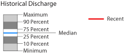
Monthly mean discharge data show how recent conditions compare to the range of monthly discharge measured in the historical record. The entire period of record is used to estimate the historical maximum and minimum discharge as well as several percentiles. Streamflow and reported stream diversion data, in million gallons per day [na, not available; nr, not reported; diversion data provided by the State of Hawaii Commission on Water Resource Management]
| |||||||||||||||||||||||||||||||||||||||||||||||||||||||||||||||||||||||||||||||||||||||||||||||||||||||||||||||||||||||||||||||||||||||||||||||||||||||||||||||||||||||||||||||||||||||||||||||||||||||||||||||||||||||||||||||||||||||||||||||||||||||||||||||||||||||||||||||||||||||||||||||||||||||||||||||||||||||||||||||||||||||||||||||||||||||||||||||||||||||||||||||||||||||||||||||||||||||||||||||||||||||||||||||||||||||||||||||||||||||||||||||||||||||||||||||||||||||||||||||||||||||||||||||||||||||||||||||||||||||||||||||||||||||||||||||||||||||||||||||||||||||||||||||||||||||||||||||||||||||||||||||||||||||||||||||

|
||||||||||||||||||||||||||||||||||||||||||||||||||||||||||||||||||||||||||||||||||||||||||||||||||||||||||||||||||||||||||||||||||||||||||||||||||||||||||||||||||||||||||||||||||||||||||||||||||||||||||||||||||||||||||||||||||||||||||||||||||||||||||||||||||||||||||||||||||||||||||||||||||||||||||||||||||||||||||||||||||||||||||||||||||||||||||||||||||||||||||||||||||||||||||||||||||||||||||||||||||||||||||||||||||||||||||||||||||||||||||||||||||||||||||||||||||||||||||||||||||||||||||||||||||||||||||||||||||||||||||||||||||||||||||||||||||||||||||||||||||||||||||||||||||||||||||||||||||||||||||||||||||||||||||||||||

 The
Iao and Waihee aquifer areas, on the eastern side of West Maui Mountain,
are the principal source of domestic water supply for the island of Maui.
In cooperation with the County of Maui
The
Iao and Waihee aquifer areas, on the eastern side of West Maui Mountain,
are the principal source of domestic water supply for the island of Maui.
In cooperation with the County of Maui